File:East-Hem_1000bc.jpg
From Wikipedia, the free encyclopedia
Dimension de iste previsualisation: 800 × 470 pixels.Altere resolutiones: 320 × 188 pixels | 640 × 376 pixels | 1 024 × 601 pixels | 1 280 × 752 pixels | 3 240 × 1 903 pixels.
File original (3 240 × 1 903 pixels, dimension del file: 1,43 MB, typo MIME: image/jpeg)
Iste file proveni de Wikimedia Commons e pote esser usate per altere projectos. Le description de su pagina de description ibi es monstrate in basso.

|
This historical map image could be re-created using vector graphics as an SVG file. This has several advantages; see Commons:Media for cleanup for more information. If an SVG form of this image is available, please upload it and afterwards replace this template with
{{vector version available|new image name}}.
It is recommended to name the SVG file “East-Hem 1000bc.svg”—then the template Vector version available (or Vva) does not need the new image name parameter. |
 | This historical map image was uploaded in the JPEG format even though it consists of non-photographic data. This information could be stored more efficiently or accurately in the PNG or SVG format. If possible, please upload a PNG or SVG version of this image without compression artifacts, derived from a non-JPEG source (or with existing artifacts removed). After doing so, please tag the JPEG version with {{Superseded|NewImage.ext}} and remove this tag. This tag should not be applied to photographs or scans. If this image is a diagram or other image suitable for vectorisation, please tag this image with {{Convert to SVG}} instead of {{BadJPEG}}. If not suitable for vectorisation, use {{Convert to PNG}}. For more information, see {{BadJPEG}}. |  |
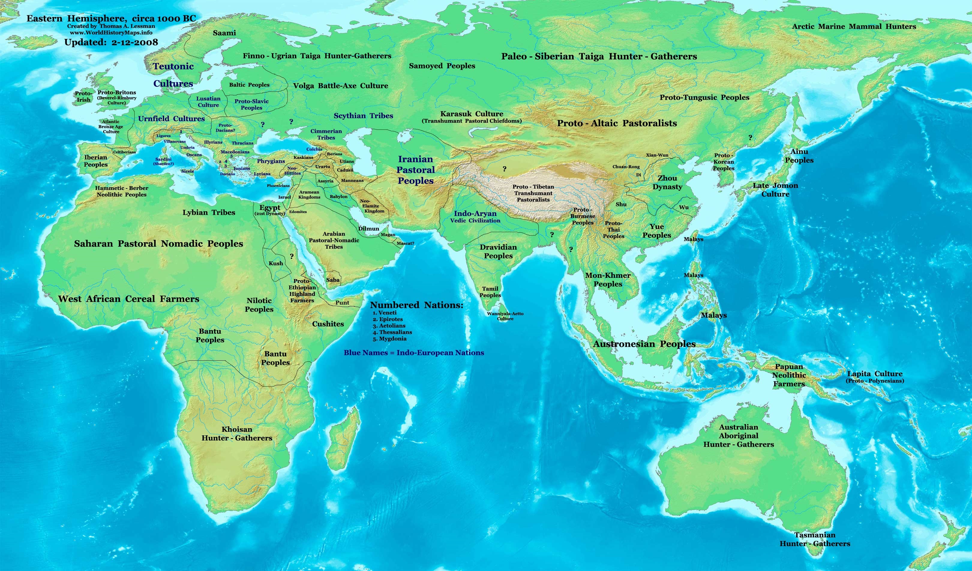
| DescriptionEast-Hem 1000bc.jpg | Eastern Hemisphere in 1000 BC. |
| Origine | self-made (For reference information, see below) |
| Autor | Thomas Lessman (Contact!) |
| Altere versiones | see East-Hem_1000bc.jpg file history on Wikipedia. |
Licentia
- Tu es libere:
- de condivider – de copiar, distribuer e transmitter le obra
- de remixar – de adaptar le obra
- Sub le sequente conditiones:
- attribution – Tu debe dar information appropriate sur le autor, fornir un ligamine al licentia, e indicar si modificationes ha essite apportate. Tu pote facer lo de qualcunque maniera rationabile, ma non in alcun modo que suggere que le licentiator approba te o tu uso del obra.
- condivider equalmente – Si tu altera, transforma o disveloppa le material, tu debe distribuer tu contributiones sub un licentia identic o compatibile con le original.
Map Summary
Original Source URL: http://www.thomaslessman.com/History/images/East-Hem_1000bc.jpg.
This map of the Eastern Hemisphere in 1000 BC was created by Thomas Lessman, based on information from the sources listed below. This map is free for educational use (see Permission info above). When using this map, please mention that it is available for free at www.WorldHistoryMaps.info.
Map Source References
- Remember, sources often conflict with each other. This map is only as accurate as the information that is available to me. To report any errors or to help further this work, please click here, or email Thomas Lessman at talessman@yis.us
References for information contained in this map:
1. Some info derive from the map of the World 1000 BCE, created by User:Briangotts..
2. Zhou (China) borders derive partially from the Huhai.net map of China: 11th to 9th centuries BC.
3. Some information derives from DK Atlas of World History, 2000 edition.
4. Other information is based on various Wikipedia articles and google searches dealing with nations depicted in this map.
Other Maps by Thomas Lessman
| Maps of the eastern hemisphere showing history
Bold dates are available on Wikimedia or Wikipedia. | ||
| Primeval | ||
| Ancient
|
·| 600 BC | 550 BC | 527 BC | 500 BC |
400 BC | ·| 1 AD | 50 AD | 100 AD | 200 AD | 300 AD | | |
| Medieval |
·| 500 AD | 565 AD | 600 AD | 700 AD | | |
| Modern |
·| 1500 AD | · * For historical maps of the whole world, | |
| history links talk edit view | ||
| Annotations InfoField | This image is annotated: View the annotations at Commons |


Legendas
Objectos representate in iste file
representa
Alcun valor sin elemento Wikidata
copyright status anglese
copyrighted anglese
Historia del file
Clicca sur un data/hora pro vider le file como appareva a ille tempore.
| Data/Hora | Miniatura | Dimensiones | Usator | Commento | |
|---|---|---|---|---|---|
| actual | 11:13, 28 septembre 2023 | | 3 240 × 1 903 (1,43 MB) | Notradeuussrs | added Punt |
| 07:15, 9 maio 2008 |  | 3 240 × 1 903 (720 KB) | Talessman | {{Information |Description='''Eastern Hemisphere in 1000 BC'''. |Source=self-made (For reference information, see below) |Author=Thomas Lessman (Contact!) |Date= |Location= |Permission={{self|cc-by-sa-3.0}} |othe |
Uso de iste file
Il non ha paginas que usa iste file.
Uso global de iste file
Le altere wikis sequente usa iste imagine:
- Uso in ar.wikipedia.org
- Uso in en.wikipedia.org
- Chaldea
- 1st millennium BC
- 2nd millennium BC
- 10th century BC
- 1000s BC (decade)
- Indo-Iranians
- Late Bronze Age collapse
- User:Talessman/Maps
- User talk:Talessman/Maps
- List of political entities in the 10th century BC
- User:Benjamin Trovato/sandbox
- Transjordan (region)
- User:Falcaorib/Ancient East Hemisphere
- Uso in fr.wikipedia.org
- Uso in gl.wikipedia.org
- Uso in hy.wikipedia.org
- Uso in hyw.wikipedia.org
- Uso in ku.wikipedia.org
- Uso in ro.wikipedia.org
- Uso in sv.wikipedia.org
- Uso in tr.wikipedia.org
Metadatos
Iste file contine informationes additional, probabilemente addite per le camera digital o scanner usate pro crear o digitalisar lo.
Si le file ha essite modificate ab su stato original, es possibile que alcun detalios non reflecte completemente le file modificate.
| Orientation | Normal |
|---|