Պատկեր:OttomanEmpire1801.jpg
From Wikipedia, the free encyclopedia
Սկզբնական նիշք (1638 × 1296 փիքսել, նիշքի չափը՝ 605 ԿԲ, MIME-տեսակը՝ image/jpeg)
Այս նիշքը տեղադրված է Վիքիպահեստում է և այն կարող է օգտագործվել այլ նախագծերի կողմից։ Վիքիպահեստում նիշքի մասին տեղեկությունների հիմնական մասը ներկայացված է ստորև։
The factual accuracy of this map or the file name is disputed.
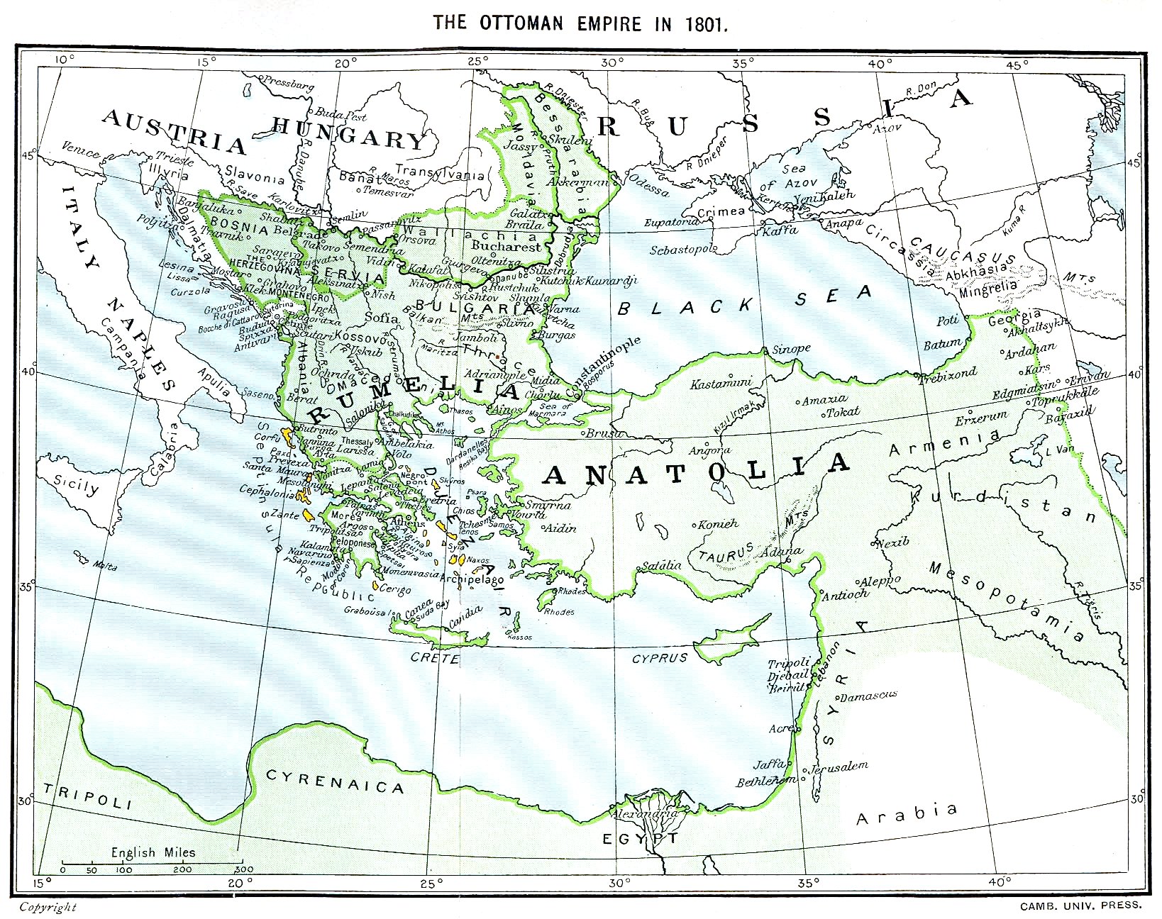
Reason: see file history: The Septinsular Republic includes Ionian Islands, not the Cyclades. Serbia became autonomous 1817. |  |
Ամփոփում
Ottoman Empire (green) and Septinsular Republic (yellow) in 1801.
Արտոնագրում
| Public domainPublic domainfalsefalse |
|
This work is in the public domain in its country of origin and other countries and areas where the copyright term is the author's life plus 70 years or fewer. Note that a few countries have copyright terms longer than 70 years: Mexico has 100 years, Jamaica has 95 years, Colombia has 80 years, and Guatemala and Samoa have 75 years. This image may not be in the public domain in these countries, which moreover do not implement the rule of the shorter term. Honduras has a general copyright term of 75 years, but it does implement the rule of the shorter term. Copyright may extend on works created by French who died for France in World War II (more information), Russians who served in the Eastern Front of World War II (known as the Great Patriotic War in Russia) and posthumously rehabilitated victims of Soviet repressions (more information).
| |
| This file has been identified as being free of known restrictions under copyright law, including all related and neighboring rights. | |
https://creativecommons.org/publicdomain/mark/1.0/PDMCreative Commons Public Domain Mark 1.0falsefalse
Նիշքի պատմություն
Մատնահարեք օրվան/ժամին՝ նիշքի այդ պահին տեսքը դիտելու համար։
| Օր/Ժամ | Մանրապատկեր | Օբյեկտի չափը | Մասնակից | Մեկնաբանություն | |
|---|---|---|---|---|---|
| ընթացիկ | 16:06, 11 հունվարի 2023 | | 1638 × 1296 (605 ԿԲ) | Enyavar | Reverted to version as of 08:56, 11 March 2006 (UTC) --> even if they are wrong, don't change historical maps! |
| 17:48, 3 փետրվարի 2014 |  | 1638 × 1296 (518 ԿԲ) | Spiridon Ion Cepleanu | Some little changes according with the 1801 situation : The Septinsular Rep. includes Ionian Is., not the Cyclades, Serbia became autonomous 1817... | |
| 08:56, 11 Մարտի 2006 |  | 1638 × 1296 (605 ԿԲ) | Julo | Ottoman Empire (green) & Septinsular Republic (yellow) in 1801, on the 19th century map {{PD-old}} category:19th century mapsCategory:Historical maps of the Middle EastCategory:Historical maps of the Balkans[[Category:Historical maps of Africa |
Նիշքի օգտագործում
Հետևյալ էջը հղվում է այս նիշքին՝
Նիշքի համընդհանուր օգտագործում
Հետևյալ այլ վիքիները օգտագործում են այս նիշքը՝
- Օգտագործումը azb.wikipedia.org կայքում
- Օգտագործումը ba.wikipedia.org կայքում
- Օգտագործումը el.wikipedia.org կայքում
- Օգտագործումը en.wikipedia.org կայքում
- Օգտագործումը fr.wikipedia.org կայքում
- Օգտագործումը la.wikipedia.org կայքում
- Օգտագործումը pl.wikipedia.org կայքում
- Օգտագործումը sq.wikipedia.org կայքում
- Օգտագործումը sv.wikipedia.org կայքում
- Օգտագործումը uk.wikipedia.org կայքում
Մետատվյալներ
Նիշքը պարունակում է ընդարձակ տվյալները, հավանաբար ավելացված թվային լուսանկարչական ապարատի կամ սկաների կողմից, որոնք օգտագործվել են նկարը ստեղծելու կամ թվայնացնելու համար։
Եթե նիշքը ձևափոխվել է ստեղծումից ի վեր, ապա որոշ տվյալները կարող են չհամապատասխանել ձևափոխված նիշքին։
| Orientation | Normal |
|---|---|
| Horizontal resolution | 200 dpi |
| Vertical resolution | 200 dpi |
| Software used | Adobe Photoshop 7.0 |
| File change date and time | 14:37, 28 Սեպտեմբերի 2003 |
| Color space | Uncalibrated |