Պատկեր:Erzurum_districts.png
From Wikipedia, the free encyclopedia
Նախադիտման չափ՝ 776 × 600 պիքսել։ Այլ թույլտվությաններ: 311 × 240 պիքսել | 621 × 480 պիքսել | 994 × 768 պիքսել | 1056 × 816 պիքսել.
Սկզբնական նիշք (1056 × 816 փիքսել, նիշքի չափը՝ 38 ԿԲ, MIME-տեսակը՝ image/png)
Այս նիշքը տեղադրված է Վիքիպահեստում է և այն կարող է օգտագործվել այլ նախագծերի կողմից։ Վիքիպահեստում նիշքի մասին տեղեկությունների հիմնական մասը ներկայացված է ստորև։
Ամփոփում
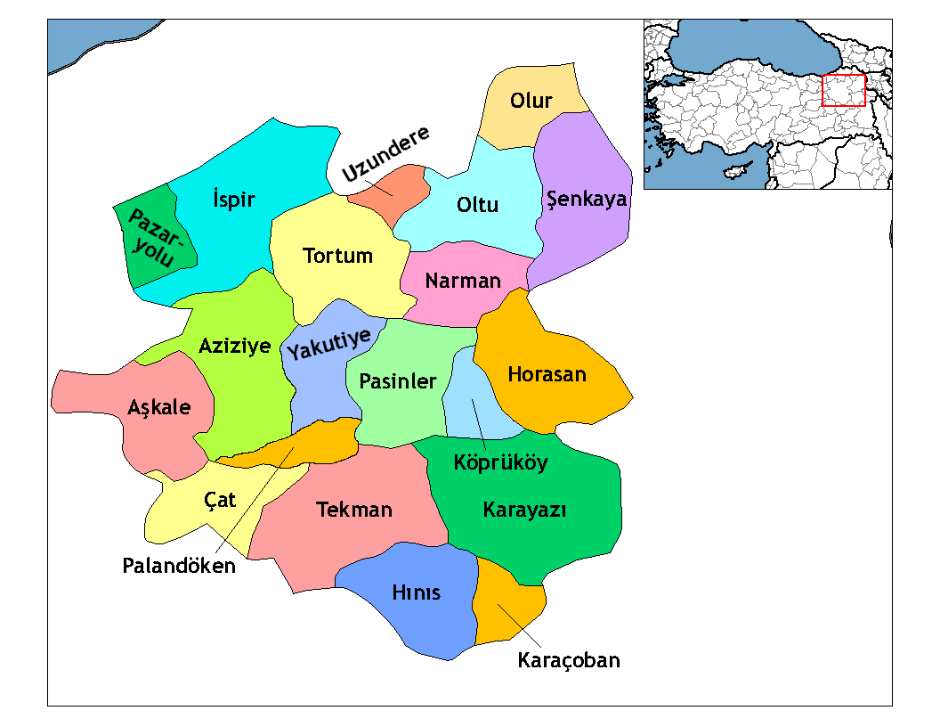
| ՆկարագրումErzurum districts.png | Map of the districts of Erzurum province in Turkey. Created by Rarelibra 19:53, 1 December 2006 (UTC) for public domain use, using MapInfo Professional v8.5 and various mapping resources. Edited by One Homo Sapiens Corrected text where İ,Ş,ı,ğ,or ş occurs in name. Source: [statoids-com]. Increased font size and enhanced color differences among adjacent districts. |
| Թվական | 1 Դեկտեմբեր 2006 (original upload date) |
| Աղբյուր | No machine-readable source provided. Own work assumed (based on copyright claims). |
| Հեղինակ | No machine-readable author provided. Rarelibra assumed (based on copyright claims). |
Արտոնագրում
| Public domainPublic domainfalsefalse |
| I, the copyright holder of this work, release this work into the public domain. This applies worldwide. In some countries this may not be legally possible; if so: I grant anyone the right to use this work for any purpose, without any conditions, unless such conditions are required by law. |
Captions
Add a one-line explanation of what this file represents
Erzurum siyasi haritası
Items portrayed in this file
պատկերված
1 Դեկտեմբերի 2006
Նիշքի պատմություն
Մատնահարեք օրվան/ժամին՝ նիշքի այդ պահին տեսքը դիտելու համար։
| Օր/Ժամ | Մանրապատկեր | Օբյեկտի չափը | Մասնակից | Մեկնաբանություն | |
|---|---|---|---|---|---|
| ընթացիկ | 02:52, 18 Ապրիլի 2009 | | 1056 × 816 (38 ԿԲ) | One Homo Sapiens | Added Aziziye, Palandöken and Yakutiye, that replaced Erzurum merkezi and Ilıca districts. Source: << www.erzurum.gov.tr >> |
| 22:20, 28 Դեկտեմբերի 2008 |  | 1056 × 816 (41 ԿԲ) | One Homo Sapiens | Corrected text where İ,Ş,ı,ğ,or ş occurs in name. Source: [statoids-com]. Increased font size and enhanced color differences among adjacent districts. | |
| 19:53, 1 Դեկտեմբերի 2006 |  | 1056 × 816 (35 ԿԲ) | Rarelibra | Map of the districts of Erzurum province in Turkey. Created by ~~~~ for public domain use, using MapInfo Professional v8.5 and various mapping resources. |
Նիշքի օգտագործում
Հետևյալ 2 էջերը հղվում են այս նիշքին՝
Նիշքի համընդհանուր օգտագործում
Հետևյալ այլ վիքիները օգտագործում են այս նիշքը՝
- Օգտագործումը ar.wikipedia.org կայքում
- Օգտագործումը arz.wikipedia.org կայքում
- Օգտագործումը ast.wikipedia.org կայքում
- Օգտագործումը azb.wikipedia.org կայքում
- Օգտագործումը ba.wikipedia.org կայքում
- Օգտագործումը bs.wikipedia.org կայքում
- Օգտագործումը ca.wikipedia.org կայքում
- Օգտագործումը cs.wikipedia.org կայքում
- Օգտագործումը de.wikipedia.org կայքում
- Օգտագործումը diq.wikipedia.org կայքում
- Օգտագործումը en.wikipedia.org կայքում
Տեսնել այս նիշքի ավելի համընդհանուր օգտագործումը:
Ստացված է «https://hy.wikipedia.org/wiki/Պատկեր:Erzurum_districts.png» էջից