Map Graph

Roraima-hegy

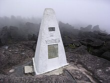
A Roraima-hegy a Pacaraima-hegység tepuiláncának legmagasabb hegye. A hegy első leírása az angol felfedező Walter Raleigh-től származik 1596-ból. A 31 km² területű táblahegy, melyet minden oldalról 400 méteres sziklafalak határolják, Venezuela, Brazília és Guyana hármashatárán található.

Read article
Fájl:Roraima3_(79).JPGFájl:Tepuy_Roraima_topographic_map-fr.svgFájl:Tepuy_vegetation_-_Roraima_Venezuela.JPGFájl:Oreophrynella_quelchii.jpgFájl:Roraima-Tepui_Wand.jpgFájl:Triple_Point,_Mount_Roraima.jpgFájl:Roraima_Maverick_Stone3.jpgFájl:Los_Jacuzzis.jpgFájl:Mount_Roraima,_Venezuela_(12372333523).jpgFájl:Maverick.JPGFájl:Pared_del_Roraima.jpgFájl:Excursionistas_ascendiendo_Roraima.jpgFájl:Utricularia_campbelliana.JPGFájl:Bothriopsis_taeniata2.JPGFájl:Mount_Roraima,_Venezuela_(12372051123).jpgFájl:Roraima_Elefante.jpgFájl:Doyle_-_Le_Monde_perdu.djvu
Nearby Places
Thumbnail
Guyanai-masszívum