Found in articles
Datoteka:LocationLesotho.png
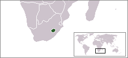
Location map for the Lesotho. Originally created for English Wikipedia by Vardion. English determination method: SHA-1
Datoteka:Lesotho location map.svg
Karte: * N: 21.8° S * S: 35.2° S * W: 16.0° O * O: 33.2° O {{e File:Lesotho_Locator.png licensed with Cc-by-sa-3.0,2.5,2.0,1.0, GFDL 2008-03-06T18:16:28Z
Datoteka:District of lesotho AR.PNG
|Description={{de|Positionskarte von [[:de:Lesotho|Lesotho]]}} Quadratische Plattkarte. {{en|Location map of [[:en:Lesotho|Lesotho]]}} Equirectangular projection
Datoteka:Lesotho South Africa Locator.png
choice. This image is a derivative work of the following images: File:LocationLesotho.svg licensed with Cc-by-sa-2.5,2.0,1.0, Cc-by-sa-3.0-migrated, GFDL
Datoteka:Lesotho regions map ru.png
|credit=[[User:Digr]] |captureDate=27/03/2010 |location=Lesotho |source=base on [[:wts:Image:Lesotho regions map (Import from wikitravel.org/shared)
