चित्र:Port_of_Dover_-_view_from_the_White_Cliffs-4101-03.jpg
From Wikipedia, the free encyclopedia
मूल चित्र ((7,785 × 3,051 पिक्सेल, फ़ाइल का आकार: 3.14 MB, MIME प्रकार: image/jpeg))
|
|
यह फ़ाइल विकिमेडिया कॉमन्स से है। वहाँ पर इसका विवरण पृष्ठ निम्नोक्त है। कॉमन्स मुक्त लाइसेंसों के अंतर्गत उपलब्ध मीडिया फ़ाइलों का संग्रह है। आप भी इसमें मदद कर सकते हैं। |
सारांश
| विवरणPort of Dover - view from the White Cliffs-4101-03.jpg |
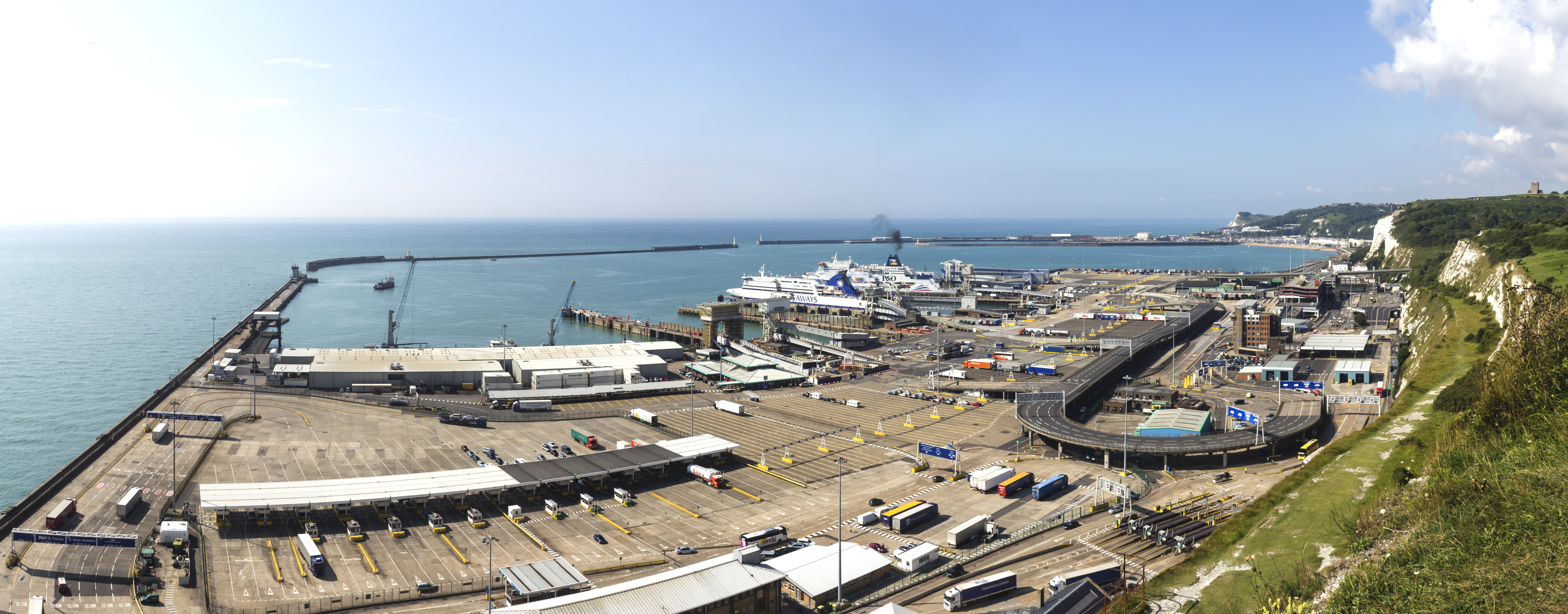
English: Port of Dover - view from the White Cliffs Deutsch: Hafen von Dover. Blick herab von den weißen Klippen von Dover |
|||||||||||||||||
| दिनांक | ||||||||||||||||||
| स्रोत | अपना कार्य | |||||||||||||||||
| लेखक |
creator QS:P170,Q108103612 |
|||||||||||||||||
| दूसरे संस्करण |
|
|||||||||||||||||
| श्रेय (required by the license) InfoField | © Raimond Spekking / CC BY-SA 4.0 (via Wikimedia Commons) |
|||||||||||||||||
InfoField | © Raimond Spekking | |||||||||||||||||


| कैमरा स्थान | ५१° ०७′ ५२.२४″ N, १° २०′ २८.५९″ E | यह और अन्य आसपास की छवियों यहां पर देखें: ओपन स्ट्रीट मैप |
|---|

|
NOTE: This image is a panorama consisting of 3 frames that were merged or stitched in PanoramaStudio. As a result, this image necessarily underwent some form of digital manipulation. These manipulations may include blending, blurring, cloning, and colour and perspective adjustments. As a result of these adjustments, the image content may be slightly different from reality at the points where multiple images were combined. This manipulation is often required due to lens, perspective, and parallax distortions.
Boarisch | български | dansk | Deutsch | Zazaki | Ελληνικά | English | Canadian English | British English | Esperanto | español | eesti | suomi | français | hrvatski | magyar | italiano | 日本語 | 한국어 | македонски | മലയാളം | Nederlands | polski | português | русский | sicilianu | slovenščina | svenska | Türkçe | українська | العربية | 中文 | +/− |
लाइसेंस
I have published this image as author under the Creative-Commons-Licence CC BY-SA 4.0.. This means that free online usage outside of Wikimedia projects under the following terms of licence is possible:
- The image is credited with "© Raimond Spekking / CC BY-SA 4.0 (via Wikimedia Commons)"
For all other kind of usages (books, journales, flyers, etc.) click on the following button. You will get all information needed.
I would be happy to receive a specimen copy or the URL of the website where the image is used.
Please write an email to raimond.spekking@gmail.com (GPG encrypted emails are welcome: Key-ID: 0xB12BE7A6), if you
- need the image in a higher resolution
- need my postal address for sending a specimen copy
- have further questions to the terms of licence
- आप खुलकर:
- बाँट सकते हैं – रचना की प्रतिलिपि बना सकते हैं, बाँँट सकते हैं और संचारित कर सकते हैं
- रीमिक्स कर सकते हैं – कार्य को अनुकूलित कर सकते हैं
- निम्नलिखित शर्तों के अंतर्गत:
- श्रेय – यह अनिवार्य है कि आप यथोचित श्रेय प्रदान करें, लाइसेंस की कड़ी प्रदान करें, और अगर कोई बदलाव हुए हों तो उन्हें इंगित करें। आप ऐसा किसी भी उचित तरीके से कर सकते हैं, लेकिन किसी भी तरह उससे यह नहीं संकेत नहीं किया जाना चाहिए कि लाइसेंसधारी द्वारा आपको अथवा आपके इस प्रयोग का समर्थन किया जा रहा हो।
- समानसांझा – अगर आप इस रचना में कोई बदलाव करते हैं या इसपर आधारित कुछ रचित करते हैं तो आप अपने योगदान को सिर्फ इसी या इसके सामान किसी लाइसेंस के अंतर्गत बाँट सकते हैं।
| Annotations InfoField | This image is annotated: View the annotations at Commons |

Captions
Items portrayed in this file
चित्रण
Port of Dover अंग्रेज़ी
Raimond Spekking अंग्रेज़ी
source of file अंग्रेज़ी
original creation by uploader अंग्रेज़ी
coordinates of the point of view अंग्रेज़ी
51°7'52.24199"N, 1°20'28.59421"E
७ अगस्त 2014
location of the point of view अंग्रेज़ी
White Cliffs of Dover अंग्रेज़ी
चित्र का इतिहास
फ़ाइलका पुराना अवतरण देखने के लिये दिनांक/समय पर क्लिक करें।
| दिनांक/समय | थंबनेल | आकार | सदस्य | प्रतिक्रिया | |
|---|---|---|---|---|---|
| वर्तमान | 19:04, 6 नवम्बर 2014 | 7,785 × 3,051 (3.14 MB) | Raymond | User created page with UploadWizard |
चित्र का उपयोग
निम्नलिखित पन्ने इस चित्र से जुडते हैं :
चित्र का वैश्विक उपयोग
इस चित्र का उपयोग इन दूसरे विकियों में किया जाता है:
- bn.wikipedia.org पर उपयोग
- ceb.wikipedia.org पर उपयोग
- de.wikipedia.org पर उपयोग
- de.wiktionary.org पर उपयोग
- en.wikipedia.org पर उपयोग
- eu.wikipedia.org पर उपयोग
- fi.wikipedia.org पर उपयोग
- fr.wikipedia.org पर उपयोग
- gv.wikipedia.org पर उपयोग
- hak.wikipedia.org पर उपयोग
- he.wikipedia.org पर उपयोग
- lt.wikipedia.org पर उपयोग
- no.wikipedia.org पर उपयोग
- pt.wiktionary.org पर उपयोग
- sr.wikipedia.org पर उपयोग
- ta.wikipedia.org पर उपयोग
- www.wikidata.org पर उपयोग
- yi.wikipedia.org पर उपयोग
- zh.wikipedia.org पर उपयोग
- zh.wiktionary.org पर उपयोग
मेटाडेटा
इस फ़ाइल में अतिरिक्त जानकारी मौजूद है, जो शायद इसे बनाने या डिजिटाइज़ करने के लिए उपयुक्त डिजिटल कैमरा या फिर स्कैनर द्वारा जोड़ा गया हो।
अगर चित्र को इसके मूल रूप से बदला गया है, शायद कुछ जानकारी इसके वर्तमान स्थिति से संबंधित न हो।
| चित्र शीर्षक |
|
|---|---|
| लेखक | Raimond Spekking |
| कॉपीराइट के धारक | |
| डेटा की सृष्टि का दिनांक और समय | 09:14, 7 अगस्त 2014 |
| अक्षांश | 51° 7′ 52.24″ N |
| रेखांश | 1° 20′ 28.59″ E |
| अल्टिट्यूड | 25 meters समुद्र स्तर से ऊपर |
| क्षैतिज रेसोल्यूशन | 72 dpi |
| वर्टिकल रिज़ोल्यूशन | 72 dpi |
| फ़ाइल बदलाव दिनांक और समय | 09:14, 7 अगस्त 2014 |
| Y और C का स्थान | केंद्रित |
| Exif संस्करण | 2.3 |
| डिजिटाइज़िंग का दिनांक और समय | 09:14, 7 अगस्त 2014 |
| हर घटक का मतलब |
|
| समर्थित Flashpix संस्करण | 1 |
| रंग स्थान | कैलिब्रेट नहीं गया |
| GPS समय (एटोमिक क्लॉक) | 08:14 |
| चित्रके दिशा का संदर्भ | असली दिशा |
| चित्र की दिशा | 213.62 |
| जियोडेटिक सर्वे डाटा इस्तेमाल किया गया | WGS-84 |
| अक्षांश लक्ष्य | 51° 7′ 34.01″ N |
| लक्ष्य का रेखांश | 1° 20′ 9.28″ E |
| GPS दिनांक | 7 अगस्त 2014 |
| GPS टॅग अवतरण | 2.2.0.0 |
| संपर्क जानकारी | raimond.spekking@gmail.com
https://de.wikipedia.org/wiki/Benutzer:Raymond
|
| लघु शीर्षक |
|
| लेखक | Raimond Spekking |
| दर्ज़ा (5 से) | 5 |
| देश के लिए कोड दिखाया गया हे | GBR |
| शहर के एक जगह दिखाया गया हे | Dover District |
| शहर दिखया गया हे | Dover |
| देश दिखया गया हे | Großbritannien |
| प्रांत या राज्य दिखाया गया हे | England |
| आईआईएम संस्करण | 4 |