File:Colonisation_1885.png
From Wikipedia, the free encyclopedia
मूल चित्र ((1,200 × 526 पिक्सेल, फ़ाइल का आकार: 206 KB, MIME प्रकार: image/png))
|
|
यह फ़ाइल विकिमेडिया कॉमन्स से है। वहाँ पर इसका विवरण पृष्ठ निम्नोक्त है। कॉमन्स मुक्त लाइसेंसों के अंतर्गत उपलब्ध मीडिया फ़ाइलों का संग्रह है। आप भी इसमें मदद कर सकते हैं। |
| References for this description (or part of this) or for the depiction in the file are not provided. |
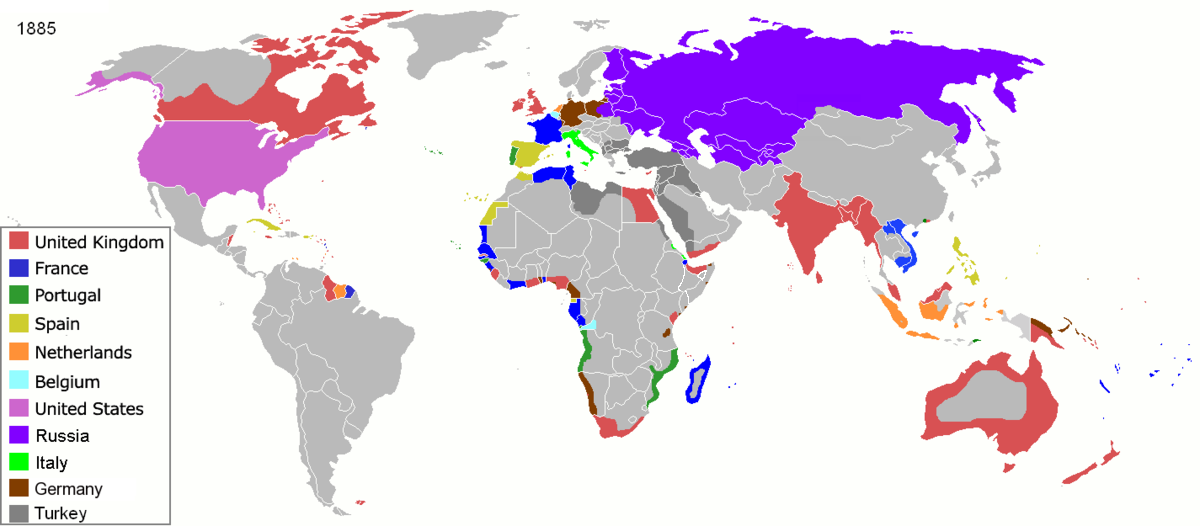
| विवरणColonisation 1885.png |
Map of major world powers by year, derived from public domain animated map on wikipedia.
As the orriginal licence of the animation was Public Domain, this image which has been derived from it is too:
|
|||||||||||||||||||
| दिनांक | ||||||||||||||||||||
| स्रोत | public domain animated map by ArdadN here | |||||||||||||||||||
| लेखक | ArdadN | |||||||||||||||||||
.jpg)
._LOC_2001620596.jpg)

|
This historical map image could be re-created using vector graphics as an SVG file. This has several advantages; see Commons:Media for cleanup for more information. If an SVG form of this image is available, please upload it and afterwards replace this template with
{{vector version available|new image name}}.
It is recommended to name the SVG file “Colonisation 1885.svg”—then the template Vector version available (or Vva) does not need the new image name parameter. |
Captions
२२ मार्च 2007
media type अंग्रेज़ी
image/png
checksum अंग्रेज़ी
831fd10c262a996a3291205f48ebb3278f0cca4d
data size अंग्रेज़ी
२,१०,६२६ बाइट
५२६ पिक्सल
width अंग्रेज़ी
१,२०० पिक्सल
चित्र का इतिहास
फ़ाइलका पुराना अवतरण देखने के लिये दिनांक/समय पर क्लिक करें।
| दिनांक/समय | थंबनेल | आकार | सदस्य | प्रतिक्रिया | |
|---|---|---|---|---|---|
| वर्तमान | 09:05, 8 नवम्बर 2021 | | 1,200 × 526 (206 KB) | Randomastwritter | jubaland |
| 09:52, 5 अप्रैल 2020 |  | 1,200 × 526 (206 KB) | Ориенталист | South Sakhalin was part of Russia in 1885 | |
| 11:17, 2 मई 2015 |  | 1,425 × 625 (49 KB) | Chrischerf | German Empire and colonies in 1885; Sudan under control of the Mahdi | |
| 02:57, 3 अगस्त 2014 |  | 1,425 × 625 (54 KB) | Alvin Lee | correcting the boundaries of Russia and China | |
| 13:54, 3 नवम्बर 2013 |  | 1,425 × 625 (78 KB) | McZusatz | Reverted to version as of 00:22, 24 January 2011 [corrupt file?] | |
| 15:24, 3 नवम्बर 2012 |  | 1,425 × 625 (67 KB) | Franco310397 | Spanish presence in Micronesia (Oceania) included in the Captaincy General of the Philippines. In the Caroline Islands and the Mariana Islands. | |
| 00:22, 24 जनवरी 2011 |  | 1,425 × 625 (78 KB) | Micsha~commonswiki | Reverted to version as of 02:17, 3 May 2010 | |
| 00:22, 24 जनवरी 2011 |  | 506 × 326 (85 KB) | Micsha~commonswiki | Only Africa; includes map key | |
| 02:17, 3 मई 2010 |  | 1,425 × 625 (78 KB) | Kieran4 | slight edit | |
| 02:14, 3 मई 2010 |  | 1,425 × 625 (78 KB) | Kieran4 | Correct Dutch East INdies |
चित्र का उपयोग
इस चित्र से कोई पन्ने नहीं जुड़ते
चित्र का वैश्विक उपयोग
इस चित्र का उपयोग इन दूसरे विकियों में किया जाता है:
- am.wikipedia.org पर उपयोग
- de.wikipedia.org पर उपयोग
- en.wikipedia.org पर उपयोग
- es.wikipedia.org पर उपयोग
- fr.wikipedia.org पर उपयोग
- he.wikipedia.org पर उपयोग
- oc.wikipedia.org पर उपयोग
- sk.wikipedia.org पर उपयोग
मेटाडेटा
इस फ़ाइल में अतिरिक्त जानकारी मौजूद है, जो शायद इसे बनाने या डिजिटाइज़ करने के लिए उपयुक्त डिजिटल कैमरा या फिर स्कैनर द्वारा जोड़ा गया हो।
अगर चित्र को इसके मूल रूप से बदला गया है, शायद कुछ जानकारी इसके वर्तमान स्थिति से संबंधित न हो।
| क्षैतिज रेसोल्यूशन | 47.24 dpc |
|---|---|
| वर्टिकल रिज़ोल्यूशन | 47.24 dpc |
| PNG फ़ाइल टिप्पणी | |
| प्रयुक्त सॉफ़्टवेयर |
|