File:Barents_sp.png
From Wikipedia, the free encyclopedia
इससे बड़ा रेसोल्यूशन उपलब्ध नहीं हैं।
Barents_sp.png ((655 × 599 पिक्सेल, फ़ाइल का आकार: 170 KB, MIME प्रकार: image/png))
|
|
यह फ़ाइल विकिमेडिया कॉमन्स से है। वहाँ पर इसका विवरण पृष्ठ निम्नोक्त है। कॉमन्स मुक्त लाइसेंसों के अंतर्गत उपलब्ध मीडिया फ़ाइलों का संग्रह है। आप भी इसमें मदद कर सकते हैं। |
सारांश
| विवरणBarents sp.png |
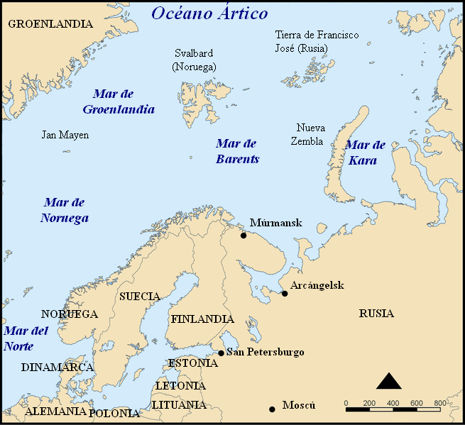
Español: Situación del Mar de Barents.
Mapa del mar de Barents en español. Barents sea map in Spanish. |
| दिनांक | |
| स्रोत | Modified from Image:Barents sea map blank.png |
| लेखक | Alfanje |
| दूसरे संस्करण |
[सम्पादन]
|


This picture was modified from Barents_sea_map.png, bellow you'll find the tag and the information on the previous image
This map shows the location of the Barents Sea north of Russia and Norway, and the surrounding seas and islands.
Created by NormanEinstein, November 25, 2005.
Modified and blanked by historicair 22:27, 28 February 2006 (UTC)
This map was improved or created by the Wikigraphists of the Graphic Lab (fr). You can propose images to clean up, improve, create or translate as well. |
मैं, इस कार्य का/की कॉपीराइट धारक, इसे निम्न लाइसेंसों के अंतर्गत प्रकाशित करता/करती हूँ:

|
इस दस्तावेज़ को Free Software Foundation द्वारा प्रकाशित GNU मुक्त प्रलेख लाइसेंस के संस्करण 1.2 या नए (बिना किसी अपरिवर्तनीय अनुभागों और अगले या पिछले आवरण के टेक्स्ट के) के अंतर्गत प्रतिलिपि बनाने, बाँटने और/या बदलने की अनुमति प्रदान की जाती है। इस लाइसेंस की एक प्रतिलिपि GNU मुक्त प्रलेख लाइसेंस नामक अनुभाग में शामिल है।http://www.gnu.org/copyleft/fdl.htmlGFDLGNU Free Documentation Licensetruetrue |
| इस फ़ाइल को क्रिएटिव कॉमन्स श्रेय-समानसांझा 3.0 अनरिपोर्टेड लाइसेंस के अंतर्गत लाइसेंस किया गया है। | ||
| ||
| This licensing tag was added to this file as part of the GFDL licensing update.http://creativecommons.org/licenses/by-sa/3.0/CC BY-SA 3.0Creative Commons Attribution-Share Alike 3.0truetrue |
आप अपना पसंद का लाइसेंस चुन सकते हैं।
Captions
Add a one-line explanation of what this file represents
Items portrayed in this file
चित्रण
१७ मई 2006
media type अंग्रेज़ी
image/png
checksum अंग्रेज़ी
0224d3532cf3d6e1077be653cf4808bbb70ce00d
data size अंग्रेज़ी
१,७४,११२ बाइट
५९९ पिक्सल
width अंग्रेज़ी
६५५ पिक्सल
चित्र का इतिहास
फ़ाइलका पुराना अवतरण देखने के लिये दिनांक/समय पर क्लिक करें।
| दिनांक/समय | थंबनेल | आकार | सदस्य | प्रतिक्रिया | |
|---|---|---|---|---|---|
| वर्तमान | 15:32, 17 मई 2006 | | 655 × 599 (170 KB) | Alfanje~commonswiki | Mapa del mar de Barents en español. Barents sea map in Spanish. Modified from Image:Barents sea blank map.png |
चित्र का उपयोग
इस चित्र से कोई पन्ने नहीं जुड़ते
चित्र का वैश्विक उपयोग
इस चित्र का उपयोग इन दूसरे विकियों में किया जाता है:
- ca.wikipedia.org पर उपयोग
- es.wikipedia.org पर उपयोग
- eu.wikipedia.org पर उपयोग
- gl.wikipedia.org पर उपयोग
- pl.wiktionary.org पर उपयोग
"https://hi.wikipedia.org/wiki/चित्र:Barents_sp.png" से प्राप्त