File:Arab_world_map_1154.png
From Wikipedia, the free encyclopedia
इससे बड़ा रेसोल्यूशन उपलब्ध नहीं हैं।
Arab_world_map_1154.png ((342 × 336 पिक्सेल, फ़ाइल का आकार: 76 KB, MIME प्रकार: image/png))
|
|
यह फ़ाइल विकिमेडिया कॉमन्स से है। वहाँ पर इसका विवरण पृष्ठ निम्नोक्त है। कॉमन्स मुक्त लाइसेंसों के अंतर्गत उपलब्ध मीडिया फ़ाइलों का संग्रह है। आप भी इसमें मदद कर सकते हैं। |
सारांश
| विवरणArab world map 1154.png |
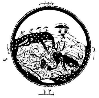
English: Copy form 1500 of a map drawn by the Arab geographer Idrisi in 1154. South on top. Africa is shown in the tradition of Ptolemy: The Nile flows out of two lakes, probably representing Lake Victoria and Lake Edward, and unites in a third lake, probably representing Lake Albert.
Deutsch: Weltkarte des arabischen Geografen Idrisi (Original 1154, Kopie um 1500). Süden ist oben. Darstellung Afrikas in der Tradition Claudius Ptolemäus: Der Nil entfließt zwei großen Seen, wohl Viktoriasee und Eduardsee entsprechend. Der See, in dem sie sich vereinigen, entpricht wohl dem Albertsee. |
| दिनांक | |
| स्रोत | Andreas Speer, Lydia Wegener: "Wissen über Grenzen: Arabisches wissen und lateinisches Mittelalter", 2006, Walter de Gruyter |
| लेखक | Idrisi (Arab geographer), shot & upload Ulamm (talk) 11:48, 1 November 2008 (UTC) |
लाइसेंस
| Public domainPublic domainfalsefalse |
|
This work is in the public domain in its country of origin and other countries and areas where the copyright term is the author's life plus 100 years or fewer. | |
| इस फ़ाइल को कॉपीराइट कानूनों के अंतर्गत सभी संबंधित अधिकारों समेत ज्ञात सीमाओं से मुक्त पहचाना गया है। | |
https://creativecommons.org/publicdomain/mark/1.0/PDMCreative Commons Public Domain Mark 1.0falsefalse
Captions
Add a one-line explanation of what this file represents
Items portrayed in this file
चित्रण
1154
media type अंग्रेज़ी
image/png
checksum अंग्रेज़ी
c044374b79d13112ba18c2117ebf2e9d8a997c07
data size अंग्रेज़ी
७७,३५४ बाइट
३३६ पिक्सल
width अंग्रेज़ी
३४२ पिक्सल
चित्र का इतिहास
फ़ाइलका पुराना अवतरण देखने के लिये दिनांक/समय पर क्लिक करें।
| दिनांक/समय | थंबनेल | आकार | सदस्य | प्रतिक्रिया | |
|---|---|---|---|---|---|
| वर्तमान | 11:48, 1 नवम्बर 2008 | | 342 × 336 (76 KB) | Ulamm | {{Information |Description={{en|1=Map drawn by the Arab geographer Idrisi, south on top. Africa is shown in the tradition of Ptolemy: The Nile flows out of two lakes, probably representing Lake Victoria and Lake Albert, and unites in a third lake, probabl |
चित्र का उपयोग
इस चित्र से कोई पन्ने नहीं जुड़ते