File:Wawa_footprint_2012-07.png
From Wikipedia, the free encyclopedia
इस पूर्वावलोकन का आकार: 548 × 599 पिक्सेल। दूसरे रेसोल्यूशन्स: 220 × 240 पिक्सेल | 439 × 480 पिक्सेल | 644 × 704 पिक्सेल।
मूल चित्र ((644 × 704 पिक्सेल, फ़ाइल का आकार: 138 KB, MIME प्रकार: image/png))
|
|
यह फ़ाइल विकिमेडिया कॉमन्स से है। वहाँ पर इसका विवरण पृष्ठ निम्नोक्त है। कॉमन्स मुक्त लाइसेंसों के अंतर्गत उपलब्ध मीडिया फ़ाइलों का संग्रह है। आप भी इसमें मदद कर सकते हैं। |
सारांश


| Point Maps
══▻ FAQ ◅══ ══▻ Create your own ◅══ |
लाइसेंस
इस फ़ाइल को क्रिएटिव कॉमन्स श्रेय-समानसांझा 3.0 अनरिपोर्टेड लाइसेंस के अंतर्गत लाइसेंस किया गया है।
- आप खुलकर:
- बाँट सकते हैं – रचना की प्रतिलिपि बना सकते हैं, बाँँट सकते हैं और संचारित कर सकते हैं
- रीमिक्स कर सकते हैं – कार्य को अनुकूलित कर सकते हैं
- निम्नलिखित शर्तों के अंतर्गत:
- श्रेय – यह अनिवार्य है कि आप यथोचित श्रेय प्रदान करें, लाइसेंस की कड़ी प्रदान करें, और अगर कोई बदलाव हुए हों तो उन्हें इंगित करें। आप ऐसा किसी भी उचित तरीके से कर सकते हैं, लेकिन किसी भी तरह उससे यह नहीं संकेत नहीं किया जाना चाहिए कि लाइसेंसधारी द्वारा आपको अथवा आपके इस प्रयोग का समर्थन किया जा रहा हो।
- समानसांझा – अगर आप इस रचना में कोई बदलाव करते हैं या इसपर आधारित कुछ रचित करते हैं तो आप अपने योगदान को सिर्फ इसी या इसके सामान किसी लाइसेंस के अंतर्गत बाँट सकते हैं।
मूल अपलोड लॉग
This image is a derivative work of the following images:
- File:USA_Pennsylvania_location_map.svg licensed with Cc-by-3.0, GFDL
- 2009-07-05T11:11:22Z Alexrk2 1201x805 (429769 Bytes) == Beschreibung == {{Information |Description= {{de|Positionskarte von [[:de:Pennsylvania|Pennsylvania]], [[:de:USA|USA]]}} Quadratische Plattkarte, N-S-Streckung 130.0 %. Geographische Begrenzung der Karte: * N: 42.7° N * S
- File:USA_New_Jersey_location_map.svg licensed with Cc-by-3.0, GFDL
- 2009-06-17T19:59:27Z Alexrk2 839x1560 (259806 Bytes) enh
- 2009-06-13T18:01:16Z Alexrk 839x1560 (198653 Bytes) fixed SVG bug
- 2009-06-13T17:46:17Z Alexrk 839x1560 (246056 Bytes) == Beschreibung == {{Information |Description= {{de|Positionskarte von [[:de:New Jersey|New Jersey]], [[:de:USA|USA]]}} Quadratische Plattkarte, N-S-Streckung 130.0 %. Geographische Begrenzung der Karte: * N: 41.6° N * S: 38
- File:USA_Maryland_location_map.svg licensed with Cc-by-3.0, GFDL
- 2009-06-22T11:30:38Z Alexrk2 1200x764 (463352 Bytes) fixed border
- 2009-06-22T11:23:05Z Alexrk2 1200x764 (459278 Bytes) crop height
- 2009-06-22T11:03:54Z Alexrk2 1201x955 (455501 Bytes) renderer bug
- 2009-06-22T10:42:06Z Alexrk2 800x636 (318450 Bytes) == Beschreibung == {{Information |Description= {{de|Positionskarte von [[:de:Maryland|Maryland]], [[:de:USA|USA]]}} Quadratische Plattkarte, N-S-Streckung 130.0 %. Geographische Begrenzung der Karte: * N: 40.3° N * S: 37.3°
- File:USA_New_York_location_map.svg licensed with Cc-by-3.0, GFDL
- 2009-06-10T11:28:20Z NordNordWest 1572x1277 (597043 Bytes) {{Information |Description= {{de|Positionskarte vom Bundesstaat [[:de:New York (Bundesstaat)|New York]], [[:de:USA|USA]]}} Quadratische Plattkarte, N-S-Streckung 135 %. Geographische Begrenzung der Karte: * N: 45.3° N * S: 4
- File:USA_Virginia_location_map.svg licensed with Cc-by-3.0, GFDL
- 2009-07-06T18:02:25Z Alexrk2 1500x964 (963271 Bytes) resize
- 2009-06-26T16:42:40Z Alexrk2 1201x772 (966691 Bytes) == Beschreibung == {{Information |Description= {{de|Positionskarte von [[:de:Virginia|Virginia]], [[:de:USA|USA]]}} Quadratische Plattkarte, N-S-Streckung 130.0 %. Geographische Begrenzung der Karte: * N: 40.2° N * S: 35.8°
- File:USA_West_Virginia_location_map.svg licensed with Cc-by-3.0, GFDL
- 2009-07-03T15:31:49Z Alexrk2 1201x1118 (535137 Bytes) == Beschreibung == {{Information |Description= {{de|Positionskarte von [[:de:West Virginia|West Virginia]], [[:de:USA|USA]]}} Quadratische Plattkarte, N-S-Streckung 130.0 %. Geographische Begrenzung der Karte: * N: 40.8° N *
- File:USA_Florida_location_map.svg licensed with Cc-by-3.0
- 2008-12-15T20:25:08Z Sting 1132x1096 (591820 Bytes) Counties boundaries: thinner strokes
- 2008-12-15T19:49:40Z Sting 1132x1096 (591829 Bytes) == Summary == {{Location|27|45|00|N|83|49|30|W|scale:4000000}} {{Information |Description={{en|Blank administrative map of the State of [[:en:Florida|Florida]], [[:en:United States|USA]], for geo-location purpose, with count
- File:USA_Connecticut_location_map.svg licensed with Cc-by-3.0, GFDL
- 2009-06-25T19:16:48Z Alexrk2 800x678 (154250 Bytes) renderer bug
- 2009-06-25T19:14:39Z Alexrk2 800x678 (155149 Bytes) == Beschreibung == {{Information |Description= {{de|Positionskarte von [[:de:Connecticut|Connecticut]], [[:de:USA|USA]]}} Quadratische Plattkarte, N-S-Streckung 130.0 %. Geographische Begrenzung der Karte: * N: 42.3° N * S:
- File:USA_North_Carolina_location_map.svg licensed with Cc-by-3.0, GFDL
- 2010-04-25T12:44:25Z Alexrk2 1400x849 (1201046 Bytes) enh rivers, aligned state borders
- 2009-06-26T22:06:53Z Alexrk2 1400x849 (894030 Bytes) resize
- 2009-06-26T21:57:18Z Alexrk2 1400x849 (896940 Bytes) resize
- 2009-06-26T21:47:07Z Alexrk2 1201x728 (930560 Bytes) == Beschreibung == {{Information |Description= {{de|Positionskarte von [[:de:North Carolina|North Carolina]], [[:de:USA|USA]]}} Quadratische Plattkarte, N-S-Streckung 120.0 %. Geographische Begrenzung der Karte: * N: 37.5° N
- File:USA_Delaware_location_map.svg licensed with Cc-by-3.0, GFDL
- 2009-06-22T10:54:18Z Alexrk2 470x800 (106507 Bytes) renderer bug
- 2009-06-22T10:39:54Z Alexrk2 470x800 (66078 Bytes) == Beschreibung == {{Information |Description= {{de|Positionskarte von [[:de:Delaware|Delaware]], [[:de:USA|USA]]}} Quadratische Plattkarte, N-S-Streckung 130.0 %. Geographische Begrenzung der Karte: * N: 40.0° N * S: 38.3°
Uploaded with derivativeFX
Captions
Add a one-line explanation of what this file represents
Items portrayed in this file
चित्रण
३१ जुलाई 2012
चित्र का इतिहास
फ़ाइलका पुराना अवतरण देखने के लिये दिनांक/समय पर क्लिक करें।
| दिनांक/समय | थंबनेल | आकार | सदस्य | प्रतिक्रिया | |
|---|---|---|---|---|---|
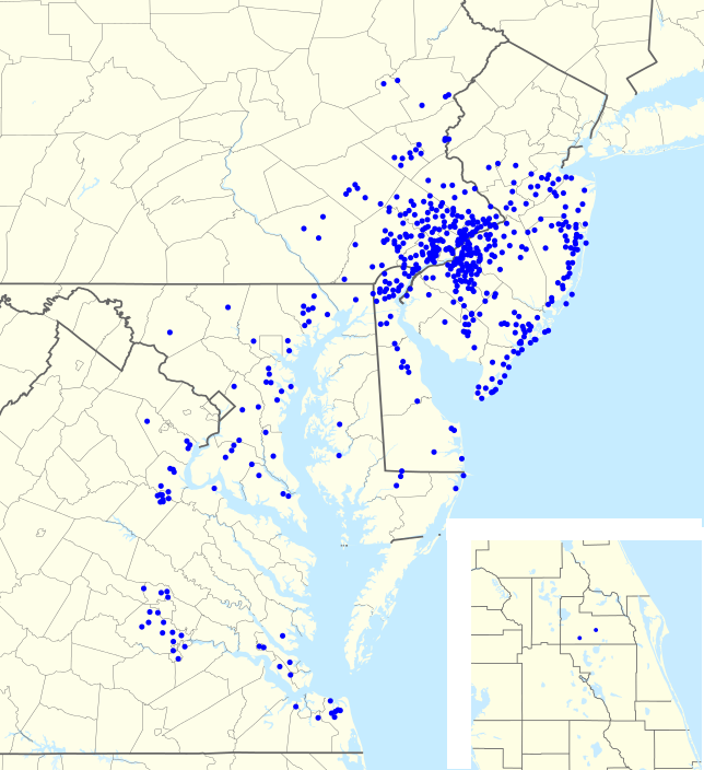
| वर्तमान | 22:57, 31 जुलाई 2012 | | 644 × 704 (138 KB) | Magog the Ogre | == {{int:filedesc}} == {{Information |Description={{en|1=Footprint of en:Wawa Inc. as of {{ISOdate|2011-06-25}}.}} |Source={{Derived from|USA_Pennsylvania_location_map.svg|USA_New_Jersey_location_map.svg|USA_Maryland_location_map.svg|USA_New_York... |
चित्र का उपयोग
इस चित्र से कोई पन्ने नहीं जुड़ते
मेटाडेटा
इस फ़ाइल में अतिरिक्त जानकारी मौजूद है, जो शायद इसे बनाने या डिजिटाइज़ करने के लिए उपयुक्त डिजिटल कैमरा या फिर स्कैनर द्वारा जोड़ा गया हो।
अगर चित्र को इसके मूल रूप से बदला गया है, शायद कुछ जानकारी इसके वर्तमान स्थिति से संबंधित न हो।
| क्षैतिज रेसोल्यूशन | 35.43 dpc |
|---|---|
| वर्टिकल रिज़ोल्यूशन | 35.43 dpc |
| फ़ाइल बदलाव दिनांक और समय | 22:42, 31 जुलाई 2012 |