File:East-Hem_475ad.jpg
ויקיפדיה האנציקלופדיה encyclopedia
לקובץ המקורי (3,240 × 1,903 פיקסלים, גודל הקובץ: 753 ק"ב, סוג MIME: image/jpeg)
| זהו קובץ שמקורו במיזם ויקישיתוף. תיאורו בדף תיאור הקובץ המקורי (בעברית) מוצג למטה. |

|
יש ליצור מחדש את התמונה historical map הזו באמצעות גרפיקה וקטורית כדוגמת קובץ SVG. לפעולה זו מספר יתרונות, כפי שניתן לקרוא (באנגלית) בדף Commons:Media for cleanup. אם ברשותכם קובץ SVG, אנא העלו אותו. לאחר מכן, החליפו תבנית זו בתבנית
{{vector version available|שם הקובץ.svg}} |
 | תמונה זו (או כל התמונות בערך או בקטגוריה זו) הועלתה בפורמט JPEG. ואולם התמונה כוללת מידע שניתן לאחסנו בצורה יעילה יותר או מדויקת יותר בפורמט PNG או SVG. אם ניתן להעלות גרסה בפורמט PNG או SVG של תמונה זו ללא שינויים ברזולוציה, נגזרת ממקור שאינו JPEG או פגיעה באיכות, מומלץ להעלותה בפורמט כזה. |  |
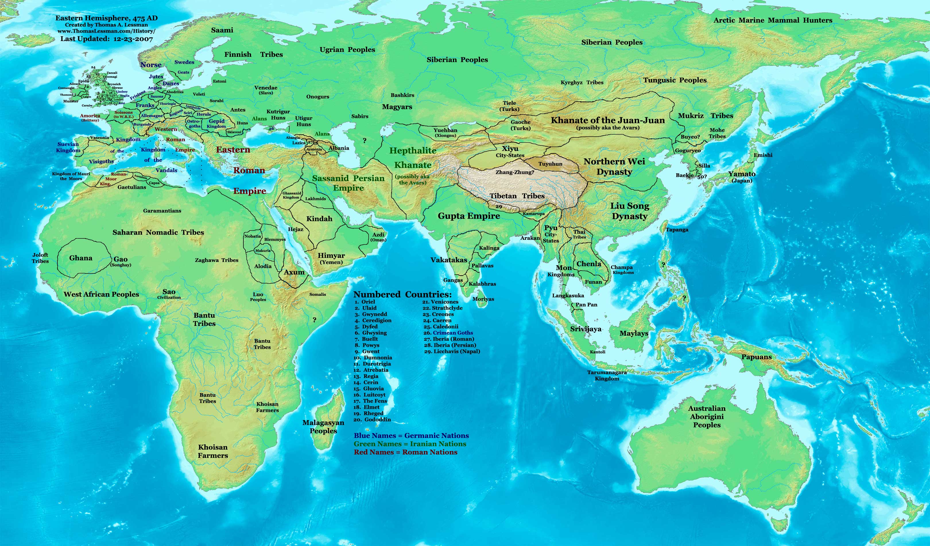
| תיאורEast-Hem 475ad.jpg | Eastern Hemisphere in 475 AD. |
| מקור | self-made (For reference information, see the Map Source References section below.) |
| יוצר | Thomas Lessman (Contact!) |
| אישורים והיתרים (שימוש חוזר בקובץ זה) |
אני, בעל זכויות היוצרים על עבודה זו, מפרסם בזאת את העבודה תחת הרישיון הבא: הקובץ הזה מתפרסם לפי תנאי רישיון קריאייטיב קומונז ייחוס-שיתוף זהה 3.0 לא מותאם.
|
| גרסאות אחרות |
see the East-Hem 475ad.jpg File History section below.
Map SummaryOriginal Source URL: http://www.thomaslessman.com/History/images/East-Hem_475ad.jpg. This map of the Eastern Hemisphere in 475 AD was created by Thomas Lessman, based on information from the sources listed below. This map is free for educational use (see Permission info above). When using this map, please mention that it is available for free at www.WorldHistoryMaps.info.
Map Source References
References for information contained in this map: 1. Borders of Europe are mostly derived from the Euratlas.com map of Europe in 500 AD. 2. Borders of Britain are derived from the "EarlyBritishKingdoms.com", map of map Britain in 475 AD. 3. Borders of Asian countries derive from various Wikipedia articles and Google history map searches. 4. Some information is derived from Wikimedia's map of The world in 500 CE, created by User:Javierfv1212. 5. Much of the information in this map was cross-checked with Bruce Gordon's Regnal Chronologies. |
Other Historical Maps by Thomas Lessman
| Maps of the eastern hemisphere showing history
Bold dates are available on Wikimedia or Wikipedia. | ||
| Primeval | ||
| Ancient
|
·| 600 BC | 550 BC | 527 BC | 500 BC |
400 BC | ·| 1 AD | 50 AD | 100 AD | 200 AD | 300 AD | | |
| Medieval |
·| 500 AD | 565 AD | 600 AD | 700 AD | | |
| Modern |
·| 1500 AD | · * For historical maps of the whole world, | |
| history links talk edit view | ||
כיתובים
פריטים שמוצגים בקובץ הזה
מוצג
ערך כלשהו ללא פריט ויקינתונים
image/jpeg
היסטוריית הקובץ
ניתן ללחוץ על תאריך/שעה כדי לראות את הקובץ כפי שנראה באותו זמן.
| תאריך/שעה | תמונה ממוזערת | ממדים | משתמש | הערה | |
|---|---|---|---|---|---|
| נוכחית | 18:17, 7 בפברואר 2008 | | 1,903 × 3,240 (753 ק"ב) | Rottweiler | {{Information |Description= == Summary == Author: Thomas A. Lessman. Source URL: http://www.ThomasLessman.com/History/images/East-Hem_475ad.jpg. Image was created by Thomas Lessman based on historical information located in sources listed below. This map |
שימוש בקובץ
![]() אין בוויקיפדיה דפים המשתמשים בקובץ זה.
אין בוויקיפדיה דפים המשתמשים בקובץ זה.
שימוש גלובלי בקובץ
אתרי הוויקי השונים הבאים משתמשים בקובץ זה:
- שימוש באתר ar.wikipedia.org
- שימוש באתר ce.wikipedia.org
- שימוש באתר de.wikipedia.org
- שימוש באתר el.wikipedia.org
- שימוש באתר en.wikipedia.org
- שימוש באתר es.wikipedia.org
- שימוש באתר fr.wikipedia.org
- שימוש באתר rue.wikipedia.org
- שימוש באתר ru.wikipedia.org
- שימוש באתר sh.wikipedia.org
- שימוש באתר sv.wikipedia.org
- שימוש באתר ta.wikipedia.org
מטא־נתונים
קובץ זה מכיל מידע נוסף, שכנראה הגיע ממצלמה דיגיטלית או מסורק שבהם הקובץ נוצר או עבר דיגיטציה.
אם הקובץ שונה ממצבו הראשוני, כמה מהנתונים להלן עלולים שלא לשקף באופן מלא את הקובץ הנוכחי.
| _error | 0 |
|---|