File:Colonisation_1885.png
ויקיפדיה האנציקלופדיה encyclopedia
לקובץ המקורי (1,200 × 526 פיקסלים, גודל הקובץ: 206 ק"ב, סוג MIME: image/png)
| זהו קובץ שמקורו במיזם ויקישיתוף. תיאורו בדף תיאור הקובץ המקורי (בעברית) מוצג למטה. |
| References for this description (or part of this) or for the depiction in the file are not provided. |
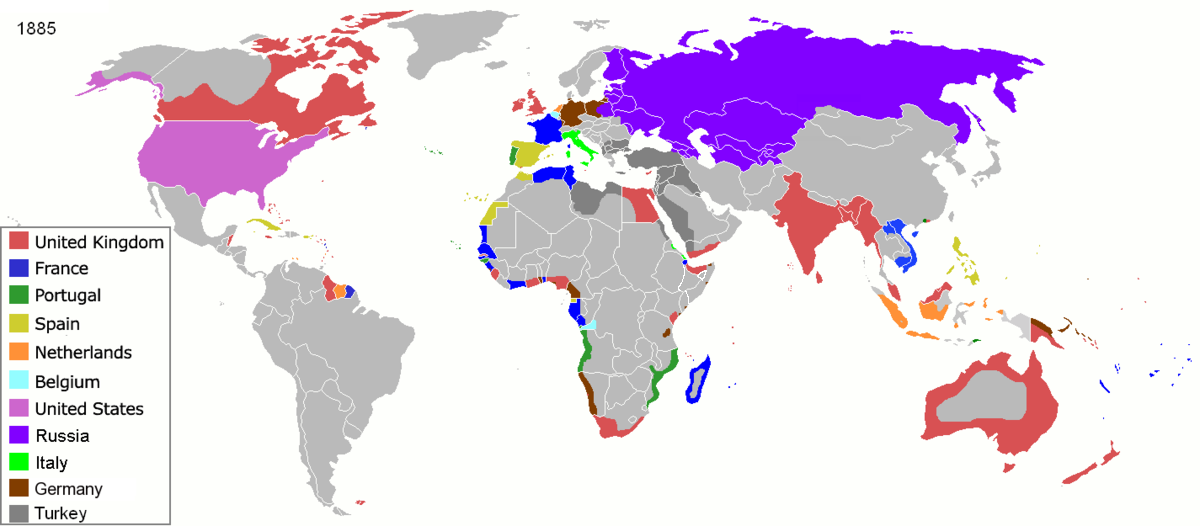
| תיאורColonisation 1885.png |
Map of major world powers by year, derived from public domain animated map on wikipedia.
As the orriginal licence of the animation was Public Domain, this image which has been derived from it is too:
|
|||||||||||||||||||
| תאריך יצירה | ||||||||||||||||||||
| מקור | public domain animated map by ArdadN here | |||||||||||||||||||
| יוצר | ArdadN | |||||||||||||||||||
.jpg)
._LOC_2001620596.jpg)

|
יש ליצור מחדש את התמונה historical map הזו באמצעות גרפיקה וקטורית כדוגמת קובץ SVG. לפעולה זו מספר יתרונות, כפי שניתן לקרוא (באנגלית) בדף Commons:Media for cleanup. אם ברשותכם קובץ SVG, אנא העלו אותו. לאחר מכן, החליפו תבנית זו בתבנית
{{vector version available|שם הקובץ.svg}} |
כיתובים
22 במרץ 2007
image/png
210,626 בית
526 פיקסל
1,200 פיקסל
היסטוריית הקובץ
ניתן ללחוץ על תאריך/שעה כדי לראות את הקובץ כפי שנראה באותו זמן.
| תאריך/שעה | תמונה ממוזערת | ממדים | משתמש | הערה | |
|---|---|---|---|---|---|
| נוכחית | 12:05, 8 בנובמבר 2021 | | 526 × 1,200 (206 ק"ב) | Randomastwritter | jubaland |
| 12:52, 5 באפריל 2020 |  | 526 × 1,200 (206 ק"ב) | Ориенталист | South Sakhalin was part of Russia in 1885 | |
| 14:17, 2 במאי 2015 |  | 625 × 1,425 (49 ק"ב) | Chrischerf | German Empire and colonies in 1885; Sudan under control of the Mahdi | |
| 05:57, 3 באוגוסט 2014 |  | 625 × 1,425 (54 ק"ב) | Alvin Lee | correcting the boundaries of Russia and China | |
| 16:54, 3 בנובמבר 2013 |  | 625 × 1,425 (78 ק"ב) | McZusatz | Reverted to version as of 00:22, 24 January 2011 [corrupt file?] | |
| 18:24, 3 בנובמבר 2012 |  | 625 × 1,425 (67 ק"ב) | Franco310397 | Spanish presence in Micronesia (Oceania) included in the Captaincy General of the Philippines. In the Caroline Islands and the Mariana Islands. | |
| 03:22, 24 בינואר 2011 |  | 625 × 1,425 (78 ק"ב) | Micsha~commonswiki | Reverted to version as of 02:17, 3 May 2010 | |
| 03:22, 24 בינואר 2011 |  | 326 × 506 (85 ק"ב) | Micsha~commonswiki | Only Africa; includes map key | |
| 05:17, 3 במאי 2010 |  | 625 × 1,425 (78 ק"ב) | Kieran4 | slight edit | |
| 05:14, 3 במאי 2010 |  | 625 × 1,425 (78 ק"ב) | Kieran4 | Correct Dutch East INdies |
שימוש בקובץ
הדף הבא משתמש בקובץ הזה:
שימוש גלובלי בקובץ
אתרי הוויקי השונים הבאים משתמשים בקובץ זה:
- שימוש באתר am.wikipedia.org
- שימוש באתר de.wikipedia.org
- שימוש באתר en.wikipedia.org
- שימוש באתר es.wikipedia.org
- שימוש באתר fr.wikipedia.org
- שימוש באתר oc.wikipedia.org
- שימוש באתר sk.wikipedia.org
מטא־נתונים
קובץ זה מכיל מידע נוסף, שכנראה הגיע ממצלמה דיגיטלית או מסורק שבהם הקובץ נוצר או עבר דיגיטציה.
אם הקובץ שונה ממצבו הראשוני, כמה מהנתונים להלן עלולים שלא לשקף באופן מלא את הקובץ הנוכחי.
| הערה בקובץ PNG | |
|---|---|
| רזולוציה אופקית | 47.24 dpc |
| רזולוציה אנכית | 47.24 dpc |
| תוכנה בשימוש |
|