File:Han_foreign_relations_CE_2_chinese.jpg
From Wikipedia, the free encyclopedia
Hoton asali (pikisal 965 × 650, girman fayil: 530 KB, irin MIME: image/jpeg)
Wannan hoto yazo daga Wikimedia Commons kuma za'a iya amfani dashi a wasu projects. Anan kasa an nuna asalin bayanin shi
- Chinese language version of "Map of Han foreign relations in CE 2"
Kanun bayannai
Introduction
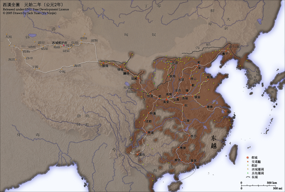
This map shows the world as was known to Han Dynasty China in CE 2. Names of non-Chinese peoples and states have been purposely left with their Chinese names (e.g. Dayuan instead of Fergana; Gaogouli instead of Goguryeo) to reflect the fact that our knowledge of participants in the Han world order comes almost exclusively from Chinese sources.
- Credits
- Chinese Version of Image:Han foreign relations CE 2.jpg.
- Created and copyright (2005) by Yu Ninjie.
- Released under the GNU FDL.
Territorial garrisons
The headquarters of chief commandants (都尉) are shown in yellow. Chief commandants commanded territorial garrisons and were responsible for the supression of local armed threats and supervision of recruitment for military service. Note that these were concentrated on the frontiers, especially on the northern border region. When in the interior of the Han empire, they were often placed near iron or salt industries, or on important communication routes. A few dependent states (屬國) are shown in green. These were usually mixed settlements of Chinese and Xiongnu or more commonly, Qiang, under Han administration.
The Great Wall
During most of the Western Han period, the Great Wall served as a line of demarcation between Han and non-Chinese peoples, most notable of whom were the Xiongnu. The line of the Great Wall was extended by Emperor Wu along the Gansu corridor (the commanderies based at Dunhuang, Lufu, Lude and Guzang). This, along with walls north of the great loop of the Yellow River (beyond Wuyuan), provided the front line defences against the Xiongnu. A second line was maintained along the old Qin wall (the one that passes close to Fushi and Didao), which was important even into the 1st century CE.
Both the lines of the Great Wall and Yellow River are based on Tan Qixiang (ed.), Zhongguo lishi ditu (中国历史地图集), 1982. Note that the Yellow River is considerably to the north of its present flow.
Routes of communication
The broad outline of communication and transport routes from the capital Chang'an is marked in white. These were based on Qin Dynasty imperial highways, Han roads (such as the Chang'an-Anyi-Taiyuan-Yu road) and navigable riverways (such as the Chenliu and Shouchun river routes). The long road, often known as the Silk Road, extended west from Chang'an to the "Western Regions".
These are based in part on the reconstruction of early Chinese roads and waterways by Joseph Needham in Science and Civilisation, Vol. IV, 1954-, and the additions of Rafe de Crespigny in Generals of the South, 1992. The northern and southern routes of the Silk Road in the Western Regions is based on Map 16 in Cambridge History of China, vol. 1, 1986.
The Western Regions
From the end of the 2nd century CE, Han China fought with the Xiongnu over control of the "Western Regions". By the time that they established the office of Protector General of the Western Regions (at Wulei) in 60 BCE or 59 BCE, the entire region was dominated by the Chinese. Tributary city-states, in light orange, sent periodic tribute to Chang'an and were rewarded by the Han court.
License and Source

|
An bada damar a kofa, a yaɗa/ko sauya wannan kundi ƙarƙashin Lasisin GNU ta kyauta, Fitarwa na 1.2 ko duk wani fitarwa da zai biyo baya daga Gidauniyar Samar da Software ta Kyauta; ba tare da sauyin sashe ba, babu Rubutun Fuskar gaban shafi, kuma babu Rubutun bayan shafi. Kofi na lasisin na nan an sanya sa aciki ƙarƙashin sashen GNU Free Documentation License.http://www.gnu.org/copyleft/fdl.htmlGFDLGNU Free Documentation Licensetruetrue |
| Wannan fayil ɗin an bada lasisin shi ƙarƙashin Creative Commons Attribution-Share Alike 3.0 Unported lasisi. | ||
| ||
| This licensing tag was added to this file as part of the GFDL licensing update.http://creativecommons.org/licenses/by-sa/3.0/CC BY-SA 3.0Creative Commons Attribution-Share Alike 3.0truetrue |
- Source
- Chinese Wikipedia, original upload 2005年4月7日 (木) by Yu Ninjie
Take
Abubuwan da aka nuna a cikin wannan fayil
depicts Turanci
copyright status Turanci
copyrighted Turanci
Tarihin fayil
Ku latsa rana/lokaci ku ga fayil yadda yake a wannan lokaci
| Rana/Lokaci | Wadar sufa | Kusurwowi | Ma'aikaci | Bahasi | |
|---|---|---|---|---|---|
| na yanzu | 03:37, 25 ga Yuni, 2009 | | 965 × 650 (530 KB) | KEIMS | add a name |
| 09:29, 13 Disamba 2005 |  | 965 × 650 (516 KB) | Shizhao | ||
| 02:51, 4 Oktoba 2005 |  | 965 × 650 (558 KB) | Saperaud~commonswiki | Chinese Version of Image:Han foreign relations CE 2.jpg. Created and copyright (2005) by Yu Ninjie. Released under the GNU FDL. This map shows the world as was known to Han Dynasty China |
Amfani da fayil
Babu shafuka da suke amfani da fayil din nan.
Amfanin fayil a ko'ina
Wadannan sauran wikis suna amfani da fayil din anan
- Amfani a kan av.wikipedia.org
- Amfani a kan azb.wikipedia.org
- Amfani a kan incubator.wikimedia.org
- Amfani a kan ja.wikipedia.org
- Amfani a kan rue.wikipedia.org
- Amfani a kan ru.wikipedia.org
- Amfani a kan th.wikipedia.org
- Amfani a kan wikimania2006.wikimedia.org
- Amfani a kan yi.wikipedia.org
- Amfani a kan zh-classical.wikipedia.org
- Amfani a kan zh-min-nan.wikipedia.org
- Amfani a kan zh.wikipedia.org
bayannan meta
Wannan fayil ya ƙumshi ƙarin bayani daga kyamarar dijita ko sikanan da aka yi amfani da su.
Idan an sauya fayil kin, to wasu bayannan na ainahi ba za su fito ba sosai a cikin sabon fayil kin.
| Orientation | Normal |
|---|---|
| Horizontal resolution | 150 dpi |
| Vertical resolution | 150 dpi |
| Software used | Adobe Photoshop CS2 Windows |
| File change date and time | 23:36, 24 ga Yuni, 2009 |
| Color space | sRGB |
| Image width | 965 px |
| Image height | 650 px |
| Date and time of digitizing | 22:58, 7 ga Afirilu, 2005 |
| Date metadata was last modified | 19:36, 24 ga Yuni, 2009 |
| IIM version | 2 |