ચિત્ર:Ancient_Egypt_map-en.svg
From Wikipedia, the free encyclopedia

મૂળભુત ફાઇલ (SVG ફાઇલ, માત્ર ૧,૫૭૭ × ૩,૨૧૯ પીક્સલ, ફાઇલનું કદ: ૬૮૭ KB)
આ ફાઇલ Wikimedia Commonsનો ભાગ છે અને શક્ય છે કે અન્ય પ્રકલ્પોમાં પણ વપરાઇ હોય. ત્યાંનાં મૂળ ફાઇલનાં વર્ણનનાં પાના પર આપેલું વર્ણન નીચે દર્શાવેલું છે.
|
સારાંશ:
| વર્ણનAncient Egypt map-en.svg |
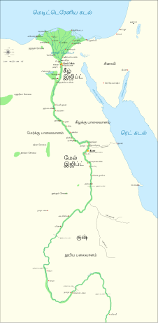
Català: Mapa de l'antic Egipte, que mostra el Nil fins a la cinquena cataracta, i les principals ciutats i llocs del període dinàstic (c. 3150 aC a 30 aC). El Caire i Jerusalem es mostren com a ciutats de referència.
English: Map of Ancient Egypt, showing the Nile up to the fifth cataract, and major cities and sites of the Dynastic period (c. 3150 BC to 30 BC). Cairo and Jerusalem are shown as reference cities. |
| તારીખ | |
| સ્રોત |
Own work using:
Coordinates:
|
| લેખક | Jeff Dahl |
| અન્ય આવૃત્તિઓ |
File:Ancient Egypt map-en.svg has 5 translations.
Other related versions:[ફેરફાર કરો]
|


| This SVG file contains embedded text that can be translated into your language, using any capable SVG editor, text editor or the SVG Translate tool. For more information see: About translating SVG files. |
This file is translated using SVG <switch> elements. All translations are stored in the same file! Learn more.
For most Wikipedia projects, you can embed the file normally (without a To translate the text into your language, you can use the SVG Translate tool. Alternatively, you can download the file to your computer, add your translations using whatever software you're familiar with, and re-upload it with the same name. You will find help in Graphics Lab if you're not sure how to do this. |
પરવાના

|
આ રચનાની નકલ કરવા, વિતરણ અને સુધારો કરવા માટે GNU Free Documentation License, આવૃત્તિ 1.2 કે અન્ય આગળની આવૃત્તિ Free Software Foundation હેઠળ પરવાનગી છે; જેમાં કોઈ Invariant Sections, no Front-Cover Texts, and no Back-Cover Texts નથી. આ પરવાનાની પ્રત GNU Free Documentation License વિભાગમાં છે.http://www.gnu.org/copyleft/fdl.htmlGFDLGNU Free Documentation Licensetruetrue |
- તમે મુક્ત છો:
- વહેંચવા – નકલ કરવા, વિતરણ કરવા અને રચનાઓ મોકલવા
- રીમિક્સ કરવા કે મઠારવા – રચના અપનાવવા
- નીચેની શરત હેઠળ:
- આરોપણ – તમારે આ રચનાનો ઉપયોગ કરવા માટે લેખક કે પ્રકાશન અધિકાર ધારકની યોગ્ય માહિતી, પરવાનગી (લાયસન્સ)ની કડી અને તેમાં ફેરફાર કર્યો હોય તો તેનો ઉલ્લેખ કરવો જ પડશે. તમે આ સત્તા અનુસાર જ આ રચનાનો પ્રયોગ થવો જોઈએ, પણ તેઓ તમને અથવા તમારા ઉપયોગ સાથે સંમત થાય છે તે રીતે નહીં.
- શેર- અલાઈક (બિન ભેદભાવ વહેંચણી) – તમે જો આ રચનાને બદલશો, તેમાં ફેરફાર કરશો અથવા તેના પર આધારિત કોઇ કાર્ય બનાવશો તો તમારે પરિણામી કાર્યને તે જ અથવા અનુરૂપ પરવાનગી હેઠળ જ પ્રકાશિત કરવું પડશે.
અસલ - મૂળ અપલોડનો લોગ
The original description page is/was here. All following user names refer to Commons.
- 2009-01-29 13:21 Bibi Saint-Pol 1577×3219×0 (412000 bytes) (remove wrong text, adjust frame)
- 2009-01-29 12:47 Bibi Saint-Pol 1577×3219×0 (413000 bytes) (added frame)
- 2009-01-29 12:35 Bibi Saint-Pol 1577×3219×0 (412000 bytes) (harmonize colors with the standards + replace unsupported Arial fonts by DejaVu )
- 2008-02-11 06:55 Jeff Dahl 1577×3219×0 (391000 bytes) (sp fx)
- 2007-11-29 02:09 Jeff Dahl 1577×3219×0 (391000 bytes) (Rotate Mediterranean Sea label)
- 2007-11-27 23:32 Jeff Dahl 1577×3219×0 (391000 bytes) (Minor adjustments to Naukratis and Buto)
- 2007-11-27 18:59 Jeff Dahl 1577×3219×0 (391000 bytes) (Cairo and Jerusalem now with black dots/italics)
- 2007-11-23 00:04 Jeff Dahl 1577×3219×0 (391000 bytes) (fx scalebar)
- 2007-11-22 23:56 Jeff Dahl 1577×3219×0 (391000 bytes) ({{Information |Description=A map of ancient Egypt, made with Inkscape |Source=self-made |Date=11-22-07 |Author= Jeff Dahl |Permission= |other_versions={{DerivativeVersions|Ancient Egypt map-ru.svg}} }} )
Captions
Items portrayed in this file
દર્શાવે છે
some value
copyrighted અંગ્રેજી
૨૨ નવેમ્બર 2007
media type અંગ્રેજી
image/svg+xml
checksum અંગ્રેજી
955c156a96b2d10b85ced835ac6c60ee2253122d
data size અંગ્રેજી
૬,૪૧,૨૬૬ byte
૩,૨૧૯ pixel
width અંગ્રેજી
૧,૫૭૭ pixel
ફાઇલનો ઇતિહાસ
તારીખ/સમય ઉપર ક્લિક કરવાથી તે સમયે ફાઇલ કેવી હતી તે જોવા મળશે.
| તારીખ/સમય | લઘુચિત્ર | પરિમાણો | સભ્ય | ટિપ્પણી | |
|---|---|---|---|---|---|
| વર્તમાન | ૦૯:૦૯, ૨૦ ઓક્ટોબર ૨૦૨૩ | | ૧,૫૭૭ × ૩,૨૧૯ (૬૮૭ KB) | Haziq Faruqi | File uploaded using svgtranslate tool (https://svgtranslate.toolforge.org/). Added translation for ms. |
| ૦૫:૨૬, ૧૮ માર્ચ ૨૦૨૨ |  | ૧,૫૭૭ × ૩,૨૧૯ (૬૨૬ KB) | Manlleus | File uploaded using svgtranslate tool (https://svgtranslate.toolforge.org/). Added translation for ca. | |
| ૨૦:૫૩, ૬ માર્ચ ૨૦૨૨ |  | ૧,૫૭૭ × ૩,૨૧૯ (૫૬૪ KB) | Scratchinghead | File uploaded using svgtranslate tool (https://svgtranslate.toolforge.org/). Added translation for ta. | |
| ૧૧:૩૩, ૨૫ ફેબ્રુઆરી ૨૦૨૨ |  | ૧,૫૭૭ × ૩,૨૧૯ (૫૬૪ KB) | Scratchinghead | File uploaded using svgtranslate tool (https://svgtranslate.toolforge.org/). Added translation for ta. | |
| ૦૦:૫૯, ૭ માર્ચ ૨૦૨૦ |  | ૧,૫૭૭ × ૩,૨૧૯ (૫૦૧ KB) | Nilesh shukla | File uploaded using svgtranslate tool (https://tools.wmflabs.org/svgtranslate/). Added translation for hi. | |
| ૧૬:૫૮, ૨૦ ફેબ્રુઆરી ૨૦૦૯ |  | ૧,૫૭૭ × ૩,૨૧૯ (૪૧૩ KB) | Bibi Saint-Pol | fix translation mistake on the windrose | |
| ૧૭:૪૩, ૩૦ જાન્યુઆરી ૨૦૦૯ |  | ૧,૫૭૭ × ૩,૨૧૯ (૪૧૩ KB) | Bibi Saint-Pol | fix position of Nile Delta | |
| ૧૭:૫૧, ૨૯ જાન્યુઆરી ૨૦૦૯ |  | ૧,૫૭૭ × ૩,૨૧૯ (૪૧૨ KB) | Bibi Saint-Pol | remove wrong text, adjust frame | |
| ૧૭:૩૫, ૨૯ જાન્યુઆરી ૨૦૦૯ |  | ૧,૫૭૭ × ૩,૨૧૯ (૪૧૩ KB) | Bibi Saint-Pol | {{Assessments|1=Ancient Egypt map.svg|enwiki=1}} __NOTOC__ == {{int:filedesc}} == {{inkscape}} {{Information |Description= {{en|Map of Ancient Egypt, showing the Nile up to the fifth cataract, and major cities and sites of the Dynastic period (c. 3150 BC |
ફાઇલનો વપરાશ
આ ફાઇલ માં નીચેનું પાનું વપરાયેલું છે:
ફાઇલનો વ્યાપક ઉપયોગ
નીચેની બીજી વિકિઓ આ ફાઈલ વાપરે છે:
- anp.wikipedia.org પર વપરાશ
- azb.wikipedia.org પર વપરાશ
- blk.wikipedia.org પર વપરાશ
- bn.wikipedia.org પર વપરાશ
- bs.wikipedia.org પર વપરાશ
- ca.wikipedia.org પર વપરાશ
- ceb.wikipedia.org પર વપરાશ
- ckb.wikipedia.org પર વપરાશ
- cs.wikipedia.org પર વપરાશ
- cv.wikipedia.org પર વપરાશ
- da.wikipedia.org પર વપરાશ
- en.wikipedia.org પર વપરાશ
- Ancient Egypt
- History of Africa
- Jean-François Champollion
- Old Kingdom of Egypt
- First Intermediate Period of Egypt
- 671 BC
- Wikipedia:WikiProject Former countries
- Cradle of civilization
- Portal:Africa
- Portal:Africa/Featured article
- Portal:Africa/Featured picture
- Portal:Ancient Egypt
- Portal:Ancient Egypt/Selected picture
- Portal talk:Africa/Featured picture
- Africa
- Portal:Maps/Selected picture
- Thinite Confederacy
- Portal:Africa/Featured article/2
- Wikipedia:Featured pictures thumbs/09
- Wikipedia:Picture peer review/Ancient Egypt main map
- Wikipedia:Featured picture candidates/November-2007
- Wikipedia:Featured picture candidates/Ancient Egypt map-en.svg
- Wikipedia:Wikipedia Signpost/2007-12-03/Features and admins
- Portal:Africa/Featured picture/22
- Portal:Maps/Selected picture/32
- User talk:Jeff Dahl/Archive 2
- Portal:Ancient Egypt/Selected picture/2
- User talk:Jeff Dahl/Archive 3
આ ફાઇલના વધુ વૈશ્વિક વપરાશ જુઓ.
મૅટાડેટા
આ માધ્યમ સાથે વધુ માહિતી સંકળાયેલી છે, જે સંભવતઃ માધ્યમ (ફાઇલ) બનાવવા માટે ઉપયોગમાં લેવાયેલા ડિજીટલ કેમેરા કે સ્કેનર દ્વારા ઉમેરવામાં આવી હશે.
જો માધ્યમને તેના મૂળરૂપમાંથી ફેરફાર કરવામાં આવશે તો શક્ય છે કે અમુક માહિતી પૂરેપૂરી હાલમાં છે તેવી રીતે ન જળવાઈ રહે.
| પહોળાઈ | 1577.348 |
|---|---|
| ઊંચાઈ | 3219.4182 |