File:Ancient_Egypt_main_map.png
From Wikipedia, the free encyclopedia
આ પૂર્વાવલોકનનું કદ: ૨૯૩ × ૫૯૮ પિક્સેલ. અન્ય આવર્તનો: ૧૧૭ × ૨૪૦ પિક્સેલ | ૨૩૫ × ૪૮૦ પિક્સેલ | ૩૭૬ × ૭૬૮ પિક્સેલ | ૫૦૧ × ૧,૦૨૪ પિક્સેલ | ૧,૫૭૭ × ૩,૨૧૯ પિક્સેલ.
મૂળભુત ફાઇલ (૧,૫૭૭ × ૩,૨૧૯ પીક્સલ, ફાઇલનું કદ: ૫૫૫ KB, MIME પ્રકાર: image/png)
આ ફાઇલ Wikimedia Commonsનો ભાગ છે અને શક્ય છે કે અન્ય પ્રકલ્પોમાં પણ વપરાઇ હોય. ત્યાંનાં મૂળ ફાઇલનાં વર્ણનનાં પાના પર આપેલું વર્ણન નીચે દર્શાવેલું છે.

|
File:Ancient Egypt map-en.svg is a vector version of this file. It should be used in place of this PNG file.
File:Ancient Egypt main map.png → File:Ancient Egypt map-en.svg
For more information, see Help:SVG.
|
 |
સારાંશ:
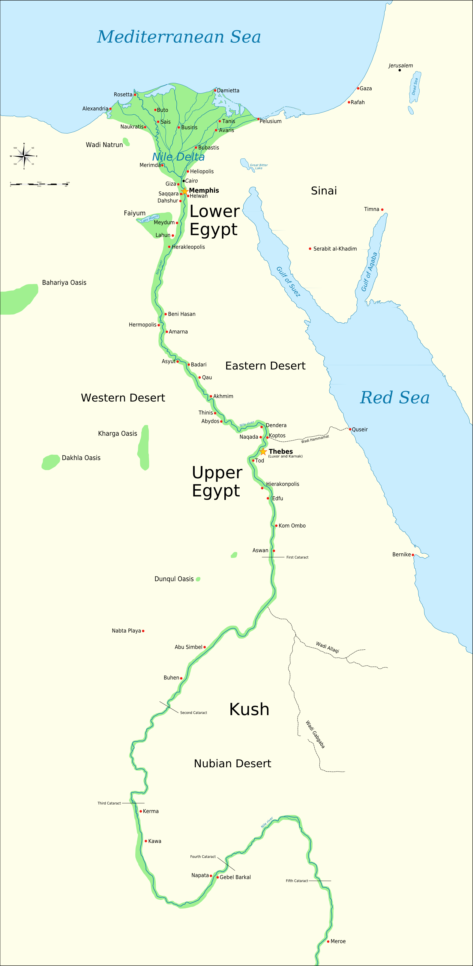
| વર્ણનAncient Egypt main map.png | A map of ancient Egypt, showing the Sinai, and the nile up to nearly the 5th cataract. The map is annotated with most of the important ancient Egyptian cities. Both Memphis and Thebes are marked as capitals. The colors chosen are based on the standard palette of colors suggested on the maps portal. |
| તારીખ | |
| સ્રોત | પોતાની રચના. This work was done in photoshop, and I can make many other specialized maps based on this template with different overlays, showing mining regions, territorial control etc. Just ask! Need a translated version? Just tell me the names of as many places you can in your language and I can make one for you. |
| લેખક | Jeff Dahl |
પરવાના
હું, આ કાર્યનો પ્રકાશનાધિકાર ધારક, તેને નીચેના પરવાનાઓ હેઠળ અહીં પ્રકાશીત કરૂં છું:

|
આ રચનાની નકલ કરવા, વિતરણ અને સુધારો કરવા માટે GNU Free Documentation License, આવૃત્તિ 1.2 કે અન્ય આગળની આવૃત્તિ Free Software Foundation હેઠળ પરવાનગી છે; જેમાં કોઈ Invariant Sections, no Front-Cover Texts, and no Back-Cover Texts નથી. આ પરવાનાની પ્રત GNU Free Documentation License વિભાગમાં છે.http://www.gnu.org/copyleft/fdl.htmlGFDLGNU Free Documentation Licensetruetrue |
આ ફાઈલ વપરાશની પરવાનગી : Creative Commons Attribution-Share Alike 3.0 Unported, 2.5 Generic, 2.0 Generic and 1.0 Generic license.
- તમે મુક્ત છો:
- વહેંચવા – નકલ કરવા, વિતરણ કરવા અને રચનાઓ મોકલવા
- રીમિક્સ કરવા કે મઠારવા – રચના અપનાવવા
- નીચેની શરત હેઠળ:
- આરોપણ – તમારે આ રચનાનો ઉપયોગ કરવા માટે લેખક કે પ્રકાશન અધિકાર ધારકની યોગ્ય માહિતી, પરવાનગી (લાયસન્સ)ની કડી અને તેમાં ફેરફાર કર્યો હોય તો તેનો ઉલ્લેખ કરવો જ પડશે. તમે આ સત્તા અનુસાર જ આ રચનાનો પ્રયોગ થવો જોઈએ, પણ તેઓ તમને અથવા તમારા ઉપયોગ સાથે સંમત થાય છે તે રીતે નહીં.
- શેર- અલાઈક (બિન ભેદભાવ વહેંચણી) – તમે જો આ રચનાને બદલશો, તેમાં ફેરફાર કરશો અથવા તેના પર આધારિત કોઇ કાર્ય બનાવશો તો તમારે પરિણામી કાર્યને તે જ અથવા અનુરૂપ પરવાનગી હેઠળ જ પ્રકાશિત કરવું પડશે.
તમે તમારી પસંદગીનો પરવાનો પસંદ કરી શકો છો.
eo:dosiero:Mapo de antikva Egiptio.jpg
Captions
Add a one-line explanation of what this file represents
Items portrayed in this file
દર્શાવે છે
some value
copyrighted અંગ્રેજી
૧૮ સપ્ટેમ્બર 2007
source of file અંગ્રેજી
original creation by uploader અંગ્રેજી
media type અંગ્રેજી
image/png
checksum અંગ્રેજી
19b156b229535c9a5b5350b221d2f7536eedbf84
data size અંગ્રેજી
૫,૬૮,૦૮૯ byte
૩,૨૧૯ pixel
width અંગ્રેજી
૧,૫૭૭ pixel
ફાઇલનો ઇતિહાસ
તારીખ/સમય ઉપર ક્લિક કરવાથી તે સમયે ફાઇલ કેવી હતી તે જોવા મળશે.
| તારીખ/સમય | લઘુચિત્ર | પરિમાણો | સભ્ય | ટિપ્પણી | |
|---|---|---|---|---|---|
| વર્તમાન | ૧૬:૫૯, ૨૦ ફેબ્રુઆરી ૨૦૦૯ | | ૧,૫૭૭ × ૩,૨૧૯ (૫૫૫ KB) | Bibi Saint-Pol | fix translation mistake on the rosewind |
| ૧૭:૫૨, ૨ ફેબ્રુઆરી ૨૦૦૯ |  | ૨,૦૦૦ × ૪,૦૮૨ (૭૪૪ KB) | Bibi Saint-Pol | Correction problème de police | |
| ૧૭:૪૪, ૨ ફેબ્રુઆરી ૨૦૦૯ |  | ૨,૦૦૦ × ૪,૦૮૨ (૭૪૪ KB) | Bibi Saint-Pol | correction export précédent | |
| ૧૭:૪૨, ૨ ફેબ્રુઆરી ૨૦૦૯ |  | ૨,૦૦૦ × ૪,૫૭૧ (૬૫૭ KB) | Bibi Saint-Pol | correction de bavures d'export dues à Inkscape | |
| ૧૭:૫૦, ૨૯ જાન્યુઆરી ૨૦૦૯ |  | ૧,૫૭૭ × ૩,૨૧૯ (૫૫૫ KB) | Bibi Saint-Pol | new version based on the SVG (more up to date) | |
| ૨૩:૪૨, ૧ ઓક્ટોબર ૨૦૦૭ | ૧,૨૩૯ × ૩,૦૭૬ (૪૧૭ KB) | Jeff Dahl | adding scalebar | ||
| ૦૦:૫૧, ૨૧ સપ્ટેમ્બર ૨૦૦૭ | ૧,૨૩૯ × ૩,૦૭૬ (૪૧૬ KB) | Jeff Dahl | Adding more cities, done in photoshop. | ||
| ૦૫:૦૮, ૨૦ સપ્ટેમ્બર ૨૦૦૭ | ૧,૨૩૯ × ૩,૦૭૬ (૩૭૭ KB) | Jeff Dahl | adding the rivulets in lower Egypt, self made in photoshop | ||
| ૨૧:૨૮, ૧૯ સપ્ટેમ્બર ૨૦૦૭ | ૧,૨૩૯ × ૩,૦૭૬ (૩૫૮ KB) | Jeff Dahl | Adding two oases | ||
| ૦૯:૫૧, ૧૯ સપ્ટેમ્બર ૨૦૦૭ | ૧,૨૩૯ × ૩,૦૭૬ (૩૪૭ KB) | Jeff Dahl | {{Information |Description=This is a .png map of ancient Egypt, showing the Sinai, and the nile up to nearly the 5th cataract. The map is annotated with most of the important ancient Egyptian cities. Both Memphis and Thebes are marked as capitals. The col |
ફાઇલનો વપરાશ
આ ફાઇલને કોઇ પાનાં વાપરતા નથી.
ફાઇલનો વ્યાપક ઉપયોગ
નીચેની બીજી વિકિઓ આ ફાઈલ વાપરે છે:
- en.wikipedia.org પર વપરાશ