File:Gps-atmosphericefects.xcf
From Wikipedia, the free encyclopedia

Am faidhle tùsail (849 × 837 pixel, meud an fhaidhle: 539 KB, seòrsa MIME: image/x-xcf)
'S ann à Wikimedia Commons a tha am faidhle seo agus faodaidh gu bheil pròiseactan eile 'ga chleachdadh. Chì thu an tuairisgeul a tha aice air [duilleag tuairisgeul an fhaidhle https://commons.wikimedia.org/wiki/File:Gps-atmosphericefects.xcf] gu h-ìosal.
|
|
| TuairisgeulGps-atmosphericefects.xcf |
Español: Efecto de la atmósfera en la propagación de la señal GPS.
English: Effect of the atmosphere in the GPS signal propagation. |
| Ceann-là | (UTC) |
| Tùs | |
| Ùghdar |
|
| Other versions |
| This is a retouched picture, which means that it has been digitally altered from its original version. Modifications: Collage. The original can be viewed here: GPS tracking satellites.jpg:
|
- Faodaidh tu:
- a cho-roinneadh – lethbhreac a dhèanamh dhen obair, a sgaoileadh is a tar-chur
- ath-mheasgachadh – an obair atharrachadh
- Fo bhuaidh nan cumhaichean a leanas:
- urram – Feumaidh tu iomradh a thoirt air an ùghdar no an neach aig a bheil cead air, dìreach mar a thoill iad (ach chan ann air dòigh a chuireas an sùilean dhaoine gu bheil iad ag aontachadh riut no ri d’ obair).
- co-roinneadh co-ionnann – Ma dh’atharraicheas tu no ma leasaicheas tu an obair seo, ’s urrainn an tionndadh ùr fon cheadachas seo no fo cheadachas coltach ris.
Original upload log
This image is a derivative work of the following images:
- File:The_Earth_seen_from_Apollo_17.jpg licensed with PD-USGov-NASA
- 2004-11-08T15:18:10Z Ævar Arnfjörð Bjarmason 1860x1898 (5274108 Bytes)
- File:Navstar-2.jpg licensed with PD-USGov-Military-Air Force
- 2005-03-26T18:06:36Z GDK 400x400 (20897 Bytes) NAVSTAR-2 (GPS-2) satellite Source: http://www.jpl.nasa.gov/images/grace/grace_083002_browse.jpg Status: PD-USGov-Military-Air Force {{PD-USGov-Military-Air Force}} [[Category:Satellites]]
- File:GPS_tracking_satellites.jpg licensed with Cc-by-sa-2.5,2.0,1.0, Cc-by-sa-3.0-migrated, GFDL
- 2007-04-21T06:19:59Z Theonlysilentbob 1536x2048 (385521 Bytes) == Summary == {{Information |Description = Garmin eTrex Yellow GPS acquiring satellite signal |Source = Not Applicable |Date = April 21st 2007 |Author = Vaughan Weather |Permission = Anyone can use and freely distribute this
Uploaded with derivativeFX
Captions
Items portrayed in this file
depicts Beurla
copyright status Beurla
copyrighted Beurla
9 dhen Ghiblean 2010
Eachdraidh an fhaidhle
Briog air ceann-là/àm gus am faidhle a shealltainn mar a nochd e aig an àm sin.
| Ceann-là/Àm | Dealbhag | Meud | Cleachdaiche | Beachd | |
|---|---|---|---|---|---|
| làithreach | 14:10, 9 dhen Ghiblean 2010 | 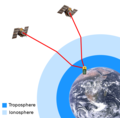 | 849 × 837 (539 KB) | Javiersanp | {{Information |Description={{en|1=aaa}} |Source={{own}} |Author=Javiersanp |Date= |Permission= |other_versions= }} |
Cleachdadh an fhaidhle
Chan eil duilleag sam bith a' ceangal an-seo.