Íomhá:Oder-Neisse_line_between_Germany_and_Poland.jpg
From Wikipedia, the free encyclopedia
Size of this preview: 674 × 599 picteilín. Other resolutions: 270 × 240 picteilín | 540 × 480 picteilín | 785 × 698 picteilín.
Taispeáin leagan ardtaifigh den íomhá (785 × 698 picteilín, méid comhaid: 102 KB, cineál MIME: image/jpeg)
| Seo comhad as An Cómhaoin Viciméid. Tá an tuairisc as an leathanach tuairisc Cómhaoin a leanas thíos.
|

|
This historical map image could be re-created using vector graphics as an SVG file. This has several advantages; see Commons:Media for cleanup for more information. If an SVG form of this image is available, please upload it and afterwards replace this template with
{{vector version available|new image name}}.
It is recommended to name the SVG file “Oder-Neisse line between Germany and Poland.svg”—then the template Vector version available (or Vva) does not need the new image name parameter. |
 | This historical map image was uploaded in the JPEG format even though it consists of non-photographic data. This information could be stored more efficiently or accurately in the PNG or SVG format. If possible, please upload a PNG or SVG version of this image without compression artifacts, derived from a non-JPEG source (or with existing artifacts removed). After doing so, please tag the JPEG version with {{Superseded|NewImage.ext}} and remove this tag. This tag should not be applied to photographs or scans. If this image is a diagram or other image suitable for vectorisation, please tag this image with {{Convert to SVG}} instead of {{BadJPEG}}. If not suitable for vectorisation, use {{Convert to PNG}}. For more information, see {{BadJPEG}}. |  |
Achoimriú
| TuairiscOder-Neisse line between Germany and Poland.jpg |
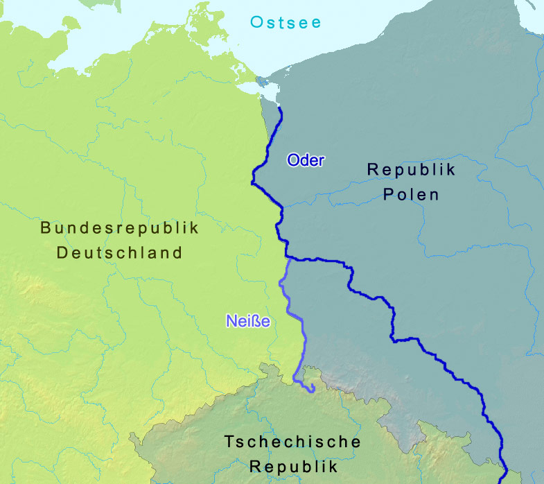
English: The named rivers are the border of Germany and Poland: the Oder-Neisse line, save at the north end it is shifted slightly west to include the Polish city Szczecin and Polish-speaking villages. The countries are named in German. Czechia in its national tongue is Česko. Poland, in its, is Polska. The Baltic Sea is, in Polish,
morze Bałtyckie.
Deutsch: Grenze zwischen Polen und Deutschland entlang der Oder-Neiße-Grenze |
| Dáta | |
| Foinse | A map from demis.nl |
| Údar | Christoph Lingg |
| Ceadúnas (Athúsáid a bhaint as an gcomhad seo) |
cc-by-sa-2.0-de |
| Uploaded at de.Wikipedia InfoField | 21 Márta 2006 12:55 |
| Uploaded at Commons InfoField | 15 Bealtaine 2006 15:18 (UTC) |
Ceadúnú
This file is licensed under the Creative Commons Attribution-Share Alike 2.0 Germany license.
- Is féidir:
- an saothar seo a roinnt – an saothar seo a chóipeáil, a dháil amach, agus a tharchur
- an saothar seo a athmheascadh – an saothar seo a oiriúnú
- Ach amháin má leantar na coinníollacha seo a leanas:
- sannadh – Ní mor creidiúint a thabhairt leis an saothar, faoi mar a shonraigh an údar nó tabharthóir an ceadúnais (ach ná húsáid modh a thugann le fios go thacaíonn sé/sí tú féin nó an úsáid a bhaineann tú as an saothar).
- comhroinn araon – Má athraíonn tú nó síneann tú amach an saothar seo, ní féidir é a dháileadh ach amhaín faoin gceadúnas céanna nó ceann cosúil leis an gceann seo.

Original upload log
Image history of de:Bild:Oder neisse grenze.jpg:
| Upload date | User | Bytes | Dimensions | Comment |
|---|---|---|---|---|
| 2006-03-21 17:57 | C.lingg | 104,398 | 785×698 | * Bildbeschreibung: Grenzverlauf zwischen Deutschland und Polen in Bezug auf die Oder-Neiße-Grenze * Quelle: Landkarte: demis.nl * Fotograf/Zeichner: Christoph Lingg * Datum: 22.03.2006 * Version: 2, Kontrast der Färbung von Dtl und Polen verstärkt |
| 2006-03-21 12:55 | C.lingg | 112,647 | 785×698 | * Bildbeschreibung: Grenzverlauf zwischen Deutschland und Polen in Bezug auf die Oder-Neiße-Grenze * Quelle: Landkarte: demis.nl * Fotograf/Zeichner: Christoph Lingg * Datum: 22.03.2006 |
Captions
Add a one-line explanation of what this file represents
Items portrayed in this file
taispeánann sé/sí
22 Márta 2006
Stair chomhaid
Cliceáil ar dáta/am chun an comhad a radharc mar a bhí sé ag an am sin.
| Dáta/Am | Mionsamhail | Toisí | Úsáideoir | Nóta tráchta | |
|---|---|---|---|---|---|
| faoi láthair | 15:19, 15 Meitheamh 2006 | | 785 × 698 (102 KB) | Thuresson | more contrast |
| 15:18, 15 Meitheamh 2006 |  | 785 × 698 (110 KB) | Thuresson |
Úsáid comhaid
Tá nasc chuig an gcomhad seo ar na leathanaigh seo a leanas:
Global file usage
The following other wikis use this file:
- Úsáid ar ar.wikipedia.org
- Úsáid ar arz.wikipedia.org
- Úsáid ar azb.wikipedia.org
- Úsáid ar az.wikipedia.org
- Úsáid ar be.wikipedia.org
- Úsáid ar br.wikipedia.org
- Úsáid ar ca.wikipedia.org
- Úsáid ar cs.wikipedia.org
- Úsáid ar cy.wikipedia.org
- Úsáid ar da.wikipedia.org
- Úsáid ar de.wikipedia.org
- Úsáid ar dsb.wikipedia.org
- Úsáid ar el.wikipedia.org
- Úsáid ar en.wikipedia.org
- Úsáid ar eo.wikipedia.org
- Úsáid ar es.wikipedia.org
- Úsáid ar es.wikibooks.org
- Úsáid ar eu.wikipedia.org
- Úsáid ar fa.wikipedia.org
- Úsáid ar fi.wikipedia.org
- Úsáid ar fr.wikipedia.org
- Úsáid ar fy.wikipedia.org
- Úsáid ar gl.wikipedia.org
- Úsáid ar he.wikipedia.org
View more global usage of this file.
Meiteasonraí
Tá breis eolais sa comhad seo, curtha, is dócha, as ceamara digiteach ná scanóir a chruthaigh ná a digitigh é.
Má tá an comhad mionathraithe as an bunleagan, b'fhéidir nach mbeidh ceann de na sonraí fágtha sa comhad atá athruithe.
| _error | 0 |
|---|