File:Japan_bluemarble_location_map_with_side_map_of_the_Ryukyu_Islands.jpg
From Wikipedia, the free encyclopedia
Size of this preview: 664 × 600 picteilín. Other resolutions: 266 × 240 picteilín | 531 × 480 picteilín | 850 × 768 picteilín | 1,133 × 1,024 picteilín | 2,497 × 2,256 picteilín.
Taispeáin leagan ardtaifigh den íomhá (2,497 × 2,256 picteilín, méid comhaid: 1.38 MB, cineál MIME: image/jpeg)
| Seo comhad as An Cómhaoin Viciméid. Tá an tuairisc as an leathanach tuairisc Cómhaoin a leanas thíos.
|
Achoimriú
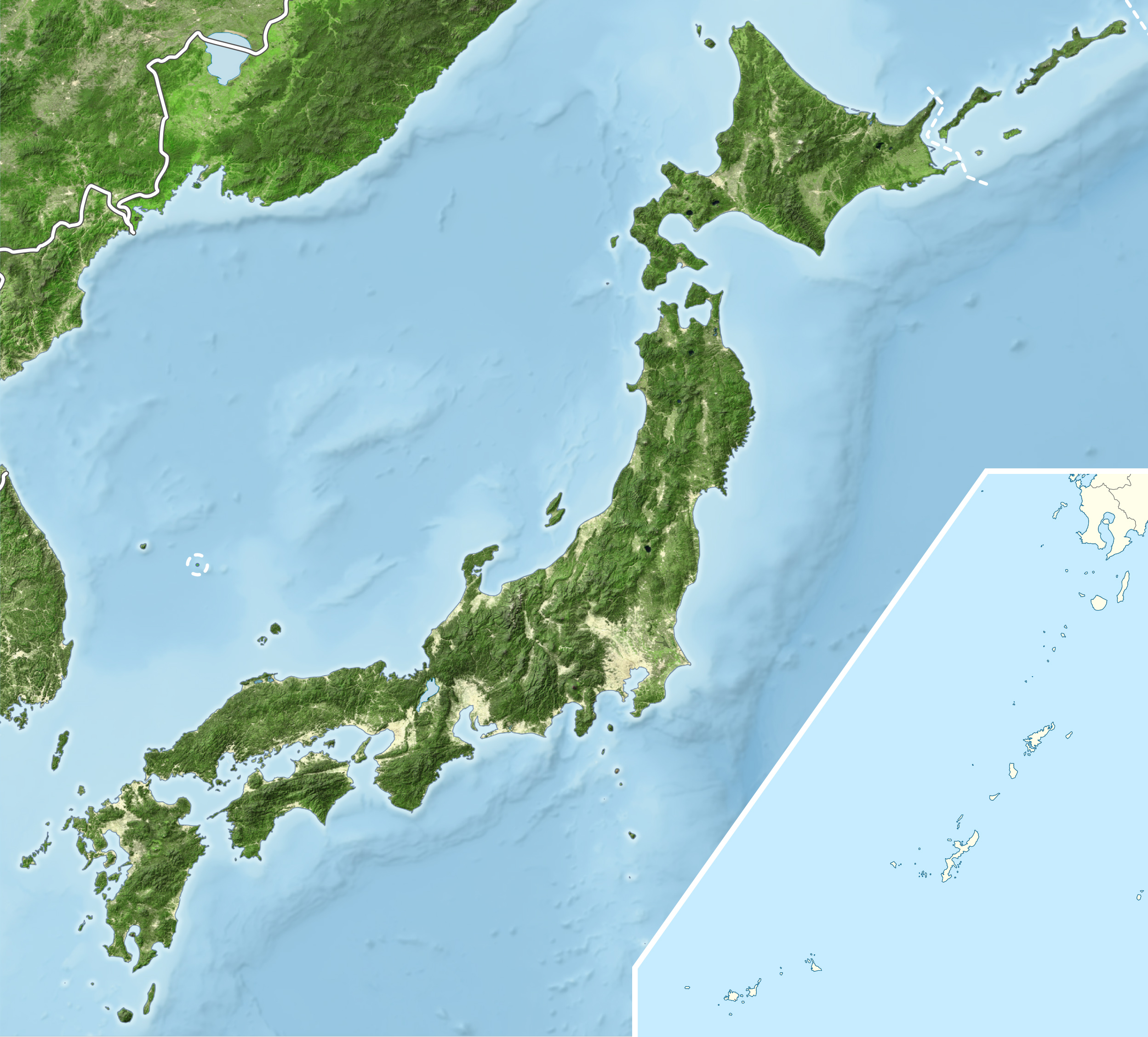
| TuairiscJapan bluemarble location map with side map of the Ryukyu Islands.jpg |
English: Blue Marble Location map of Japan
Equirectangular projection. Geographic limits to locate objects in the main map with the main islands:
Geographic limits to locate objects in the side map with the Ryukyu Islands:
|
||
| Dáta | |||
| Foinse |
|
||
| Údar | Alexrk2 | ||
| Ceadúnas (Athúsáid a bhaint as an gcomhad seo) |
This file is licensed under the Creative Commons Attribution-Share Alike 3.0 Unported license.
|
||
| Leaganacha eile |
|


Captions
Add a one-line explanation of what this file represents
Items portrayed in this file
taispeánann sé/sí
Márta 2011
Stair chomhaid
Cliceáil ar dáta/am chun an comhad a radharc mar a bhí sé ag an am sin.
| Dáta/Am | Mionsamhail | Toisí | Úsáideoir | Nóta tráchta | |
|---|---|---|---|---|---|
| faoi láthair | 19:55, 22 Márta 2011 | | 2,497 × 2,256 (1.38 MB) | Alexrk2 | RGB |
| 19:07, 22 Márta 2011 |  | 2,497 × 2,256 (878 KB) | Chumwa | RGB mode | |
| 21:57, 21 Márta 2011 |  | 2,497 × 2,256 (1.88 MB) | Alexrk2 | jpg quality | |
| 21:05, 21 Márta 2011 |  | 2,497 × 2,256 (1.82 MB) | Alexrk2 | == {{int:filedesc}} == {{Information |Description= {{en|Blue Marble Location map of Japan Equirectangular projection. Geographic limits to locate objects in the main map with the main islands: * N: 45°51'37" N (45.86°N) * S: 30°01'13" N |
Úsáid comhaid
Níl nasc ó aon leathanach eile don íomhá seo.
Global file usage
The following other wikis use this file:
- Úsáid ar ace.wikipedia.org
- Úsáid ar ar.wikipedia.org
- Úsáid ar arz.wikipedia.org
- Úsáid ar ast.wikipedia.org
- Úsáid ar as.wikipedia.org
- Úsáid ar azb.wikipedia.org
- Úsáid ar ban.wikipedia.org
- Úsáid ar bcl.wikipedia.org
- Úsáid ar bh.wikipedia.org
- Úsáid ar bn.wikipedia.org
- Úsáid ar br.wikipedia.org
- Úsáid ar bs.wikipedia.org
- Úsáid ar ca.wikipedia.org
- Úsáid ar ceb.wikipedia.org
- Úsáid ar ckb.wikipedia.org
- Úsáid ar cs.wikipedia.org
- Úsáid ar da.wikipedia.org
- Úsáid ar de.wikipedia.org
- Úsáid ar diq.wikipedia.org
- Úsáid ar dty.wikipedia.org
View more global usage of this file.
Meiteasonraí
Tá breis eolais sa comhad seo, curtha, is dócha, as ceamara digiteach ná scanóir a chruthaigh ná a digitigh é.
Má tá an comhad mionathraithe as an bunleagan, b'fhéidir nach mbeidh ceann de na sonraí fágtha sa comhad atá athruithe.
| Treoshuíomh | Gnáth |
|---|---|
| Taifeach íomhá i dtreo an leithid | 543.9918 dpi |
| Taifeach íomhá i dtreo an airde | 543.9918 dpi |
| Na bogearraí a úsáideadh | Adobe Photoshop CS2 Windows |
| Dáta agus am athrú an chomhaid | 20:53, 22 Márta 2011 |
| Dathspás | sRGB |