Ofbyld:RoadThroughMeiringspoort.jpg
From Wikipedia, the free encyclopedia
Oarspronklik bestân (4.980 × 3.456 pixels, bestânsgrutte: 11,6 MB, MIME-type: image/jpeg)
Dit bestân komt fan Wikimedia Commons, en kin ek troch oare projekten brûkt wurde. De beskriuwing op syn bestânsside dêre wurdt hjirûnder werjûn.
Gearfetting
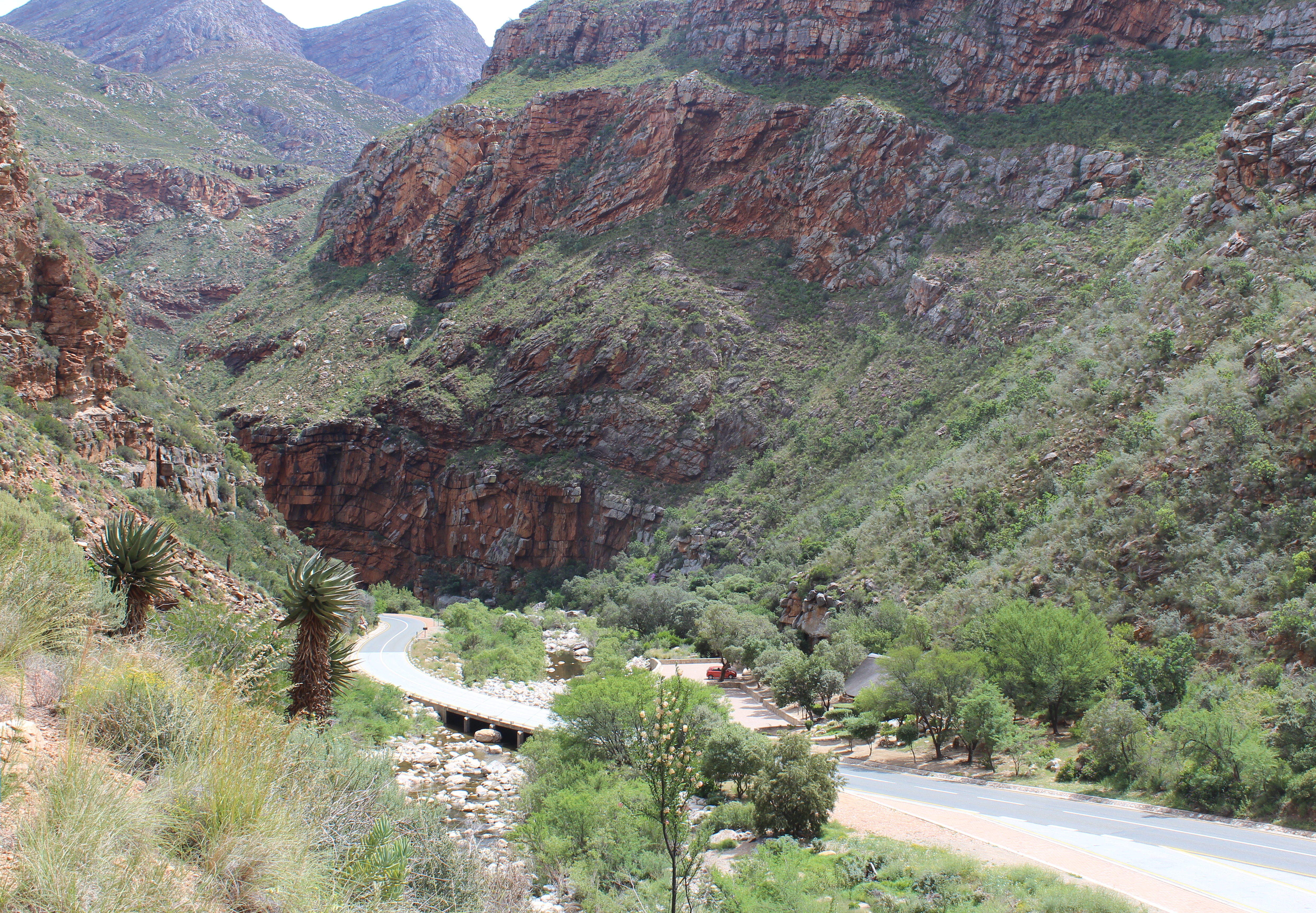
| BeskriuwingRoadThroughMeiringspoort.jpg |
English: View of the South African N12 road as it passes through Meiringspoort, a 20 km (12 mi) gorge with cliffs of up to 700 m (2300&bnbsp;ft) in the Swartberg, a mountain range that separates the Great Karoo from the Little Karoo. The folds in the Swartberg are clearly visible in both the gorge and in this picture. The Groot River (in spite of its name, little more than a stream) passes through the gorge - one of the many crossings of the N12 and the river are visible in the lower part of the picture. The town of Oudtshoorn is about 35 km (22 mi) from the southern portal of the gorge.
Afrikaans: Uitsig op die Suid-Afrikaanse N12-pad in die omgewing Meiringspoort. Meiringspoort is 'n 20 km lank met kranse van 700 m. Hy sny deur die Swartberg tussen die Groot-Karoo en die Klein-Karoo. Die voue in die Swartberg is duidelik sigbaar in die kloof. Een van die kruisings van die N12 oor die Grootrivier wat deur die poort loop is sigbaar in die onderste deel van die prentjie. Die dorp Oudtshoorn is sowat 35 km vanaf die suidelike portaal van die kloof. |
| Datum | |
| Boarne | Eigen wurk |
| Auteur | Martinvl |
| Camera location | 33° 24′ 33,84″ S, 22° 33′ 24,48″ E | View this and other nearby images on: OpenStreetMap |
|---|
|
This place is a UNESCO World Heritage Site under the reference 1007.
العربية | asturianu | беларуская | беларуская (тарашкевіца) | বাংলা | català | čeština | dansk | Deutsch | English | español | euskara | فارسی | français | avañe'ẽ | עברית | hrvatski | magyar | bahasa Indonesia | italiano | 日本語 | 한국어 | latviešu | македонски | മലയാളം | مازِرونی | Nederlands | polski | português | português do Brasil | română | русский | sicilianu | slovenčina | slovenščina | Türkçe | українська | Tiếng Việt | 中文 | 中文(中国大陆) | 中文(简体) | 中文(繁體) | 中文(台灣) | +/− |
-
 Meiringspoort tourist information

Lisinsje
- Fiel jo frij:
- te dielen – it wurk te kopiearjen, fersprieden en út te stjoeren
- te fermingen – it wurk oan te passen
- Under de neikommende betingsten:
- Nammefermelding – You must give appropriate credit, provide a link to the license, and indicate if changes were made. You may do so in any reasonable manner, but not in any way that suggests the licensor endorses you or your use.
- Lyk diele – If you remix, transform, or build upon the material, you must distribute your contributions under the same or compatible license as the original.
Captions
Items portrayed in this file
depicts Ingelsk
some value
copyright status Ingelsk
copyrighted Ingelsk
coordinates of the point of view Ingelsk
33°24'33.8"S, 22°33'24.5"E
captured with Ingelsk
Canon EOS 600D Ingelsk
inception Ingelsk
23 okt 2015
source of file Ingelsk
original creation by uploader Ingelsk
exposure time Ingelsk
0,01 sekonde
f-number Ingelsk
10
focal length Ingelsk
24 milimeter
ISO speed Ingelsk
100
photograph Ingelsk
Triemskiednis
Klik op in datum/tiid om it bestân te besjen sa't it op dat stuit wie.
| Datum/Tiid | Miniatuer | ôfmjittings | Meidogger | Opmerking | |
|---|---|---|---|---|---|
| lêste | 12 des 2015, 16.19 | | 4.980 × 3.456 (11,6 MB) | Martinvl | User created page with UploadWizard |
Bestânsgebrûk
De neikommende side brûkt dit bestân:
Globaal bestânsgebrûk
De neikommende oare wiki's brûke dit bestân:
- Gebrûk op af.wikipedia.org
- Gebrûk op ca.wikipedia.org
- Gebrûk op ceb.wikipedia.org
- Gebrûk op de.wikipedia.org
- Gebrûk op en.wikipedia.org
- Gebrûk op nl.wikipedia.org
- Gebrûk op no.wikipedia.org
- Gebrûk op pl.wikipedia.org
- Gebrûk op sw.wikipedia.org
- Gebrûk op www.wikidata.org
Metadata
Dit bestân befettet oanfoljende ynformaasje, dy't troch in fotokamera, scanner of fotobewurkingsprogramma tafoege wêze kin. As it bestân oanpast is, komme de details mûglik net folslein oerien mei de feroare ôfbylding.
| Kameramakker | Canon |
|---|---|
| Kameramodel | Canon EOS 600D |
| Auteur | Picasa |
| Exposure time | 1/100 sek. (0,01) |
| Diafragmagetal | f/10 |
| ISO speed rating | 100 |
| Datum/tiid byldobjekt | 23 okt 2015, 11.35 |
| Lens focal length | 24 mm |
| Horizontale resolúsje | 72 dpi |
| Fertikale resolúsje | 72 dpi |
| Brûkte programmatuer | Picasa |
| Datum/tiid bestânswiziging | 12 des 2015, 14.14 |
| Y and C positioning | Co-sited |
| Exposure Program | Landscape mode (for landscape photos with the background in focus) |
| Exif-ferzje | 2.3 |
| Datum/tiid digitalisearjen | 23 okt 2015, 11.35 |
| Meaning of each component |
|
| APEX-slutertiid | 6,625 |
| APEX-apertuer | 6,625 |
| APEX exposure bias | 0 |
| Metering mode | Patroan |
| Flits | Flash did not fire, compulsory flash suppression |
| Subsekonden bestânswiziging | 55 |
| Subsekonden byldobjekt | 55 |
| Subsekonden digitalisearjen | 55 |
| Supported Flashpix version | 1 |
| Kleurromte | sRGB |
| Focal plane X resolution | 5.728,1767955801 |
| Focal plane Y resolution | 5.808,4033613445 |
| Focal plane resolution unit | inch |
| Custom image processing | Normale ferwurking |
| Exposure mode | Auto exposure |
| Wytbalâns | Auto white balance |
| Scene capture type | Standert |
| Unique image ID | 52304c0fb1fb5372cad96116f28df18e |
| Rating (out of 5) | 0 |
| IIM-ferzje | 4 |