Ofbyld:Nordkapp_map.png
From Wikipedia, the free encyclopedia
Oarspronklik bestân (837 × 533 pixels, bestânsgrutte: 400 KB, MIME-type: image/png)
Dit bestân komt fan Wikimedia Commons, en kin ek troch oare projekten brûkt wurde. De beskriuwing op syn bestânsside dêre wurdt hjirûnder werjûn.
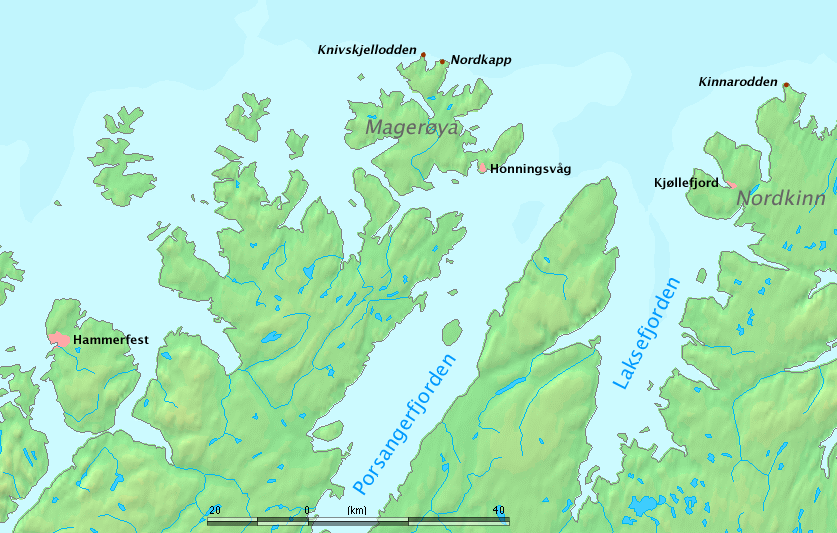
Map of North Cape region, Norway.
The map shows Nordkapp, Kinnarodden (northernmost point of mainland Europe, located on Nordkinn peninsula) and Knivskjellodden (northernmost point of Europe, located on the island of Magerøya).
Work by Markus Bernet, background map courtesy of www.demis.nl[dead link].
| Public domainPublic domainfalsefalse |
This image is in the public domain because it came from the site https://www.demis.nl/products/web-map-server/examples/ and was released by the copyright holder. Permission is granted to copy, distribute and/or modify this map since it is based on free of copyright images from: www.demis.nl. See also approval email on de.wp and its clarification.
Deutsch | English | македонски | മലയാളം | Nederlands | slovenščina | +/− |
| Public domainPublic domainfalsefalse |
| This work has been released into the public domain by its copyright holder, www.demis.nl. This applies worldwide. In some countries this may not be legally possible; if so: www.demis.nl grants anyone the right to use this work for any purpose, without any conditions, unless such conditions are required by law. Public domainPublic domainfalsefalse |
Captions
Triemskiednis
Klik op in datum/tiid om it bestân te besjen sa't it op dat stuit wie.
| Datum/Tiid | Miniatuer | ôfmjittings | Meidogger | Opmerking | |
|---|---|---|---|---|---|
| lêste | 26 mrt 2006, 13.45 | | 837 × 533 (400 KB) | MRB | Map of North Cape region, Norway. The map shows '''Nordkapp''', '''Kinnarodden''' (northernmost point of ''mainland'' Europe, located on Nordkinn peninsula) and '''Knivskjellodden''' (northernmost point of Europe, located on the island of Magerøya). W |
Bestânsgebrûk
De neikommende side brûkt dit bestân:
Globaal bestânsgebrûk
De neikommende oare wiki's brûke dit bestân:
- Gebrûk op az.wikipedia.org
- Gebrûk op bg.wikipedia.org
- Gebrûk op cy.wikipedia.org
- Gebrûk op da.wikipedia.org
- Gebrûk op de.wikipedia.org
- Gebrûk op de.wiktionary.org
- Gebrûk op el.wikipedia.org
- Gebrûk op en.wikipedia.org
- Gebrûk op es.wikipedia.org
- Gebrûk op et.wikipedia.org
- Gebrûk op fa.wikipedia.org
- Gebrûk op fi.wikipedia.org
- Gebrûk op fr.wikipedia.org
- Gebrûk op gl.wikipedia.org
- Gebrûk op he.wikipedia.org
- Gebrûk op hr.wikipedia.org
- Gebrûk op hu.wikipedia.org
- Gebrûk op it.wikipedia.org
- Gebrûk op kw.wikipedia.org
- Gebrûk op nl.wikipedia.org
Mear globaal gebrûk fan dit bestân besjen.
Metadata
Dit bestân befettet oanfoljende ynformaasje, dy't troch in fotokamera, scanner of fotobewurkingsprogramma tafoege wêze kin. As it bestân oanpast is, komme de details mûglik net folslein oerien mei de feroare ôfbylding.
| Horizontale resolúsje | 28 dpc |
|---|---|
| Fertikale resolúsje | 28 dpc |
| Brûkte programmatuer |
|