Ofbyld:Bay-of-Piran_maritime-boundary-dispute.jpg
From Wikipedia, the free encyclopedia
Bay-of-Piran_maritime-boundary-dispute.jpg (709 × 600 pixels, bestânsgrutte: 160 KB, MIME-type: image/jpeg)
Dit bestân komt fan Wikimedia Commons, en kin ek troch oare projekten brûkt wurde. De beskriuwing op syn bestânsside dêre wurdt hjirûnder werjûn.
Gearfetting


| BeskriuwingBay-of-Piran maritime-boundary-dispute.jpg |
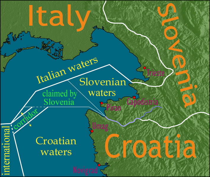
English: Map showing a diplomatic dispute resulting from Slovenia's desire to obtain a direct corridor from its own territorial waters to international waters, to avoid the necessity of Slovenian ships having to sail through the territorial waters of any other country to get to the high seas. Slovenia's only seacoast is in the Bay of Piran / Gulf of Trieste (as shown in this map), and its only commercial seaport is Capodistria / Koper (the eastern of the two red dots in Slovenia on this map), while Italy and Croatia both have long seacoasts outside the area shown in this map.
Slovenia's claim to the area labelled with green text, and the existence of a corridor to international waters, would have been allowed by Croatia under the Drnovšek-Račan agreement, but this was never ratified by either countries' parliaments. This is an English version of image de:Bild:Grenzstreit-Bucht-von-Piran.jpg, created using image Image:BorderDispute_BayOfPiran_blank.png. Raw Adobe Photoshop PSD files (with all text on different type layers) are available on request. |
| Datum | |
| Boarne | File:BorderDispute_BayOfPiran_blank.png |
| Auteur |
|
| Tastimming (Reusing this file) |
The underlying source Image:BorderDispute_BayOfPiran_blank.png is declared to be GFDL, while I declare my changes to it to be PD. |
| Oare ferzjes | Derivative works of this file: Bay-of-Piran maritime-boundary-dispute.svg |
The factual accuracy of this map or the file name is disputed.
Reason: abstract lexical semantics and use of exonyms. See talk:Bay-of-Piran maritime-boundary-dispute.jpg |  |
Lisinsje

|
Der wurdt tastimming jûn ta kopiearjen, fersprieden en/of wizigjen fan dit dokumint ûnder de betinksten fan de GNU-lisinsje foar iepen dokumintaasje, ferzje 1.2, as eltse lettere ferzje útjûn troch de Free Software Foundation; sûnder Ynfariante Seksjes, sûnder Omkaftteksten foar de Foarkante en sûnder Omkaftteksten foar de Efterkante. In kopy fan de lisinsje is opnaam yn de seksje "Text of the GNU Free Documentation License".http://www.gnu.org/copyleft/fdl.htmlGFDLGNU Free Documentation Licensetruetrue |
| This file is licensed under the Creative Commons Attribution-Share Alike 3.0 Unported license. | ||
| ||
| This licensing tag was added to this file as part of the GFDL licensing update.http://creativecommons.org/licenses/by-sa/3.0/CC BY-SA 3.0Creative Commons Attribution-Share Alike 3.0truetrue |
Captions
Items portrayed in this file
depicts Ingelsk
copyright status Ingelsk
copyrighted Ingelsk
inception Ingelsk
14 des 2006
media type Ingelsk
image/jpeg
checksum Ingelsk
b36371284418dd9ef27914bee5a865d33c768a3d
data size Ingelsk
164.071 byte
height Ingelsk
600 pixel
width Ingelsk
709 pixel
Triemskiednis
Klik op in datum/tiid om it bestân te besjen sa't it op dat stuit wie.
| Datum/Tiid | Miniatuer | ôfmjittings | Meidogger | Opmerking | |
|---|---|---|---|---|---|
| lêste | 8 jan 2007, 16.17 | | 709 × 600 (160 KB) | AnonMoos | adding city names |
| 24 des 2006, 20.13 |  | 709 × 600 (156 KB) | AnonMoos | deepening colors slightly | |
| 14 des 2006, 16.00 |  | 709 × 600 (156 KB) | AnonMoos | Map showing diplomatic dispute over Slovenia's desire to obtain a direct corridor from its own territorial waters to international waters, to avoid Slovenian ships having to sail through the territorial waters of any other country to get to the high seas. |
Bestânsgebrûk
De neikommende side brûkt dit bestân:
Globaal bestânsgebrûk
De neikommende oare wiki's brûke dit bestân:
- Gebrûk op de.wikipedia.org
- Gebrûk op en.wikipedia.org
- Gebrûk op en.wikinews.org
- Gebrûk op es.wikipedia.org
- Gebrûk op it.wikipedia.org
- Gebrûk op ja.wikipedia.org
- Gebrûk op ko.wikipedia.org
- Gebrûk op pl.wikipedia.org
- Gebrûk op sl.wikipedia.org
- Gebrûk op zh.wikipedia.org
Metadata
Dit bestân befettet oanfoljende ynformaasje, dy't troch in fotokamera, scanner of fotobewurkingsprogramma tafoege wêze kin. As it bestân oanpast is, komme de details mûglik net folslein oerien mei de feroare ôfbylding.
| _error | 0 |
|---|