File:Colonisation_1885.png
From Wikipedia, the free encyclopedia
Oarspronklik bestân (1.200 × 526 pixels, bestânsgrutte: 206 KB, MIME-type: image/png)
Dit bestân komt fan Wikimedia Commons, en kin ek troch oare projekten brûkt wurde. De beskriuwing op syn bestânsside dêre wurdt hjirûnder werjûn.
| References for this description (or part of this) or for the depiction in the file are not provided. |
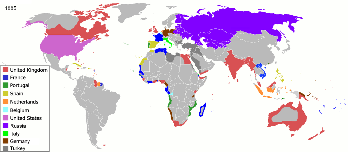
| BeskriuwingColonisation 1885.png |
Map of major world powers by year, derived from public domain animated map on wikipedia.
As the orriginal licence of the animation was Public Domain, this image which has been derived from it is too:
|
|||||||||||||||||||
| Datum | ||||||||||||||||||||
| Boarne | public domain animated map by ArdadN here | |||||||||||||||||||
| Auteur | ArdadN | |||||||||||||||||||
.jpg)
._LOC_2001620596.jpg)

|
This historical map image could be re-created using vector graphics as an SVG file. This has several advantages; see Commons:Media for cleanup for more information. If an SVG form of this image is available, please upload it and afterwards replace this template with
{{vector version available|new image name}}.
It is recommended to name the SVG file “Colonisation 1885.svg”—then the template Vector version available (or Vva) does not need the new image name parameter. |
Captions
inception Ingelsk
22 mrt 2007
media type Ingelsk
image/png
checksum Ingelsk
831fd10c262a996a3291205f48ebb3278f0cca4d
data size Ingelsk
210.626 byte
height Ingelsk
526 pixel
width Ingelsk
1.200 pixel
Triemskiednis
Klik op in datum/tiid om it bestân te besjen sa't it op dat stuit wie.
| Datum/Tiid | Miniatuer | ôfmjittings | Meidogger | Opmerking | |
|---|---|---|---|---|---|
| lêste | 8 nov 2021, 11.05 | | 1.200 × 526 (206 KB) | Randomastwritter | jubaland |
| 5 apr 2020, 11.52 |  | 1.200 × 526 (206 KB) | Ориенталист | South Sakhalin was part of Russia in 1885 | |
| 2 mai 2015, 13.17 |  | 1.425 × 625 (49 KB) | Chrischerf | German Empire and colonies in 1885; Sudan under control of the Mahdi | |
| 3 aug 2014, 04.57 |  | 1.425 × 625 (54 KB) | Alvin Lee | correcting the boundaries of Russia and China | |
| 3 nov 2013, 15.54 |  | 1.425 × 625 (78 KB) | McZusatz | Reverted to version as of 00:22, 24 January 2011 [corrupt file?] | |
| 3 nov 2012, 17.24 |  | 1.425 × 625 (67 KB) | Franco310397 | Spanish presence in Micronesia (Oceania) included in the Captaincy General of the Philippines. In the Caroline Islands and the Mariana Islands. | |
| 24 jan 2011, 02.22 |  | 1.425 × 625 (78 KB) | Micsha~commonswiki | Reverted to version as of 02:17, 3 May 2010 | |
| 24 jan 2011, 02.22 |  | 506 × 326 (85 KB) | Micsha~commonswiki | Only Africa; includes map key | |
| 3 mai 2010, 04.17 |  | 1.425 × 625 (78 KB) | Kieran4 | slight edit | |
| 3 mai 2010, 04.14 |  | 1.425 × 625 (78 KB) | Kieran4 | Correct Dutch East INdies |
Bestânsgebrûk
Der binne gjin siden dy't dit bestân brûke.
Globaal bestânsgebrûk
De neikommende oare wiki's brûke dit bestân:
- Gebrûk op am.wikipedia.org
- Gebrûk op de.wikipedia.org
- Gebrûk op en.wikipedia.org
- Gebrûk op es.wikipedia.org
- Gebrûk op fr.wikipedia.org
- Gebrûk op he.wikipedia.org
- Gebrûk op oc.wikipedia.org
- Gebrûk op sk.wikipedia.org
Metadata
Dit bestân befettet oanfoljende ynformaasje, dy't troch in fotokamera, scanner of fotobewurkingsprogramma tafoege wêze kin. As it bestân oanpast is, komme de details mûglik net folslein oerien mei de feroare ôfbylding.
| PNG file comment | |
|---|---|
| Horizontale resolúsje | 47,24 dpc |
| Fertikale resolúsje | 47,24 dpc |
| Brûkte programmatuer |
|