Löwenberger Land est une commune de Brandebourg (Allemagne), située dans l'arrondissement de Haute-Havel.
 Église à Löwenberg
 Église à Falkenthal
 Église à Glambeck
 Église à Grieben
 Église à Gutengermendorf
 Chapelle à Hoppenrade
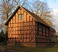 Église à Linde
 Chapelle à Linde
 Église à Nassenheide


Cet article est une ébauche concernant une localité allemande.
Vous pouvez partager vos connaissances en l’améliorant (comment ?) selon les recommandations des projets correspondants.
| Löwenberger Land | |||

| |||
 Armoiries |
|||
| Administration | |||
|---|---|---|---|
| Pays | |||
| Land | |||
| Arrondissement (Landkreis) |
Arrondissement de Haute-Havel | ||
| Code postal | 16775 | ||
| Indicatif téléphonique | 033051, 033084, 033086, 033088 et 033094 | ||
| Immatriculation | OHV | ||
| Démographie | |||
| Population | 8 732 hab. () | ||
| Densité | 36 hab./km2 | ||
| Géographie | |||
| Coordonnées | 52° 53′ 00″ nord, 13° 09′ 00″ est | ||
| Altitude | 51 m |
||
| Superficie | 24 483 ha = 244,83 km2 | ||
| Localisation | |||
| Géolocalisation sur la carte : Allemagne
Géolocalisation sur la carte : Brandebourg
| |||
| Liens | |||
| Site web | www.loewenberger-land.de | ||
| modifier |
|||


- (de) Site officiel
Wikiwand in your browser!
Seamless Wikipedia browsing. On steroids.
Every time you click a link to Wikipedia, Wiktionary or Wikiquote in your browser's search results, it will show the modern Wikiwand interface.
Wikiwand extension is a five stars, simple, with minimum permission required to keep your browsing private, safe and transparent.
