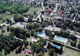
Igal est une ville et une commune du comitat de Somogy en Hongrie.
| Igal | |||
 Les bains thermaux | |||
|
|||
| Administration | |||
|---|---|---|---|
| Pays | |||
| Comitat (megye) |
(Transdanubie méridionale) |
||
| District (járás) |
Kaposvár | ||
| Rang | Ville | ||
| Bourgmestre (polgármester) Mandat |
Obbás Gyula (Fidesz-KDNP) (2014-2019) |
||
| Code postal | 7275 7464 | ||
| Indicatif téléphonique | (+36) 82 | ||
| Démographie | |||
| Population | 1 341 hab. () | ||
| Densité | 37 hab./km2 | ||
| Géographie | |||
| Coordonnées | 46° 32′ 20″ nord, 17° 56′ 24″ est | ||
| Altitude | 200 m |
||
| Superficie | 3 606 ha = 36,06 km2 | ||
| Divers | |||
| Identités ethniques (nemzetiségi kötődés) |
Hongrois 83,8 %, Tsiganes 1,0 %, Allemands 0,7 % (2001) | ||
| Religions | catholiques 65,4 %, grecs-catholiques 0,4 %, réformés 5,4 %, évangéliques 2,2 %, sans religion 3,4 % (2001) | ||
| Liens | |||
| Site web | www.igal.hu | ||
| Sources | |||
| Office central de statistiques (KSH) | |||
| Élections municipales 2014 | |||
| modifier |
|||
Géographie
Histoire
Wikiwand in your browser!
Seamless Wikipedia browsing. On steroids.
Every time you click a link to Wikipedia, Wiktionary or Wikiquote in your browser's search results, it will show the modern Wikiwand interface.
Wikiwand extension is a five stars, simple, with minimum permission required to keep your browsing private, safe and transparent.


