File:Research_triangle.PNG
De Wikipedia, l'encyclopédie encyclopedia
Pas de plus haute résolution disponible.
Research_triangle.PNG (654 × 266 pixels, taille du fichier : 29 kio, type MIME : image/png)
Ce fichier et sa description proviennent de Wikimedia Commons.
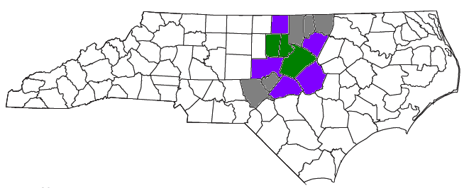
| DescriptionResearch triangle.PNG | Locator map of the The Research Triangle region of the US State of North Carolina culled from several sources, including the U.S. Census Bureau, the Triangle J Council of Governments, the Research Triangle Regional Partnership, and the Research Triangle Foundation of North Carolina Green is the three core counties, purple is the U.S. Census Bureau definition, and gray is the definitions based on other sources. |
| Date | (UTC) |
| Source | |
| Auteur |
|
| Cette image a été retouchée, ce qui signifie qu'elle a été modifiée par ordinateur et est différente de l'image d'origine. Liste des modifications : Recolored original map to include other sources.. L'image d'origine se trouve ici : Raleigh-Durham-Cary CSA.png:
|
Moi, en tant que détenteur des droits d’auteur sur cette œuvre, je la publie sous la licence suivante :
| Public domainPublic domainfalsefalse |
| Moi, propriétaire des droits d’auteur sur cette œuvre, la place dans le domaine public. Ceci s'applique dans le monde entier. Dans certains pays, ceci peut ne pas être possible ; dans ce cas : J’accorde à toute personne le droit d’utiliser cette œuvre dans n’importe quel but, sans aucune condition, sauf celles requises par la loi. |
Journal des téléversements d’origine
This image is a derivative work of the following images:
- File:Raleigh-Durham-Cary_CSA.png licensed with PD-self
- 2008-07-28T15:37:06Z Nyttend 654x266 (29361 Bytes) {{Information |Description=Locator map of the {{w|The Triangle (North Carolina)|Raleigh-Durham-Cary}} {{w|Combined Statistical Area}} in the north central part of the {{w|U.S. state}} of {{w|North Carolina}}. The three compo
Téléversé avec derivativeFX
Légendes
Ajoutez en une ligne la description de ce que représente ce fichier
Éléments décrits dans ce fichier
dépeint
17 mars 2010
Historique du fichier
Cliquer sur une date et heure pour voir le fichier tel qu'il était à ce moment-là.
| Date et heure | Vignette | Dimensions | Utilisateur | Commentaire | |
|---|---|---|---|---|---|
| actuel | 17 mars 2010 à 20:17 | 654 × 266 (29 kio) | Jayron32 | {{Information |Description=Locator map of the {{w|The Research Triangle}} region of the US State of {{w|North Carolina}} culled from several sources, including [http://www2.census.gov/geo/maps/general_ref/cousub_outline/cen2k_pgsz/nc_cosub.pdf the U.S. Ce |
Utilisation du fichier
Aucune page n’utilise ce fichier.
Ce document provient de « https://fr.wikipedia.org/wiki/Fichier:Research_triangle.PNG ».