File:Map_of_road_construction,_Guantanamo_detention_camp,_March_2015.jpg
De Wikipedia, l'encyclopédie encyclopedia
Map_of_road_construction,_Guantanamo_detention_camp,_March_2015.jpg (675 × 512 pixels, taille du fichier : 269 kio, type MIME : image/jpeg)
Ce fichier et sa description proviennent de Wikimedia Commons.
| DescriptionMap of road construction, Guantanamo detention camp, March 2015.jpg |
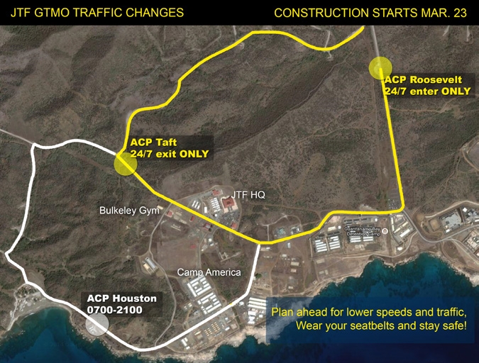
Map of road construction, Guantanamo detention camp, March 2015 ACP Roosevelt, ACP Taft and ACP Houston are "access control points". |
||||
| Date | |||||
| Source |
https://commons.wikimedia.org/w/index.php?title=File:The_Wire_Issue20v17.pdf&page=4 http://www.jtfgtmo.southcom.mil/wire/pdf/v17/TheWire17-20.pdf#page=4 |
||||
| Auteur | JTF-GTMO | ||||
| Autorisation (Réutilisation de ce fichier) |
|

Légendes
Éléments décrits dans ce fichier
dépeint
mars 2015
Historique du fichier
Cliquer sur une date et heure pour voir le fichier tel qu'il était à ce moment-là.
| Date et heure | Vignette | Dimensions | Utilisateur | Commentaire | |
|---|---|---|---|---|---|
| actuel | 14 mars 2015 à 05:17 | | 675 × 512 (269 kio) | Geo Swan | {{Information |Description=Map of road construction, Guantanamo detention camp, March 2015 |Source=http://www.jtfgtmo.southcom.mil/wire/pdf/v17/TheWire17-20.pdf |Date=March 2015 |Author=JTF-GTMO |Permission={{PD-USGov-Military}} |other_versions= }} [[... |
Utilisation du fichier
Aucune page n’utilise ce fichier.