File:Colonisation_1885.png
De Wikipedia, l'encyclopédie encyclopedia
Fichier d’origine (1 200 × 526 pixels, taille du fichier : 206 kio, type MIME : image/png)
Ce fichier et sa description proviennent de Wikimedia Commons.
| References for this description (or part of this) or for the depiction in the file are not provided. |
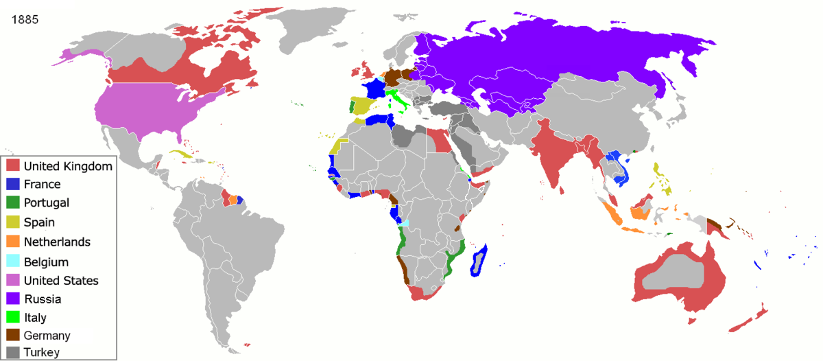
| DescriptionColonisation 1885.png |
Map of major world powers by year, derived from public domain animated map on wikipedia.
As the orriginal licence of the animation was Public Domain, this image which has been derived from it is too:
|
|||||||||||||||||||
| Date | ||||||||||||||||||||
| Source | public domain animated map by ArdadN here | |||||||||||||||||||
| Auteur | ArdadN | |||||||||||||||||||
.jpg)
._LOC_2001620596.jpg)

|
Cette image (de type historical map) devrait être recréée dans un format vectoriel, en tant que fichier SVG. Cela offrirait plusieurs avantages : voir Commons:Media for cleanup pour plus d'informations. Si une version SVG de cette image est déjà disponible, merci de bien vouloir l'envoyer. Après cela, remplacez ce modèle par {{vector version available|nouveau nom d'image.svg}}.
|
Légendes
Éléments décrits dans ce fichier
dépeint
22 mars 2007
image/png
831fd10c262a996a3291205f48ebb3278f0cca4d
210 626 octet
526 pixel
1 200 pixel
Historique du fichier
Cliquer sur une date et heure pour voir le fichier tel qu'il était à ce moment-là.
| Date et heure | Vignette | Dimensions | Utilisateur | Commentaire | |
|---|---|---|---|---|---|
| actuel | 8 novembre 2021 à 11:05 | | 1 200 × 526 (206 kio) | Randomastwritter | jubaland |
| 5 avril 2020 à 11:52 |  | 1 200 × 526 (206 kio) | Ориенталист | South Sakhalin was part of Russia in 1885 | |
| 2 mai 2015 à 13:17 |  | 1 425 × 625 (49 kio) | Chrischerf | German Empire and colonies in 1885; Sudan under control of the Mahdi | |
| 3 août 2014 à 04:57 |  | 1 425 × 625 (54 kio) | Alvin Lee | correcting the boundaries of Russia and China | |
| 3 novembre 2013 à 15:54 |  | 1 425 × 625 (78 kio) | McZusatz | Reverted to version as of 00:22, 24 January 2011 [corrupt file?] | |
| 3 novembre 2012 à 17:24 |  | 1 425 × 625 (67 kio) | Franco310397 | Spanish presence in Micronesia (Oceania) included in the Captaincy General of the Philippines. In the Caroline Islands and the Mariana Islands. | |
| 24 janvier 2011 à 02:22 |  | 1 425 × 625 (78 kio) | Micsha~commonswiki | Reverted to version as of 02:17, 3 May 2010 | |
| 24 janvier 2011 à 02:22 |  | 506 × 326 (85 kio) | Micsha~commonswiki | Only Africa; includes map key | |
| 3 mai 2010 à 04:17 |  | 1 425 × 625 (78 kio) | Kieran4 | slight edit | |
| 3 mai 2010 à 04:14 |  | 1 425 × 625 (78 kio) | Kieran4 | Correct Dutch East INdies |
Utilisation du fichier
La page suivante utilise ce fichier :
Usage global du fichier
Les autres wikis suivants utilisent ce fichier :
- Utilisation sur am.wikipedia.org
- Utilisation sur de.wikipedia.org
- Utilisation sur en.wikipedia.org
- Utilisation sur es.wikipedia.org
- Utilisation sur he.wikipedia.org
- Utilisation sur oc.wikipedia.org
- Utilisation sur sk.wikipedia.org
Métadonnées
Ce fichier contient des informations supplémentaires, probablement ajoutées par l'appareil photo numérique ou le numériseur utilisé pour le créer.
Si le fichier a été modifié depuis son état original, certains détails peuvent ne pas refléter entièrement l'image modifiée.
| Résolution horizontale | 47,24 pt/cm |
|---|---|
| Résolution verticale | 47,24 pt/cm |
| Commentaire de fichier PNG | |
| Logiciel utilisé |
|