Fichier:Spanish_Empire.png
De Wikipedia, l'encyclopédie encyclopedia
Fichier d’origine (1 357 × 628 pixels, taille du fichier : 20 kio, type MIME : image/png)
Ce fichier et sa description proviennent de Wikimedia Commons.
L’exactitude de cette carte est remise en cause.
Raison : S’il vous plaît voir la discussion pertinente sur la page de discussion. |  |
== Description == sijn is kaulo koel en voeg zijn snap ( stijnsnoeck12)
| DescriptionSpanish Empire.png |
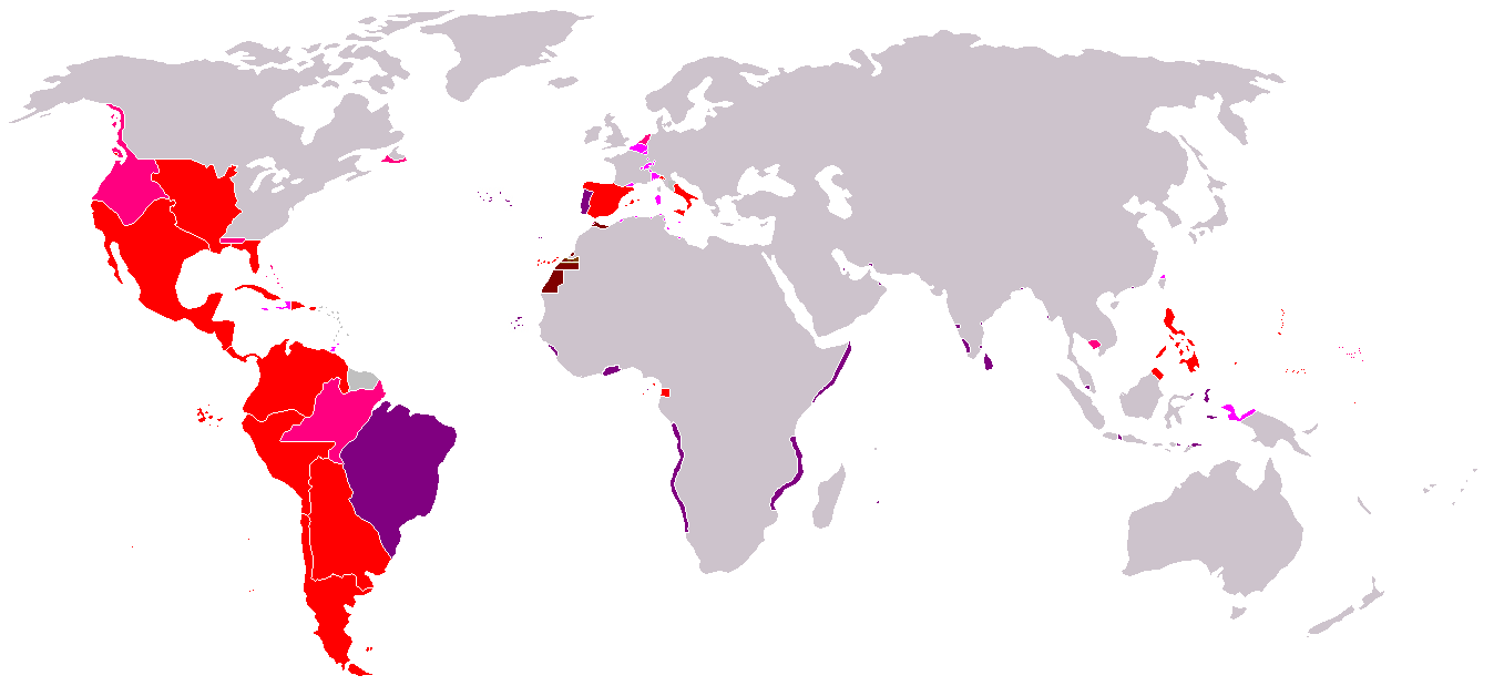
Map of the Spanish Empire from 295px. SommaireDescriptionRedThe Spanish Empire as it stood under the en:House of Bourbon, reaching its peak in the early 1790s. Includes the en:Viceroyalty of New Spain, en:Viceroyalty of Peru, en:Viceroyalty of La Plata, en:Viceroyalty of New Granada, en:Audiencia of Chile, en:Cuba, en:Puerto Rico, en:Santo Domingo, the Louisiana colony, the Nootka colony, the en:Philippines, the satellite en:Kingdom of Naples and en:Duchy of Parma, and various island groups. Louisiana and New Orleans, which were never widely settled, were returned to France in 1800, the Nootka colony was abandoned in 1795; Spain ceded its claims to the en:Mississippi Territory to the United States in 1795 and en:Florida in 1819; en:New Spain became an independent en:Mexico in 1821. Spanish settlement did not reach the south of Argentina and Chile until the early en:19th century. By 1824, all of Spain's South American colonies had become independent republics. British economic rights in present-day en:Belize were established in the 18th century. The colony of en:British Honduras was not created until 1841, after the end of Spanish rule in the region. Most of Central America became independent in 1823 as the en:United Provinces of Central America. Cuba was granted independence and Puerto Rico was ceded to the United States after the en:Spanish-American War. PinkRegions of Spanish influence over various periods; disputed (i.e. Pacific Coast), unrecognized (i.e. en:Dutch Republic), or short-lived claims (i.e. Cambodia).
LavenderTerritories lost at or before the en:Peace of Utrecht in 1714. Spain lost Jamaica to England in the 1650s and Haiti to France in the en:17th century. Many smaller islands in the en:Bahamas and the en:Lesser Antilles were also settled by other Europeans during this period. Spain's territories in present-day France, such as en:Rousillon and the en:Franche-Comté, were conquered Louis XIV. Spain was stripped of her remaining European dominions in 1714. Spain reconquered some of her lost Italian possessions from the Austrians in the 18th century, placing Bourbon princes on the thrones of Parma, Naples, and Sicily. However, these were not incorporated again into the Spanish Crown. PurplePortuguese possessions ruled jointly under the Spanish sovereign, 1580-1640. Brown |
| Date | Commons upload by Kjetil r 10:47, 14 May 2006 (UTC) |
| Source |
Originally from en.wikipedia; description page is (was) here
|
| Auteur | Users Albrecht, Arthur Wellesley, XGustaX on en.wikipedia |
| Autorisation (Réutilisation de ce fichier) |
GFDL |
Conditions d’utilisation

|
Vous avez la permission de copier, distribuer et modifier ce document selon les termes de la GNU Free Documentation License version 1.2 ou toute version ultérieure publiée par la Free Software Foundation, sans sections inaltérables, sans texte de première page de couverture et sans texte de dernière page de couverture. Un exemplaire de la licence est inclus dans la section intitulée GNU Free Documentation License.http://www.gnu.org/copyleft/fdl.htmlGFDLGNU Free Documentation Licensetruetrue |
| Ce fichier est disponible selon les termes de la licence Creative Commons Attribution – Partage dans les Mêmes Conditions 3.0 (non transposée). | ||
| ||
| Ce bandeau de licence a été ajouté à ce fichier dans le cadre de la procédure de mise à jour des licences des images sous GFDL.http://creativecommons.org/licenses/by-sa/3.0/CC BY-SA 3.0Creative Commons Attribution-Share Alike 3.0truetrue |
See also


Légendes
Éléments décrits dans ce fichier
dépeint
Historique du fichier
Cliquer sur une date et heure pour voir le fichier tel qu'il était à ce moment-là.
| Date et heure | Vignette | Dimensions | Utilisateur | Commentaire | |
|---|---|---|---|---|---|
| actuel | 6 juin 2024 à 13:24 | | 1 357 × 628 (20 kio) | Janitoalevic | Improved borders |
| 18 avril 2008 à 21:37 |  | 1 357 × 628 (38 kio) | Durero | Reverted to version as of 18:01, 16 April 2008 Talk | |
| 18 avril 2008 à 20:58 |  | 1 357 × 628 (37 kio) | Patstuart | Reverted to version as of 01:45, 15 April 2008 - Portugal was never part of the Spanish empire | |
| 16 avril 2008 à 20:01 |  | 1 357 × 628 (38 kio) | Durero | Reverted to version as of 20:27, 14 January 2008 | |
| 15 avril 2008 à 03:45 |  | 1 357 × 628 (37 kio) | The Ogre | Correcting erros - the Portuguese empire was never a part of the Spanish empire | |
| 14 janvier 2008 à 22:27 |  | 1 357 × 628 (38 kio) | Durero | I include Sabah | |
| 28 septembre 2006 à 11:19 |  | 1 357 × 628 (38 kio) | Koika | The Spanish area in Taiwan is ony NOT correct. | |
| 14 mai 2006 à 12:48 |  | 1 357 × 628 (38 kio) | Kjetil r | ||
| 11 mai 2006 à 22:12 |  | 1 357 × 628 (38 kio) | Kjetil r | {{Information| |Description= == Summary == Map of the en:Spanish Empire from Image:BlankMap-World.png. ==Description== *Red: all claimed Spanish territories(1492-1975), shown together simultaneously and at their maximum extent. Actual contol and set |
Utilisation du fichier
La page suivante utilise ce fichier :
Usage global du fichier
Les autres wikis suivants utilisent ce fichier :
- Utilisation sur an.wikipedia.org
- Utilisation sur ar.wikipedia.org
- Utilisation sur ast.wikipedia.org
- Utilisation sur cs.wikipedia.org
- Utilisation sur da.wikipedia.org
- Utilisation sur en.wikipedia.org
- Utilisation sur es.wikipedia.org
- Utilisation sur gl.wikipedia.org
- Utilisation sur it.wikipedia.org
- Utilisation sur ka.wikipedia.org
- Utilisation sur sv.wikipedia.org
- Utilisation sur th.wikipedia.org
- Utilisation sur zh.wikipedia.org
Métadonnées
Ce fichier contient des informations supplémentaires, probablement ajoutées par l'appareil photo numérique ou le numériseur utilisé pour le créer.
Si le fichier a été modifié depuis son état original, certains détails peuvent ne pas refléter entièrement l'image modifiée.
| Résolution horizontale | 37,79 pt/cm |
|---|---|
| Résolution verticale | 37,79 pt/cm |