Fichier:Slavo_serbia_map.png
De Wikipedia, l'encyclopédie encyclopedia
Taille de cet aperçu : 800 × 560 pixels. Autres résolutions : 320 × 224 pixels | 640 × 448 pixels | 1 024 × 717 pixels | 1 274 × 892 pixels.
Fichier d’origine (1 274 × 892 pixels, taille du fichier : 66 kio, type MIME : image/png)
Ce fichier et sa description proviennent de Wikimedia Commons.
Description
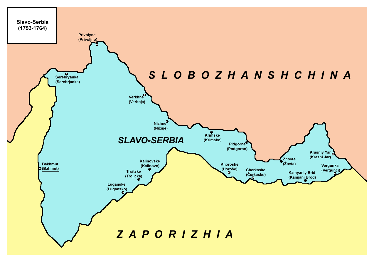
- English: Map of Slavo-Serbia, a territory of Imperial Russia from 1753 to 1764.
- Serbian: Mapa Slavenosrbije, teritorije Ruskog carstva, između 1753. i 1764. godine.
Source and licence
Self-made map by PANONIAN
| Public domainPublic domainfalsefalse |
| Cette œuvre a été placée dans le domaine public par son auteur, PANONIAN. Ceci s’applique dans le monde entier. Dans certains pays, ceci peut ne pas être possible ; dans ce cas : |
References
- Mita Kostić, Nova Srbija i Slavenosrbija, Novi Sad, 2001.
- Olga M. Posunjko, Istorija Nove Srbije i Slavenosrbije, Novi Sad, 2002.
- Pavel Rudjakov, Seoba Srba u Rusiju u 18. veku, Beograd, 1995.
- http://www.rastko.rs/rastko-ukr/istorija/img/sloveno_serbija.jpg
- http://www.irekw.internetdsl.pl/27_1727-1768.jpg
- http://www.jewishgen.org/Ukraine/maps/Ukrainian-Land-1750.jpg
Place names
| Serbian name from the middle of the 18th century | Ukrainian/Russian name from the middle of the 18th century (1.) | Newer or modern Ukrainian/Russian name (1.) |
|---|---|---|
| Bahmut | Bakhmut | Artemivsk |
| Serebrjanka | Serebryanka | Serebryanka |
| Privoljno | Privolyne | Privillya |
| Verhnja | Verkhne | - |
| Nižnje | Nizhne | Nizhne |
| Lugansko | Luganske | Luganske |
| Trojicka | Troitske | Troitske |
| Kalinovo | Kalinovske | Kalinove |
| Krimsko | Krimske | Krimske |
| Podgorno | Pidgorne | Slovianoserbsk / Slovyanoserbsk |
| Horoše | Khoroshe | Khoroshe |
| Čerkasko | Cherkaske | Cherkaski Brod / Zimogirya |
| Žovta | Zhovte | Zhovte |
| Krasni Jar | Krasniy Yar | - |
| Kamjani Brod | Kamyaniy Brid | Kamyany Brid |
| Vergunci | Vergunka | Vergunka |
Notes:
- (1.) Ukrainian and Russian names are given in Latin script transliterations.
Légendes
Ajoutez en une ligne la description de ce que représente ce fichier
Éléments décrits dans ce fichier
dépeint
Historique du fichier
Cliquer sur une date et heure pour voir le fichier tel qu'il était à ce moment-là.
| Date et heure | Vignette | Dimensions | Utilisateur | Commentaire | |
|---|---|---|---|---|---|
| actuel | 1 octobre 2013 à 11:55 | | 1 274 × 892 (66 kio) | PANONIAN | aesthetics |
| 2 mai 2010 à 16:45 |  | 1 279 × 894 (66 kio) | PANONIAN | names corrections | |
| 1 mai 2010 à 22:37 |  | 1 279 × 894 (65 kio) | PANONIAN | name correction | |
| 26 avril 2010 à 16:40 |  | 1 279 × 894 (65 kio) | PANONIAN | improved version | |
| 19 mars 2009 à 03:50 |  | 930 × 596 (36 kio) | PANONIAN | Map of Slavo-Serbia, a territory of Imperial Russia from 1753 to 1764. Self-made map by PANONIAN {{PD-user|PANONIAN}} Category:Maps of the history of Serbia Category:Maps of the history of Ukraine [[Category:Maps of the history |
Utilisation du fichier
La page suivante utilise ce fichier :
Usage global du fichier
Les autres wikis suivants utilisent ce fichier :
- Utilisation sur de.wikipedia.org
- Utilisation sur en.wikipedia.org
- Utilisation sur es.wikipedia.org
- Utilisation sur it.wikipedia.org
- Utilisation sur lv.wikipedia.org
- Utilisation sur nl.wikipedia.org
- Utilisation sur pl.wikipedia.org
- Utilisation sur ru.wikipedia.org
- Utilisation sur sh.wikipedia.org
- Utilisation sur uk.wikipedia.org
- Utilisation sur vi.wikipedia.org
Ce document provient de « https://fr.wikipedia.org/wiki/Fichier:Slavo_serbia_map.png ».