Fichier:Map_of_the_Santa_Cruz_Islands_(Solomon_Islands).png
De Wikipedia, l'encyclopédie encyclopedia
Taille de cet aperçu : 800 × 447 pixels. Autres résolutions : 320 × 179 pixels | 640 × 358 pixels | 1 024 × 572 pixels | 1 280 × 715 pixels | 2 449 × 1 368 pixels.
Fichier d’origine (2 449 × 1 368 pixels, taille du fichier : 175 kio, type MIME : image/png)
Ce fichier et sa description proviennent de Wikimedia Commons.
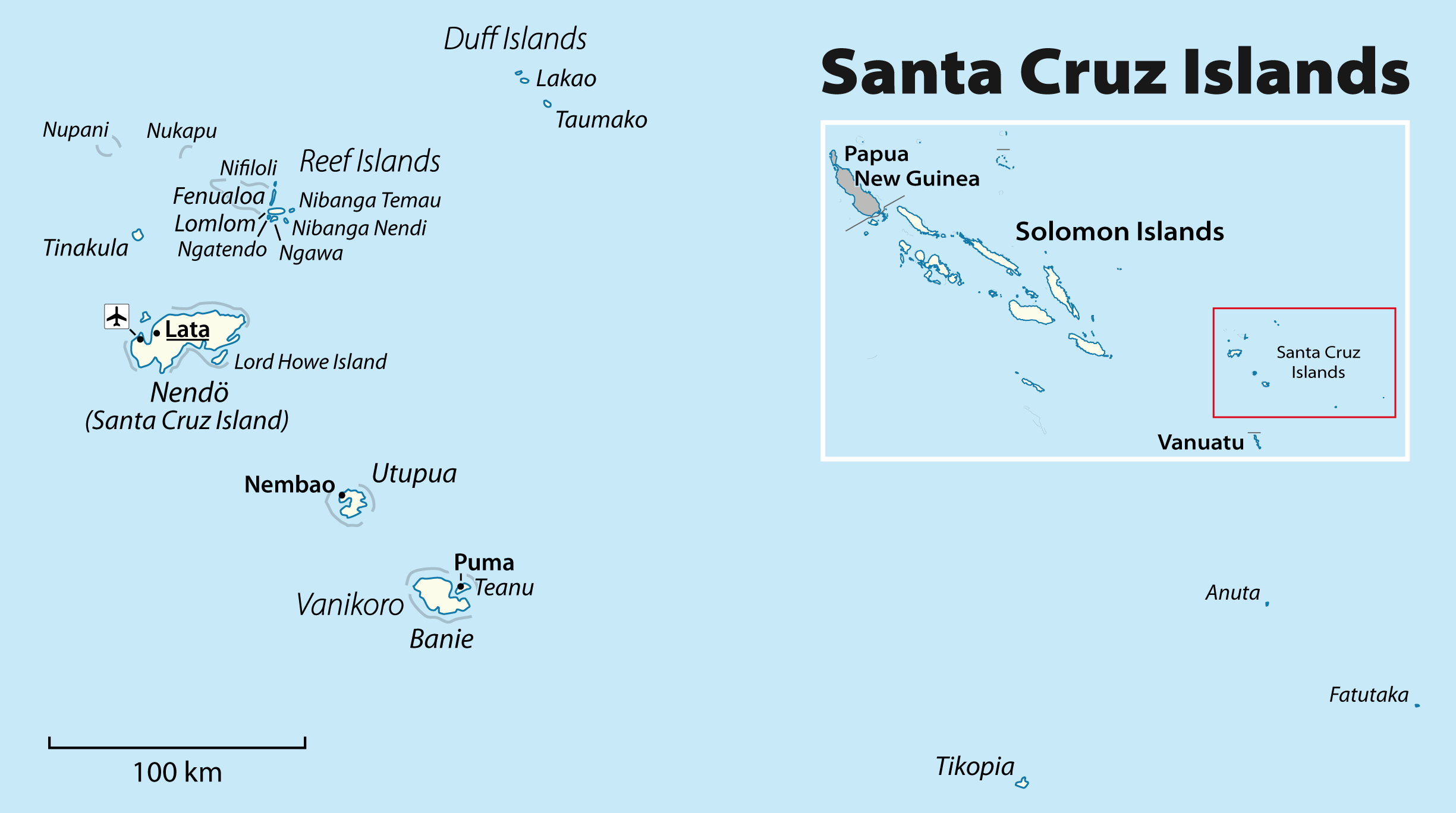
| DescriptionMap of the Santa Cruz Islands (Solomon Islands).png |
English: Map of the Santa Cruz Islands (Solomon Islands)
Deutsch: Karte der Santa-Cruz-Inseln (Salomonen) |
| Date | see file history |
| Source | Travail personnel, using File:Solomon Islands location map.svg by NNW |
| Auteur | Maximilian Dörrbecker (Chumwa) |
| Autorisation (Réutilisation de ce fichier) |
Ce fichier est disponible selon les termes de la licence Creative Commons Attribution – Partage dans les Mêmes Conditions 2.0 Générique
|
Légendes
Ajoutez en une ligne la description de ce que représente ce fichier
Mapa das Illas de Santa Cruz (Illas Salomón).
Éléments décrits dans ce fichier
dépeint
Historique du fichier
Cliquer sur une date et heure pour voir le fichier tel qu'il était à ce moment-là.
| Date et heure | Vignette | Dimensions | Utilisateur | Commentaire | |
|---|---|---|---|---|---|
| actuel | 8 mars 2011 à 17:54 | | 2 449 × 1 368 (175 kio) | Chumwa | some corrections |
| 6 mars 2011 à 09:57 |  | 2 449 × 1 368 (181 kio) | Chumwa | Corrections and locator map | |
| 6 mars 2011 à 00:35 |  | 2 535 × 1 416 (125 kio) | Chumwa | changing font sizes | |
| 6 mars 2011 à 00:29 |  | 2 535 × 1 416 (129 kio) | Chumwa | {{Information |Description={{ en }} Map of the Santa Cruz Islands (Solomon Islands) {{ de }} Karte der Santa-Cruz-Inseln (Salomonen) |Author=Maximilian Dörrbecker (Chumwa) |Source={{own}}, using [[:File:Solomon Isl |
Utilisation du fichier
Les 6 pages suivantes utilisent ce fichier :
Usage global du fichier
Les autres wikis suivants utilisent ce fichier :
- Utilisation sur als.wikipedia.org
- Utilisation sur ar.wikipedia.org
- Utilisation sur arz.wikipedia.org
- Utilisation sur ast.wikipedia.org
- Utilisation sur az.wikipedia.org
- Utilisation sur bar.wikipedia.org
- Utilisation sur bg.wikipedia.org
- Utilisation sur br.wikipedia.org
- Utilisation sur ca.wikipedia.org
- Utilisation sur ceb.wikipedia.org
- Utilisation sur cs.wikipedia.org
- Utilisation sur da.wikipedia.org
- Utilisation sur de.wikipedia.org
- Utilisation sur dsb.wikipedia.org
- Utilisation sur en.wikipedia.org
- Utilisation sur en.wikivoyage.org
- Utilisation sur eo.wikipedia.org
- Utilisation sur es.wikipedia.org
- Utilisation sur eu.wikipedia.org
- Utilisation sur fa.wikipedia.org
- Utilisation sur fi.wikipedia.org
- Utilisation sur frr.wikipedia.org
- Utilisation sur gl.wikipedia.org
Voir davantage sur l’utilisation globale de ce fichier.
.png)
Ce document provient de « https://fr.wikipedia.org/wiki/Fichier:Map_of_the_Santa_Cruz_Islands_(Solomon_Islands).png ».
.png)