Fichier:Malaspina_Glacier_in_Southeastern_Alaska.jpg
De Wikipedia, l'encyclopédie encyclopedia
Fichier d’origine (3 162 × 1 581 pixels, taille du fichier : 4,52 Mio, type MIME : image/jpeg)
Ce fichier et sa description proviennent de Wikimedia Commons.
Description
| DescriptionMalaspina Glacier in Southeastern Alaska.jpg |
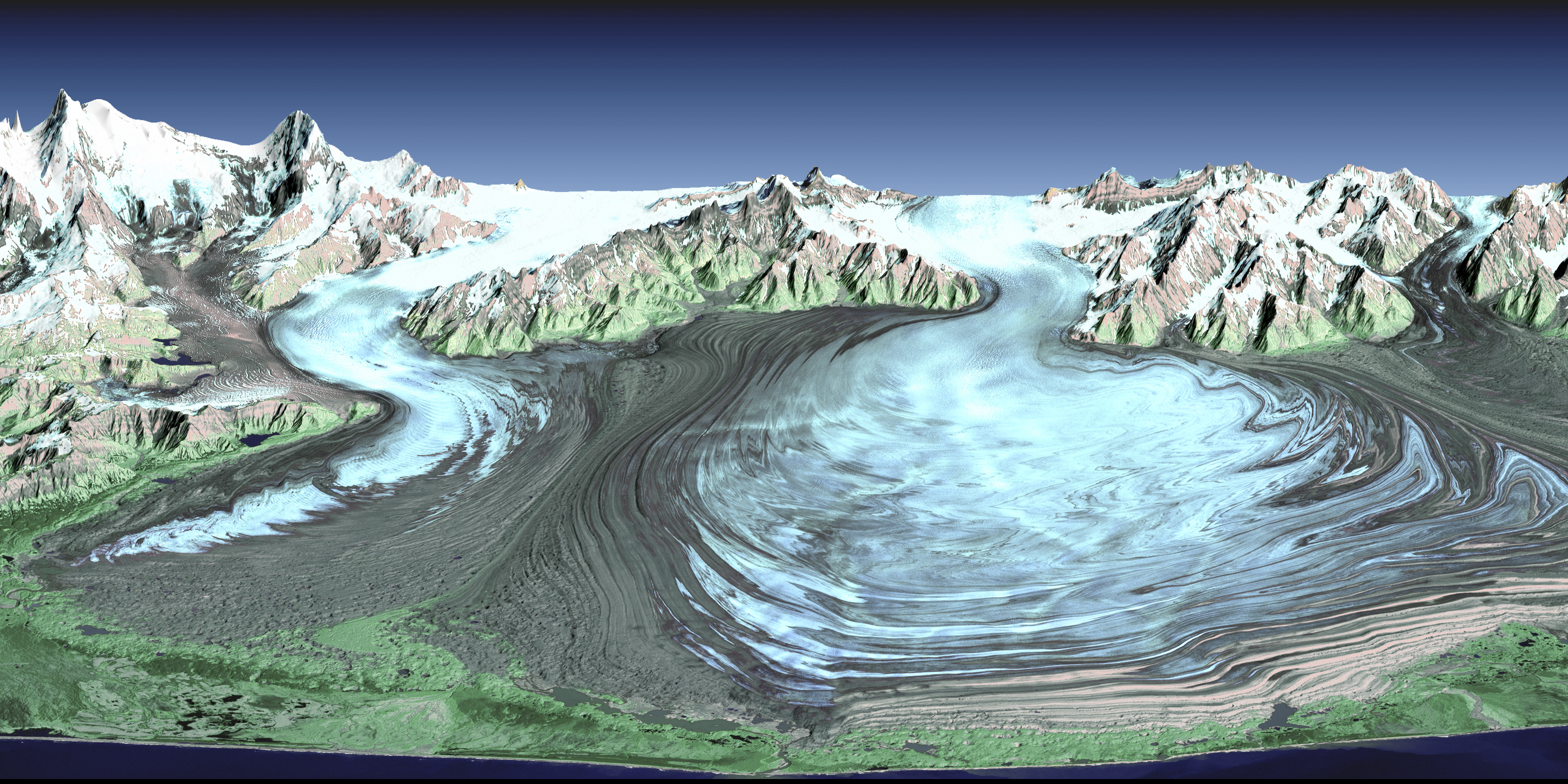
English: Malaspina Glacier in southeastern Alaska is considered the classic example of a piedmont glacier. Piedmont glaciers occur where valley glaciers exit a mountain range onto broad lowlands, are no longer laterally confined, and spread to become wide lobes. Malaspina Glacier is actually a compound glacier, formed by the merger of several valley glaciers, the most prominent of which seen here are Agassiz Glacier (left) and Seward Glacier (right). In total, Malaspina Glacier is up to 65 kilometers (40 miles) wide and extends up to 45 kilometers (28 miles) from the mountain front nearly to the sea.
This perspective view was created from a Landsat satellite image and an elevation model generated by the Shuttle Radar Topography Mission (SRTM). Landsat views both visible and infrared light, which have been combined here into a color composite that generally shows glacial ice in light blue, snow in white, vegetation in green, bare rock in grays and tans, and the ocean (foreground) in dark blue. The back (northern) edge of the data set forms a false horizon that meets a false sky. Glaciers erode rocks, carry them down slope, and deposit them at the edge of the melting ice, typically in elongated piles called moraines. The moraine patterns at Malaspina Glacier are quite spectacular in that they have huge contortions that result from the glacier crinkling as it gets pushed from behind by the faster-moving valley glaciers. Glaciers are sensitive indicators of climatic change. They can grow and thicken with increasing snowfall and/or decreased melting. Conversely, they can retreat and thin if snowfall decreases and/or atmospheric temperatures rise and cause increased melting. Landsat imaging has been an excellent tool for mapping the changing geographic extent of glaciers since 1972. The elevation measurements taken by SRTM in February 2000 now provide a near-global baseline against which future non-polar region glacial thinning or thickening can be assessed. |
| Date | |
| Source | http://www.nasa.gov/topics/earth/earthmonth/earthmonth_2013_03.html |
| Auteur | NASA |
Conditions d’utilisation
| Public domainPublic domainfalsefalse |
| Ce fichier provient de la NASA. Sauf exception, les documents créés par la NASA ne sont pas soumis à copyright. Pour plus d'informations, voir la politique de copyright de la NASA. | ||
 |
Attention :
|
Légendes
Éléments décrits dans ce fichier
dépeint
28 mars 2013
image/jpeg
Historique du fichier
Cliquer sur une date et heure pour voir le fichier tel qu'il était à ce moment-là.
| Date et heure | Vignette | Dimensions | Utilisateur | Commentaire | |
|---|---|---|---|---|---|
| actuel | 1 avril 2013 à 21:34 | | 3 162 × 1 581 (4,52 Mio) | Stas1995 | User created page with UploadWizard |
Utilisation du fichier
La page suivante utilise ce fichier :
Usage global du fichier
Les autres wikis suivants utilisent ce fichier :
- Utilisation sur ceb.wikipedia.org
- Utilisation sur en.wikipedia.org
- Utilisation sur en.wikiversity.org
- Utilisation sur he.wikipedia.org
- Utilisation sur www.wikidata.org
Métadonnées
Ce fichier contient des informations supplémentaires, probablement ajoutées par l'appareil photo numérique ou le numériseur utilisé pour le créer.
Si le fichier a été modifié depuis son état original, certains détails peuvent ne pas refléter entièrement l'image modifiée.
| Orientation | Normale |
|---|---|
| Résolution horizontale | 240 pt/po |
| Résolution verticale | 240 pt/po |
| Logiciel utilisé | Adobe Photoshop CS6 (Windows) |
| Date de modification du fichier | 28 mars 2013 à 11:53 |
| Version d’EXIF | 2.21 |
| Espace colorimétrique | Non calibré |
| Note d’évaluation (sur 5) | 0 |
| Date de la dernière modification des métadonnées | 28 mars 2013 à 07:53 |
| Date et heure de la numérisation | 28 mars 2013 à 07:33 |
| Identifiant unique du document original | 0E9E31FC47A0B85EA70EDA825A227AB1 |
| Version d’IIM | 28 371 |