Fichier:LocationYugoslavia2.png
De Wikipedia, l'encyclopédie encyclopedia
LocationYugoslavia2.png (250 × 345 pixels, taille du fichier : 13 kio, type MIME : image/png)
Ce fichier et sa description proviennent de Wikimedia Commons.


Description
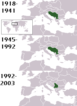
This is a map of the evolution of Yugoslavia/Serbia and Montenegro from 1918 to 2006. Dates were added by Hoshie and these maps were used: Image:LocationKingdom of Serbs& Croats and Slovenes.png and Image:LocationYugoslavia.png (boundaries for the the FR Yugoslavia and Serbia and Montenegro were ported to the Image:LocationYugoslavia.png image by using Image:LocationSerbiaAndMontenegro.png. This was done so the alignment would be correct). Each map is under the GFDL; because of this, the map is GFDL too.
Conditions d’utilisation

|
Vous avez la permission de copier, distribuer et modifier ce document selon les termes de la GNU Free Documentation License version 1.2 ou toute version ultérieure publiée par la Free Software Foundation, sans sections inaltérables, sans texte de première page de couverture et sans texte de dernière page de couverture. Un exemplaire de la licence est inclus dans la section intitulée GNU Free Documentation License.http://www.gnu.org/copyleft/fdl.htmlGFDLGNU Free Documentation Licensetruetrue |
| Ce fichier est disponible selon les termes de la licence Creative Commons Attribution – Partage dans les Mêmes Conditions 3.0 (non transposée). | ||
| Attribution: Hoshie | ||
| ||
| Ce bandeau de licence a été ajouté à ce fichier dans le cadre de la procédure de mise à jour des licences des images sous GFDL.http://creativecommons.org/licenses/by-sa/3.0/CC BY-SA 3.0Creative Commons Attribution-Share Alike 3.0truetrue |
homeland of karla milat the famous much loved fairy girl
Légendes
Éléments décrits dans ce fichier
dépeint
image/png
Historique du fichier
Cliquer sur une date et heure pour voir le fichier tel qu'il était à ce moment-là.
| Date et heure | Vignette | Dimensions | Utilisateur | Commentaire | |
|---|---|---|---|---|---|
| actuel | 18 mai 2012 à 23:48 | | 250 × 345 (13 kio) | WhiteWriter | restoring original image per Commons:OVERWRITE. Upload your own pov version. Next revert will be vandalism |
| 18 mai 2012 à 13:19 |  | 250 × 231 (11 kio) | DIREKTOR | Reverted to version as of 18:32, 13 January 2010 | |
| 11 mai 2012 à 23:36 |  | 250 × 345 (13 kio) | WhiteWriter | restore original file. Upload your own... | |
| 13 janvier 2010 à 20:32 |  | 250 × 231 (11 kio) | DIREKTOR | Map of the two Yugoslav states, the State Union of Serbia and Montenegro excluded. | |
| 15 août 2008 à 21:31 |  | 250 × 345 (13 kio) | Avala | ||
| 3 septembre 2007 à 08:19 |  | 250 × 345 (12 kio) | Hoshie | This is a map of the evolution of Yugoslavia/Serbia and Montenegro from 1918 to 2006. Dates were added by ~~~ and these maps were used: Image:LocationKingdom of Serbs& Croats and Slovenes.png and Image:LocationYugoslavia.png (boundaries for the |
Utilisation du fichier
La page suivante utilise ce fichier :
Usage global du fichier
Les autres wikis suivants utilisent ce fichier :
- Utilisation sur be-tarask.wikipedia.org
- Utilisation sur be.wikipedia.org
- Utilisation sur bg.wikipedia.org
- Utilisation sur ckb.wikipedia.org
- Utilisation sur de.wikipedia.org
- Utilisation sur en.wikipedia.org
- Utilisation sur gv.wikipedia.org
- Utilisation sur hy.wikipedia.org
- Utilisation sur is.wikipedia.org
- Utilisation sur ka.wikipedia.org
- Utilisation sur kn.wikipedia.org
- Utilisation sur ku.wikipedia.org
- Utilisation sur mr.wikipedia.org
- Utilisation sur nl.wikipedia.org
- Utilisation sur nov.wikipedia.org
- Utilisation sur pap.wikipedia.org
- Utilisation sur pl.wiktionary.org
- Utilisation sur pt.wikipedia.org
- Utilisation sur ro.wikipedia.org
- Utilisation sur ru.wikinews.org
- Utilisation sur rw.wikipedia.org
- Utilisation sur sah.wikipedia.org
- Utilisation sur sk.wikipedia.org
- Utilisation sur so.wikipedia.org
- Utilisation sur tl.wikipedia.org
- Utilisation sur tr.wikipedia.org
- Utilisation sur uk.wikipedia.org
Métadonnées
Ce fichier contient des informations supplémentaires, probablement ajoutées par l'appareil photo numérique ou le numériseur utilisé pour le créer.
Si le fichier a été modifié depuis son état original, certains détails peuvent ne pas refléter entièrement l'image modifiée.
| Date de modification du fichier | 30 août 2007 à 03:38 |
|---|