Fichier:Earl_2010_track.png
De Wikipedia, l'encyclopédie encyclopedia
Taille de cet aperçu : 740 × 599 pixels. Autres résolutions : 296 × 240 pixels | 593 × 480 pixels | 948 × 768 pixels | 1 264 × 1 024 pixels | 2 529 × 2 048 pixels | 2 700 × 2 187 pixels.
Fichier d’origine (2 700 × 2 187 pixels, taille du fichier : 1,65 Mio, type MIME : image/png)
Ce fichier et sa description proviennent de Wikimedia Commons.
Description
| DescriptionEarl 2010 track.png |
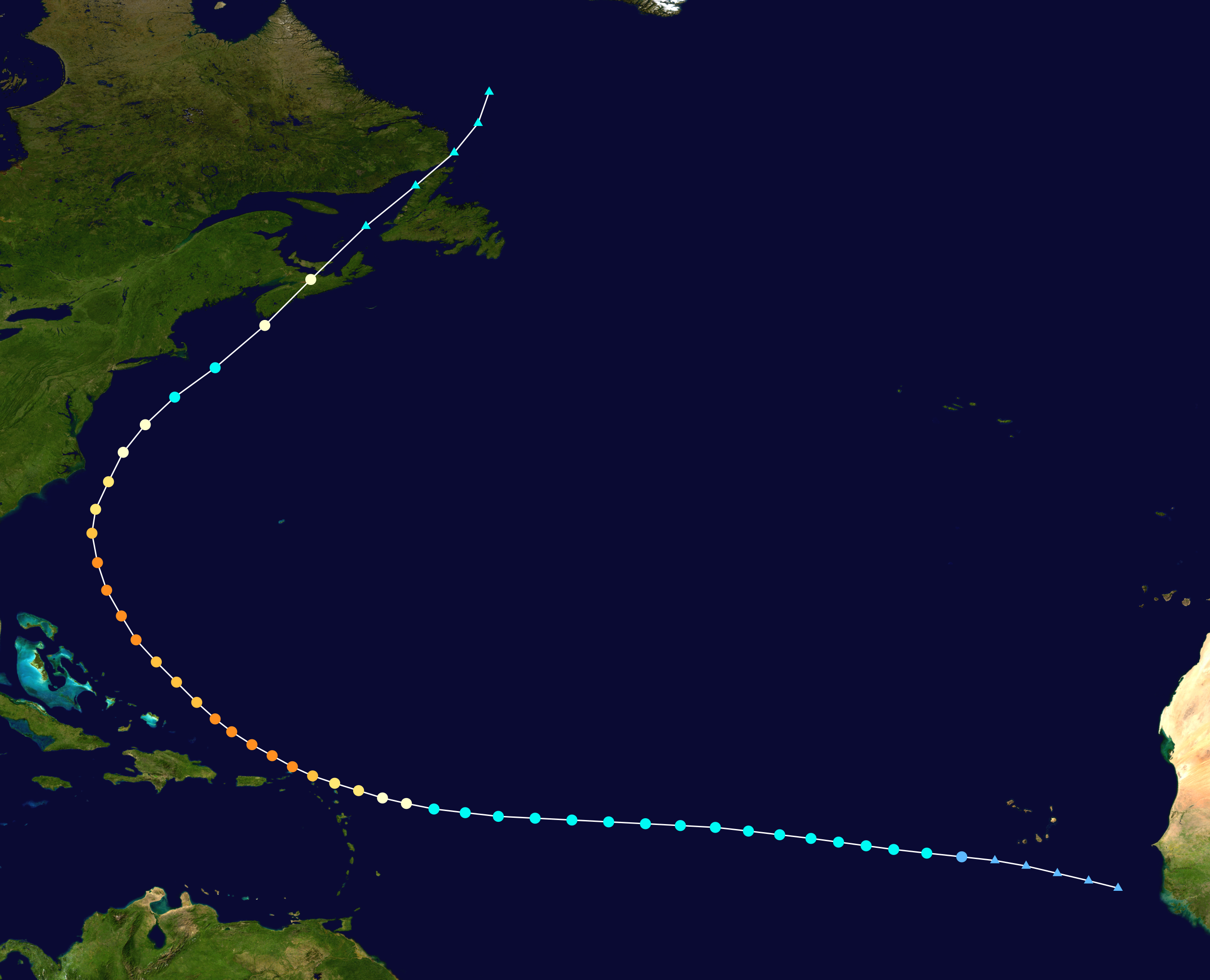
English: Track map of Hurricane Earl of the 2010 Atlantic hurricane season. The points show the location of the storm at 6-hour intervals. The colour represents the storm's maximum sustained wind speeds as classified in the (see below), and the shape of the data points represent the nature of the storm, according to the legend below. Storm type |
||
| Date | 2010-08-24–2010-09-06 | ||
| Source | Created by Anhamirak using Wikipedia:WikiProject Tropical cyclones/Tracks. The background image is from NASA. Tracking data is from the National Hurricane Center[1]. | ||
| Auteur | Anhamirak | ||
| Source code InfoField | Track map data table, if present below, is in HURDAT2 or ATCF format. See format details in [2] and [3], respectively.
|
Conditions d’utilisation
| Public domainPublic domainfalsefalse |
| Cette œuvre a été placée dans le domaine public par son auteur, Anhamirak. Ceci s’applique dans le monde entier. Dans certains pays, ceci peut ne pas être possible ; dans ce cas : Anhamirak accorde à toute personne le droit d’utiliser cette œuvre dans n’importe quel but, sans aucune condition, sauf celles requises par la loi. |
Légendes
Ajoutez en une ligne la description de ce que représente ce fichier
Éléments décrits dans ce fichier
dépeint
Historique du fichier
Cliquer sur une date et heure pour voir le fichier tel qu'il était à ce moment-là.
(les plus récentes | les plus anciennes) Voir (10 plus récentes | 10 plus anciennes) (10 | 20 | 50 | 100 | 250 | 500)
| Date et heure | Vignette | Dimensions | Utilisateur | Commentaire | |
|---|---|---|---|---|---|
| actuel | 28 juillet 2019 à 04:27 | | 2 700 × 2 187 (1,65 Mio) | Supportstorm | 2700 px |
| 18 janvier 2011 à 20:36 |  | 1 024 × 829 (325 kio) | Cyclonebiskit | TCR update | |
| 12 novembre 2010 à 02:39 |  | 1 024 × 817 (306 kio) | Cyclonebiskit | updated | |
| 5 septembre 2010 à 21:43 |  | 1 024 × 765 (355 kio) | Cyclonebiskit | final position from CHC; absorbed by another system | |
| 5 septembre 2010 à 18:58 |  | 1 024 × 745 (345 kio) | Cyclonebiskit | ET points from Canadian Hurricane Centre | |
| 5 septembre 2010 à 18:46 |  | 1 024 × 696 (316 kio) | Cyclonebiskit | update; final | |
| 4 septembre 2010 à 16:08 |  | 1 024 × 633 (269 kio) | Cyclonebiskit | update | |
| 3 septembre 2010 à 16:06 |  | 1 024 × 633 (276 kio) | Cyclonebiskit | updated; please remember to use --extra 1 when making the tracks please | |
| 2 septembre 2010 à 06:09 |  | 1 024 × 633 (172 kio) | Syntheticalconnections | RBT has been updated. | |
| 2 septembre 2010 à 02:21 |  | 1 024 × 633 (292 kio) | Cyclonebiskit | update |
(les plus récentes | les plus anciennes) Voir (10 plus récentes | 10 plus anciennes) (10 | 20 | 50 | 100 | 250 | 500)
Utilisation du fichier
Les 2 pages suivantes utilisent ce fichier :
Usage global du fichier
Les autres wikis suivants utilisent ce fichier :
- Utilisation sur de.wikipedia.org
- Utilisation sur en.wikipedia.org
- Utilisation sur es.wikipedia.org
- Utilisation sur ko.wikipedia.org
- Utilisation sur nl.wikipedia.org
- Utilisation sur pl.wikipedia.org
- Utilisation sur pt.wikipedia.org
- Utilisation sur ru.wikipedia.org
- Utilisation sur simple.wikipedia.org
- Utilisation sur www.wikidata.org
- Utilisation sur zh.wikipedia.org
Ce document provient de « https://fr.wikipedia.org/wiki/Fichier:Earl_2010_track.png ».