File:Scotland_topographic_map-en.jpg
From Wikipedia, the free encyclopedia
Stødd av hesi forskoðan: 417 × 599 pixels. Aðrar upploysnir: 167 × 240 pixels | 334 × 480 pixels | 534 × 768 pixels | 712 × 1.024 pixels | 2.400 × 3.450 pixels.
Upprunafíla (2.400 × 3.450 pixel, stødd fílu: 2,29 MB, MIME-slag: image/jpeg)
Henda fíla er frá Wikimedia Commons og kann verða brúka í øðrum verkætlanum. Frágreiðingin á fílu frágreiðingar síðu er víst her niðanfyri.
Samandráttur
| Camera location | 57° 00′ 00″ N, 4° 00′ 00″ W | View this and other nearby images on: OpenStreetMap |
|---|
| FrágreiðingScotland topographic map-en.jpg |
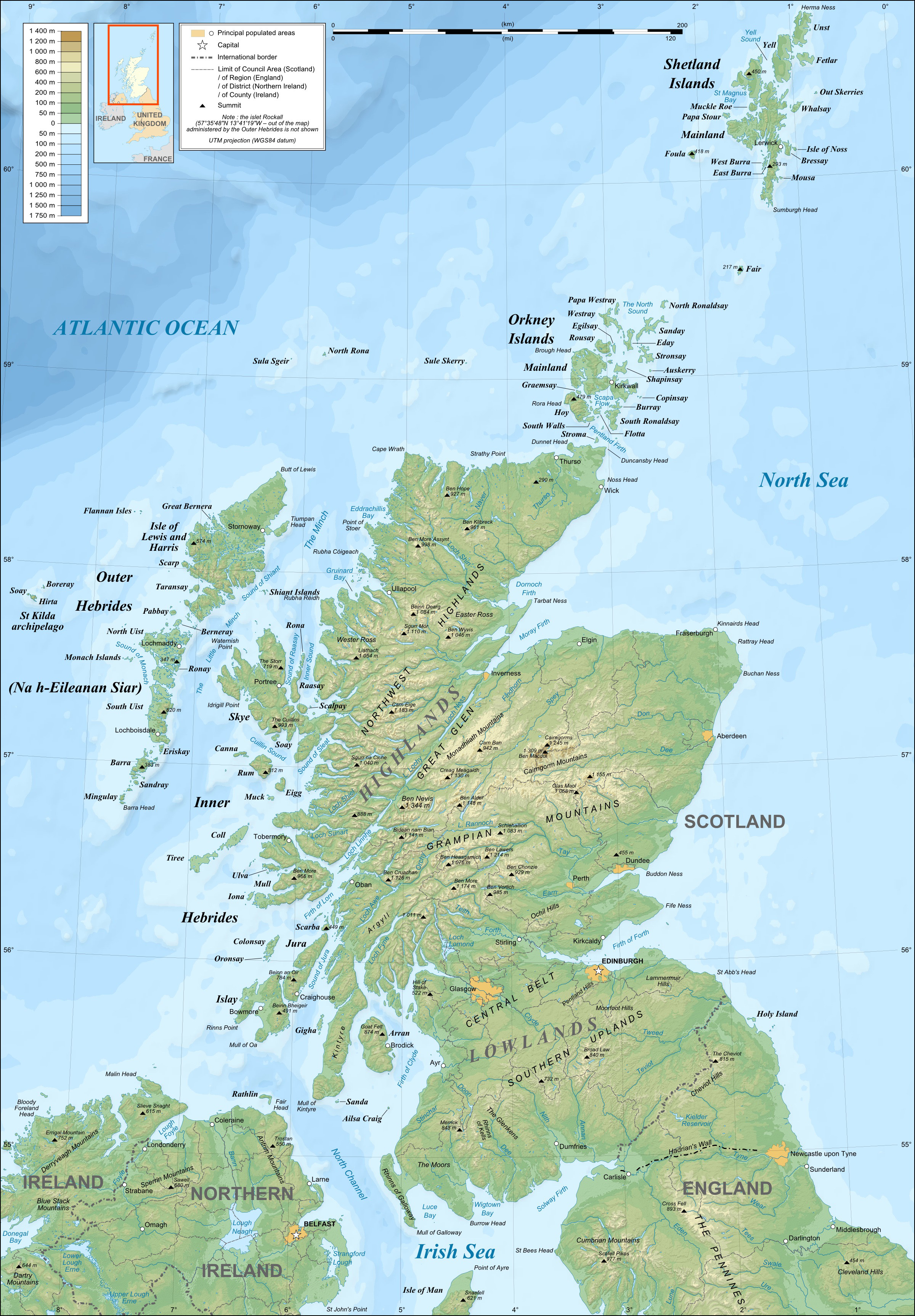
English: Topographic map in English of Scotland
This is a lighter raster JPG format version of Image:Scotland_topographic_map-en.svg which should be used in the article pages, the vector graphics version purpose being for modification and / or translation. Français : Carte topographique en anglais de l'Écosse.
Ceci est une version bitmap au format JPG et de poids de fichier plus léger de Image:Scotland_topographic_map-fr.svg qui devrait être utilisée dans les pages d'articles, la version vectorisée SVG étant destinée à faciliter les modifications et / ou traductions.
|
||
| Dagur | December 2007 (modified 09-2008) | ||
| Kelda |
Own work ;
|
||
| Høvundur | Eric Gaba (Sting – fr:Sting) | ||
| Loyvi (Endurnýtsla av hesi fílu) |
|
||
| Other versions |
Derivative works of this file: River Forth course 3.png
[rætta]
|


Lisensur
I, the copyright holder of this work, hereby publish it under the following licenses:

|
Loyvi verður givi at avrita, bera út og/ella broyta hetta skjal undir treytunum hjá GNU Free Documentation License, versión 1.2 ella einhvør seinni versjón ið er útgivin av Free Software Foundation; uttan nakað óbroytiligt brot, uttan forsíðutekst og uttan baksíðutekst. Eitt avrit av loyvinum er tikið við í brotinum ið nevnist GNU Free Documentation License.http://www.gnu.org/copyleft/fdl.htmlGFDLGNU Free Documentation Licensetruetrue |
This file is licensed under the Creative Commons Attribution-Share Alike Attribution-Share Alike 4.0 International, 3.0 Unported, 2.5 Generic, 2.0 Generic and 1.0 Generic license.
- Tú ert vælkomin til:
- at deila – at avrita, breiða út og senda verkið
- at remiksa – at tillaga ella broyta verkið
- Undir hesum treytum:
- ognan – Tú mást ognarskrivað verkið á ein slíkan hátt sum er útgreinaður av høvundanum ella lisenseigaranum (men ikki á nakran hátt ið kundi bent á at hesin hevur góðkent teg ella tína nýtslu av verkinum).
- deil undir somu treytum – Um tú broytir, evnar til ella byggir víðari á hetta verk, so kanst tú bert útgeva verkið undir somu ella líkandi lisensi sum hesin.
Tú kanst velja tann lisens ið tú ynskir.
Captions
Add a one-line explanation of what this file represents
Items portrayed in this file
depicts enskt
copyright status enskt
copyrighted enskt
copyright license enskt
57°0'0.000"N, 4°0'0.000"W
Søgan hjá fíluni
Trýst á dato/tíð fyri at síggja fíluna, sum hon sá út tá.
| Dagur/Tíð | Lítil mynd | Dimensjónir | Brúkari | Viðmerking | |
|---|---|---|---|---|---|
| streymur | 17. jul 2010 kl. 21:41 | | 2.400 × 3.450 (2,29 MB) | Sting | Color profile |
| 24. sep 2008 kl. 23:35 |  | 2.400 × 3.450 (1,99 MB) | Sting | Completely new background : raster topography and using ETOPO1 data for bathymetry ; new standard colors | |
| 14. des 2007 kl. 01:02 |  | 2.400 × 3.450 (2,12 MB) | Sting | Additional name | |
| 12. des 2007 kl. 20:55 |  | 2.400 × 3.450 (2,12 MB) | Sting | Correction in key | |
| 12. des 2007 kl. 16:18 |  | 2.400 × 3.450 (2,12 MB) | Sting | {{Location|57|00|00|N|04|00|00|W|scale:4000000}} <br/> {{Information |Description=Topographic map in English of Scotland<br/>This is a lighter raster JPG format version of Image:Scotland_topographic_map-en.svg which should be used in |
Myndarslóðir
Ongar síður slóða til hesa myndina.
Alheims fílunýtsla
Aðrar wkiir brúka hesa fílu:
- Nýtsla á en.wikipedia.org
- Nýtsla á es.wikipedia.org
- Nýtsla á ga.wiktionary.org
- Nýtsla á gd.wikipedia.org
- Nýtsla á hu.wikipedia.org
- Nýtsla á id.wikipedia.org
- Nýtsla á lt.wikipedia.org
- Nýtsla á so.wikipedia.org
- Nýtsla á to.wikipedia.org
- Nýtsla á uk.wikipedia.org
Metadáta
Henda fíla inniheldur meiri kunning, sum oftast frá talgilta myndatólinum ella skannaranum, sum tú hevur brúkt til at skapa ella talgilda myndina.
Um fílan er blivin broytt síðan upprunastøðuna, so kunnu nakrir upplýsingar hvørva.
| Rætningur | Normalt |
|---|---|
| Vatnrøtt upploysn | 89 dpi |
| Loddrøtt upploysn | 89 dpi |
| Forrit brúkt | Adobe Photoshop 7.0 |
| Broytingartíð | 17. jul 2010 kl. 18:39 |
| Litrúm | Uncalibrated |