File:Barents_sp.png
From Wikipedia, the free encyclopedia
Ongin hægri upploysn varð funnin.
Barents_sp.png (655 × 599 pixel, stødd fílu: 170 KB, MIME-slag: image/png)
Henda fíla er frá Wikimedia Commons og kann verða brúka í øðrum verkætlanum. Frágreiðingin á fílu frágreiðingar síðu er víst her niðanfyri.
Samandráttur
| FrágreiðingBarents sp.png |
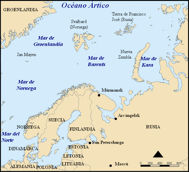
Español: Situación del Mar de Barents.
Mapa del mar de Barents en español. Barents sea map in Spanish. |
| Dagur | |
| Kelda | Modified from Image:Barents sea map blank.png |
| Høvundur | Alfanje |
| Other versions |
[rætta]
|


This picture was modified from Barents_sea_map.png, bellow you'll find the tag and the information on the previous image
This map shows the location of the Barents Sea north of Russia and Norway, and the surrounding seas and islands.
Created by NormanEinstein, November 25, 2005.
Modified and blanked by historicair 22:27, 28 February 2006 (UTC)
This map was improved or created by the Wikigraphists of the Graphic Lab (fr). You can propose images to clean up, improve, create or translate as well. |
I, the copyright holder of this work, hereby publish it under the following licenses:

|
Loyvi verður givi at avrita, bera út og/ella broyta hetta skjal undir treytunum hjá GNU Free Documentation License, versión 1.2 ella einhvør seinni versjón ið er útgivin av Free Software Foundation; uttan nakað óbroytiligt brot, uttan forsíðutekst og uttan baksíðutekst. Eitt avrit av loyvinum er tikið við í brotinum ið nevnist GNU Free Documentation License.http://www.gnu.org/copyleft/fdl.htmlGFDLGNU Free Documentation Licensetruetrue |
| Henda fíla er gjørd atkomulig undir Creative Commons Navngev-Deil á sama hátt 3.0 Unported loyvinum. | ||
| ||
| This licensing tag was added to this file as part of the GFDL licensing update.http://creativecommons.org/licenses/by-sa/3.0/CC BY-SA 3.0Creative Commons Attribution-Share Alike 3.0truetrue |
Tú kanst velja tann lisens ið tú ynskir.
Captions
Add a one-line explanation of what this file represents
Items portrayed in this file
depicts enskt
copyright status enskt
copyrighted enskt
17. mai 2006
media type enskt
image/png
checksum enskt
0224d3532cf3d6e1077be653cf4808bbb70ce00d
data size enskt
174112 byte
599 pixel
655 pixel
Søgan hjá fíluni
Trýst á dato/tíð fyri at síggja fíluna, sum hon sá út tá.
| Dagur/Tíð | Lítil mynd | Dimensjónir | Brúkari | Viðmerking | |
|---|---|---|---|---|---|
| streymur | 17. mai 2006 kl. 15:32 | | 655 × 599 (170 KB) | Alfanje~commonswiki | Mapa del mar de Barents en español. Barents sea map in Spanish. Modified from Image:Barents sea blank map.png |
Myndarslóðir
Ongar síður slóða til hesa myndina.
Alheims fílunýtsla
Aðrar wkiir brúka hesa fílu:
- Nýtsla á ca.wikipedia.org
- Nýtsla á es.wikipedia.org
- Nýtsla á eu.wikipedia.org
- Nýtsla á gl.wikipedia.org
- Nýtsla á pl.wiktionary.org
Heintað frá "https://fo.wikipedia.org/wiki/Mynd:Barents_sp.png"