File:Waverley_Line.png
From Wikipedia, the free encyclopedia
Stødd av hesi forskoðan: 733 × 599 pixels. Aðrar upploysnir: 294 × 240 pixels | 587 × 480 pixels | 940 × 768 pixels | 1.253 × 1.024 pixels | 2.438 × 1.993 pixels.
Upprunafíla (2.438 × 1.993 pixel, stødd fílu: 3,08 MB, MIME-slag: image/png)
Henda fíla er frá Wikimedia Commons og kann verða brúka í øðrum verkætlanum. Frágreiðingin á fílu frágreiðingar síðu er víst her niðanfyri.
The factual accuracy of this map or the file name is disputed.
Reason: Please see the relevant discussion on the talk page. |  |
| FrágreiðingWaverley Line.png |
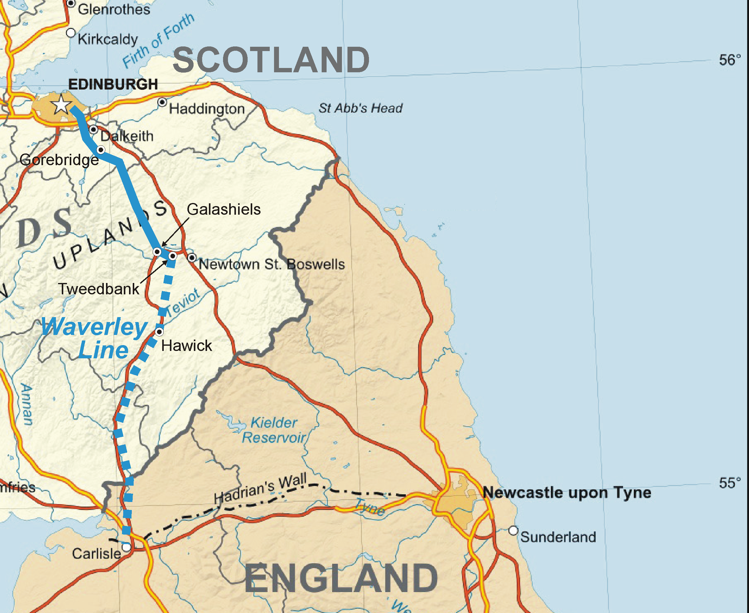
English: Map of the en:Waverley Line in Scotland, partly under construction as of 2011, partly closed. |
| Dagur | (UTC) |
| Kelda | |
| Høvundur |
|
I, the copyright holder of this work, hereby publish it under the following licenses:
This file is licensed under the Creative Commons Attribution-Share Alike 3.0 Unported, 2.5 Generic, 2.0 Generic and 1.0 Generic license.
- Tú ert vælkomin til:
- at deila – at avrita, breiða út og senda verkið
- at remiksa – at tillaga ella broyta verkið
- Undir hesum treytum:
- ognan – Tú mást ognarskrivað verkið á ein slíkan hátt sum er útgreinaður av høvundanum ella lisenseigaranum (men ikki á nakran hátt ið kundi bent á at hesin hevur góðkent teg ella tína nýtslu av verkinum).
- deil undir somu treytum – Um tú broytir, evnar til ella byggir víðari á hetta verk, so kanst tú bert útgeva verkið undir somu ella líkandi lisensi sum hesin.

|
Loyvi verður givi at avrita, bera út og/ella broyta hetta skjal undir treytunum hjá GNU Free Documentation License, versión 1.2 ella einhvør seinni versjón ið er útgivin av Free Software Foundation; uttan nakað óbroytiligt brot, uttan forsíðutekst og uttan baksíðutekst. Eitt avrit av loyvinum er tikið við í brotinum ið nevnist GNU Free Documentation License.http://www.gnu.org/copyleft/fdl.htmlGFDLGNU Free Documentation Licensetruetrue |
Tú kanst velja tann lisens ið tú ynskir.
Original upload log
This image is a derivative work of the following images:
- File:Scotland_map-en.jpg licensed with Cc-by-sa-3.0,2.5,2.0,1.0, GFDL
- 2010-07-17T21:37:14Z Sting 2400x3450 (2273674 Bytes) Color profile
- 2008-06-17T22:28:20Z Sting 2400x3450 (2188752 Bytes) Colors modified
- 2007-12-14T01:24:15Z Sting 2400x3450 (2326842 Bytes) Additional name
- 2007-12-13T19:53:38Z Sting 2400x3450 (2322796 Bytes) {{Location|57|00|00|N|04|00|00|W|scale:4000000}} {{Information |Description=Map in English of [[:en:Scotland|Scotland]]This is a lighter raster JPG format version of [[:Image:Scotland_map-en.svg]] which should be used in the
Also used File:Ordnance_Survey_1-250000_-_NT.jpg.
Uploaded with derivativeFX
Captions
Add a one-line explanation of what this file represents
Items portrayed in this file
depicts enskt
copyright status enskt
copyrighted enskt
copyright license enskt
7. sep 2011
media type enskt
image/png
Søgan hjá fíluni
Trýst á dato/tíð fyri at síggja fíluna, sum hon sá út tá.
| Dagur/Tíð | Lítil mynd | Dimensjónir | Brúkari | Viðmerking | |
|---|---|---|---|---|---|
| streymur | 7. sep 2011 kl. 13:05 | | 2.438 × 1.993 (3,08 MB) | Classical geographer | {{Information |Description={{en|Map of the Waverley Line in Scotland, partly under construction as of 2011, partly closed.}} |Source=*File:Scotland_map-en.jpg |Date=2011-09-07 13:04 (UTC) |Author=*File:Scotland_map-en.jpg: Eric Gaba ([[Us |
Myndarslóðir
Ongar síður slóða til hesa myndina.
Alheims fílunýtsla
Aðrar wkiir brúka hesa fílu:
- Nýtsla á en.wikipedia.org
Heintað frá "https://fo.wikipedia.org/wiki/Mynd:Waverley_Line.png"