File:East-Hem_476ad.jpg
From Wikipedia, the free encyclopedia
Alkuperäinen tiedosto (3 240 × 1 903 kuvapistettä, 754 KiB, MIME-tyyppi: image/jpeg)
| Tämä tiedosto on tiedostotietokanta Wikimedia Commonsista. Tiedot kuvaussivulta näkyvät alla. |  |
Tiedoston kuvaussivu Commonsissa |

|
Tämä tyyppiä historical map oleva kuva pitäisi luoda uudelleen SVG-tiedostoksi vektorigrafiikan avulla. Tällä tiedostotyypillä on monia vahvuuksia, sivulta Commons:Media for cleanup löytyy lisätietoja. Jos tästä kuvasta on jo olemassa SVG-versio, ole ystävällinen ja tallenna se tänne. SVG-tiedoston tallentamisen jälkeen vaihda tämä malline mallineeseen {{vector version available|uusi kuvan nimi.svg}}.
|
 | Tämä tiedosto tai kaikki tässä luokassa sijaitsevat tiedostot on ladattu Commonsiin JPEG-tiedostomuodolla. Kuitenkin tämä kuva sisältää tai tämän luokan tiedostot sisältävät tietoja, jotka voisi esittää tehokkaammin PNG- tai SVG-muodossa. Jos mahdollista, etsi käsiisi kuvan pakkaamaton versio ja lähetä se uudestaan jommassakummassa mainituista muodoista. Tällöin kuvaan ei tule mukaan pakkausartefakteja. Kun olet tehnyt sen, korvaa kaikki kuvan JPEG-version käytöt sopivalla kuvalla ja merkitse tämä kuva mallineella {{Superseded|Uuden kuvan nimi|Bad JPEG}}. |  |
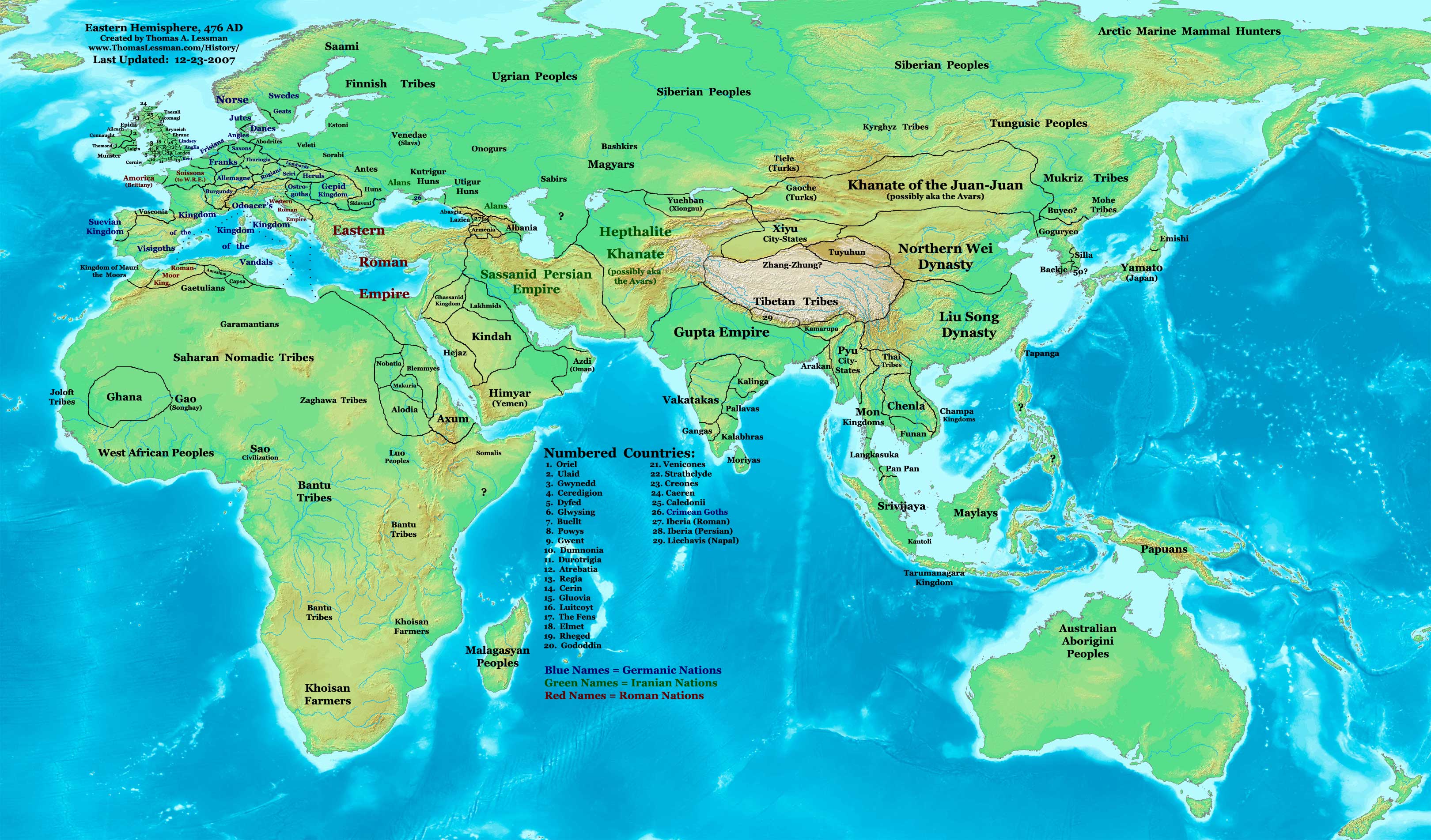
| KuvausEast-Hem 476ad.jpg | Eastern Hemisphere in 476 AD. | |||
| Lähde | self-made (For reference information, see the Map Source References section below.) | |||
| Tekijä | Thomas Lessman (Contact!) | |||
| Käyttöoikeus (Tämän tiedoston uudelleenkäyttö) |
Minä, tämän teoksen tekijänoikeuksien haltija, julkaisen täten tämän teoksen seuraavalla lisenssillä: Tämä tiedosto on lisensoitu Creative Commons Nimeä-JaaSamoin 3.0 Ei sovitettu -lisenssillä.
|
|||
| Muut versiot |
|
.jpg)
Sisällys
Map Summary
Original Source URL: http://www.thomaslessman.com/History/images/East-Hem_476ad.jpg.
This map of the Eastern Hemisphere in 476 AD was created by Thomas Lessman, based on information from the sources listed below. This map is free for educational use (see Permission info above). When using this map, please mention that it is available for free at www.WorldHistoryMaps.info.
Map Source References
- Remember, sources often conflict with each other. This map is only as accurate as the information that is available to me. To report any errors or to help further this work, please click here, or email Thomas Lessman at talessman@yis.us
References for information contained in this map:
1. The DK Atlas of World History, 2000 Edition; map of The World in 500 CE, (Pages 50-51) was used for information on several borders in this map.
2. Borders of Europe are mostly derived from the Euratlas.com map of Europe in 500 AD.
- a - Borders of Britain are derived from the "EarlyBritishKingdoms.com", map of map Britain in 475 AD.
3. Borders of Asia are derived mostly from the following sources:
- a - various Wikipedia articles and Google history map searches.
- (More info will be added soon)
4. Some information is derived from Wikimedia's map of The world in 500 CE, created by User:Javierfv1212.
5. Much of the information in this map was cross-checked with Bruce Gordon's Regnal Chronologies.
Other Historical Maps by Thomas Lessman
| Maps of the eastern hemisphere showing history
Bold dates are available on Wikimedia or Wikipedia. | ||
| Primeval | ||
| Ancient
|
·| 600 BC | 550 BC | 527 BC | 500 BC |
400 BC | ·| 1 AD | 50 AD | 100 AD | 200 AD | 300 AD | | |
| Medieval |
·| 500 AD | 565 AD | 600 AD | 700 AD | | |
| Modern |
·| 1500 AD | · * For historical maps of the whole world, | |
| history links talk edit view | ||
Alkuperäinen tallennusloki
- 2007-12-23 11:36 Talessman 3240×1903×8 (771644 bytes) Added numbered legend. Added more info for Manchuria, central Asia, Indonesia, Africa, and British Isles.
- 2007-11-06 22:07 Talessman 3240×1903×8 (718060 bytes) Updated borders for Sudan and Arabia.
- 2007-10-30 00:25 Talessman 3240×1903×8 (718905 bytes) Updated info on far eastern islands, Japan, Indonesia, etc.
- 2007-09-26 15:42 Talessman 2880×1692×8 (572882 bytes) Author: Thomas A. Lessman. Source URL: http://www.ThomasLessman.com/History/images/East-Hem_476ad.jpg. Image was created by me (Thomas Lessman) based on historical information located on Wikipedia, as well as information from maps located in Wikipedia and
- 2007-09-12 21:08 Talessman 2942×1728×8 (578540 bytes) Reverted to version as of 20:43, 12 September 2007
- 2007-09-12 20:44 Talessman 2942×1728×8 (578540 bytes) Reverted to version as of 19:32, 12 September 2007
- 2007-09-12 20:43 Talessman 2942×1728×8 (578540 bytes) Author: Thomas A. Lessman. Source URL: http://www.ThomasLessman.com/History/images/East-Hem_476ad.jpg. Image was created by me (Thomas Lessman) based on historical information located on Wikipedia, as well as information from maps located in Wikipedia and
- 2007-09-12 19:32 Talessman 2942×1728×8 (578540 bytes) Author: Thomas A. Lessman. Source URL: http://www.ThomasLessman.com/History/images/East-Hem_476ad.jpg. Image was created by me (Thomas Lessman) based on historical information located on Wikipedia, as well as information from maps located in Wikipedia and
- 2007-08-23 19:15 Talessman 1973×1159×8 (2352602 bytes) Reverted to earlier revision
- 2007-08-23 19:15 Talessman 1973×1159×8 (2373060 bytes) Author: Thomas A. Lessman. Source URL: http://www.ThomasLessman.com/History/images/East-Hem_600ad.jpg. Image was created by me (Thomas Lessman) based on historical information located on Wikipedia, as well as information from maps located in Wikipedia and
- 2007-08-23 19:12 Talessman 1973×1159×8 (2373060 bytes) Author: Thomas A. Lessman. Source URL: http://www.ThomasLessman.com/History/images/East-Hem_600ad.jpg. Image was created by me (Thomas Lessman) based on historical information located on Wikipedia, as well as information from maps located in Wikipedia and
- 2007-07-21 20:15 Talessman 1973×1159×8 (2352602 bytes) Author: Thomas A. Lessman. Source URL: http://www.ThomasLessman.com/History/images/East-Hem_476ad.jpg. Image was created by me (Thomas Lessman) based on historical information located on Wikipedia, as well as information from maps located in Wikipedia and
Kuvatekstit
Kohteet, joita tässä tiedostossa esitetään
esittää
Tiedoston historia
Päiväystä napsauttamalla näet, millainen tiedosto oli kyseisellä hetkellä.
| Päiväys | Pienoiskuva | Koko | Käyttäjä | Kommentti | |
|---|---|---|---|---|---|
| nykyinen | 18. huhtikuuta 2008 kello 17.32 | | 3 240 × 1 903 (754 KiB) | Rottweiler | {{Information |Description=== Summary == Author: Thomas A. Lessman. Source URL: http://www.ThomasLessman.com/History/images/East-Hem_476ad.jpg. Image was created by Thomas Lessman based on historical information located in sources listed below. This map i |
Tiedoston käyttö
Tätä tiedostoa ei käytetä millään sivulla.
Tiedoston järjestelmänlaajuinen käyttö
Seuraavat muut wikit käyttävät tätä tiedostoa:
- Käyttö sivustolla de.wikipedia.org
- Käyttö sivustolla en.wikipedia.org
- Käyttö sivustolla id.wikipedia.org
- Käyttö sivustolla jv.wikipedia.org
- Käyttö sivustolla rue.wikipedia.org
- Käyttö sivustolla ru.wikipedia.org
- Käyttö sivustolla sv.wikipedia.org
Metatieto
Tämä tiedosto sisältää esimerkiksi kuvanlukijan, digikameran tai kuvankäsittelyohjelman lisäämiä lisätietoja. Kaikki tiedot eivät enää välttämättä vastaa todellisuutta, jos kuvaa on muokattu sen alkuperäisen luonnin jälkeen.
| _error | 0 |
|---|