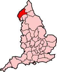
کامبرلند
From Wikipedia, the free encyclopedia
کامبرلند (به انگلیسی: Cumberland) یک شهرستان تاریخی در شمال غربی انگلستان است که جمعیت آن در سرشماری سال ۲۰۱۰ میلادی، ۲۰٬۸۵۹ نفر بودهاست.[1]
| Cumberland | |
|---|---|
 Flag | |
 Ancient extent of Cumberland Ancient extent of Cumberland | |
| مساحت | |
| • ۱۸۳۱ | ۹۶۹٬۴۹۰ جریب فرنگی (۳٬۹۲۳٫۴ کیلومتر مربع)1831 Census cited in &u_id=10001043&show=DB&min_c=1&max_c=5 Vision of Britain] – Ancient county data |
| • ۱۹۱۱ | ۹۷۳٬۰۸۶ جریب فرنگی (۳٬۹۳۷٫۹۴ کیلومتر مربع) |
| • ۱۹۶۱ | ۹۷۳٬۱۴۶ جریب فرنگی (۳٬۹۳۸٫۱۸ کیلومتر مربع) |
| جمعیت | |
| • ۱۹۱۱ | 265,746Vision of Britain – Cumberland population (density and area) |
| • ۱۹۶۱ | ۲۹۴٬۳۰۳ |
| تراکم | |
| • ۱۹۱۱ | 0.27/acre |
| • ۱۹۶۱ | 0.3/acre |
| تاریخچه | |
| • Origin | Historic |
| ساخت | 12th Century |
| منسوخشدن | ۱۹۷۴ |
| جایگزین | کامبریا |
| وضعیت | Administrative county (1889–1974)Ceremonial county (until 1974) |
| Chapman code | CUL |
| Government | Cumberland County Council (1889–1974) |
| • HQ | Carlisle |
 Arms of Cumberland County Council Arms of Cumberland County Council | |
| Subdivisions | |
| • Type | Wards (ancient) |
منابع
Wikiwand in your browser!
Seamless Wikipedia browsing. On steroids.
Every time you click a link to Wikipedia, Wiktionary or Wikiquote in your browser's search results, it will show the modern Wikiwand interface.
Wikiwand extension is a five stars, simple, with minimum permission required to keep your browsing private, safe and transparent.
