File:Spitsbergen_labelled.png
From Wikipedia, the free encyclopedia
Spitsbergen_labelled.png (۴۵۱ × ۴۴۶ پیکسل، اندازهٔ پرونده: ۱۶۱ کیلوبایت، نوع MIME پرونده: image/png)
این پرونده در ویکیانبار موجود است. محتویات صفحهٔ توصیف آن در زیر نمایش داده میشود. |
خلاصه
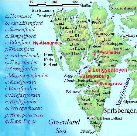
| توضیحSpitsbergen labelled.png |
English: Map detailing the marine features of Spitsbergen in the Svalbard archipelago. Settlements and mountains are indicated and labelled. See also Image:Spitsbergen mountains and marine features labelled.png. Locations were labelled mainly based on detailed maps from svalbard-images.com (sample of south Spitsbergen linked), cross-referenced with other map sources where possible. Norwegian Polar Institute figures were used for mountain names and heights, which are given in meters above sea level. |
| تاریخ | ۲۵ ژوئیه ۲۰۰۶ (تاریخ اصلی بارگذاری) |
| منبع | No machine-readable source provided. Own work assumed (based on copyright claims). |
| پدیدآور | No machine-readable author provided. TheGrappler assumed (based on copyright claims). |
اجازهنامه
DEMIS World Map Server archive copy at the Wayback Machine generated this map from Public Domain sources. DEMIS does not claim any rights over the resultant image ([1] archive copy at the Wayback Machine). Alterations, including the addition of settlements and captions, were performed on 24 July 2006 by User:TheGrappler, the uploader, who releases all associated rights.
| Public domainPublic domainfalsefalse |
| من، دارنده حق تکثیر این اثر، این اثر را به مالکیت عمومی منتشر میکنم. این قابل اجرا در تمام نقاط جهان است. در برخی از کشورها ممکن است به صورت قانونی این امکانپذیر نباشد؛ اگر چنین است: من اجازهٔ استفاده از این اثر را برای هر مقصودی، بدون هیچگونه شرایطی میدهم، تا وقتی که این شرایط توسط قانون مستلزم نشده باشد. |
| Public domainPublic domainfalsefalse |
This image is in the public domain because it came from the site https://www.demis.nl/products/web-map-server/examples/ and was released by the copyright holder. Permission is granted to copy, distribute and/or modify this map since it is based on free of copyright images from: www.demis.nl. See also approval email on de.wp and its clarification.
Deutsch | English | македонски | മലയാളം | Nederlands | slovenščina | +/− |
| Public domainPublic domainfalsefalse |
| This work has been released into the public domain by its copyright holder, www.demis.nl. This applies worldwide. در برخی از کشورها ممکن است به صورت قانونی این امکانپذیر نباشد؛ اگر چنین است: www.demis.nl به هر کسی اجازهٔ استفاده از این اثر برای هر مقصودی، بدون هیچگونه شرایطی، را میدهد تا وقتی که این شرایط توسط قانون مستلزم نشده باشند. Public domainPublic domainfalsefalse |
عنوان
آیتمهایی که در این پرونده نمایش داده شدهاند
توصیفها
۲۵ ژوئیهٔ 2006
تاریخچهٔ پرونده
روی تاریخ/زمانها کلیک کنید تا نسخهٔ مربوط به آن هنگام را ببینید.
| تاریخ/زمان | بندانگشتی | ابعاد | کاربر | توضیح | |
|---|---|---|---|---|---|
| کنونی | ۲۶ ژوئیهٔ ۲۰۰۶، ساعت ۰۹:۲۳ | | ۴۵۱ در ۴۴۶ (۱۶۱ کیلوبایت) | TheGrappler | More detail in South |
| ۲۵ ژوئیهٔ ۲۰۰۶، ساعت ۰۰:۵۸ |  | ۴۵۱ در ۴۴۶ (۱۵۹ کیلوبایت) | TheGrappler | Move "Albert I Land" label slightly, to avoid obscuring Magdalenefjorden | |
| ۲۵ ژوئیهٔ ۲۰۰۶، ساعت ۰۰:۴۶ |  | ۴۵۱ در ۴۴۶ (۱۶۰ کیلوبایت) | TheGrappler | == Summary == {{English}} Map detailing the marine features of Spitsbergen in the Svalbard archipelago. Settlements and mountains are indicated and labelled. See also Image:Spitsbergen mountains and marine features labelled.png. Locations were labell |
کاربرد پرونده
صفحههای زیر از این تصویر استفاده میکنند:
کاربرد سراسری پرونده
ویکیهای دیگر زیر از این پرونده استفاده میکنند:
- کاربرد در af.wikipedia.org
- کاربرد در ast.wikipedia.org
- کاربرد در az.wikipedia.org
- کاربرد در bg.wikipedia.org
- کاربرد در ca.wikipedia.org
- کاربرد در cv.wikipedia.org
- کاربرد در da.wikipedia.org
- کاربرد در de.wikipedia.org
- کاربرد در el.wikipedia.org
- کاربرد در en.wikipedia.org
- Spitsbergen
- Danes Island
- Isfjorden (Svalbard)
- Wijdefjorden
- Van Mijenfjorden
- Olav V Land
- Fairhaven (Svalbard)
- Bellsund
- Magdalenefjorden
- Recherche Fjord
- Forlandsundet
- Engelskbukta
- Amsterdam Island (Spitsbergen)
- Van Muydenbukta
- Van Keulenfjorden
- Krossfjorden
- Billefjorden
- Adventfjorden
- Grønfjorden
- Ekmanfjorden
- Moffen
- Sørkappøya
نمایش استفادههای سراسری از این پرونده.