Fitxategi:Europe_countries_map_contours.png
From Wikipedia, the free encyclopedia

Aurreikuspen honen neurria: 737 × 600 pixel. Bestelako bereizmenak: 295 × 240 pixel | 590 × 480 pixel | 944 × 768 pixel | 1.259 × 1.024 pixel | 1.475 × 1.200 pixel.
Bereizmen handikoa ((1.475 × 1.200 pixel, fitxategiaren tamaina: 106 KB, MIME mota: image/png))
Fitxategi hau Wikimedia Commonsekoa da. Hango deskribapen orriko informazioa behean duzu. |
| DeskribapenaEurope countries map contours.png |
English: Map with the the outlines of countries in Europe and related international vehicle registration codes. For further editing, see 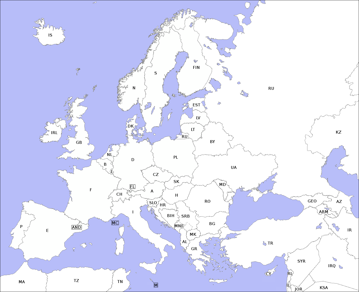 Deutsch: Karte mit Umrissen der europäischen Länder und dem jeweiligen KFZ-Kürzel. Für weiteres Arbeiten an der Datei siehe |
| Data | (UTC) |
| Jatorria | |
| Egilea |
|
| This is a retouched picture, which means that it has been digitally altered from its original version. The original can be viewed here: Europe countries map contours.xcf:
|
Nik, lan honen egileak, argitaratzen dut ondorengo lizentzia hauen pean:
| Fitxategi hau Creative Commons Attribution-Share Alike 3.0 Unported lizentziapean dago. | ||
| ||
| This licensing tag was added to this file as part of the GFDL licensing update.http://creativecommons.org/licenses/by-sa/3.0/CC BY-SA 3.0Creative Commons Attribution-Share Alike 3.0truetrue |

|
Baimena duzu dokumentu hau kopiatu, banatu edo/eta aldatzeko GNU Free Documentation License baldintzapean, Free Software Foundationek argitaratutako 1.2 edo ondorengo bertsioan; sekzio aldaezinik gabe, azaleko testurik gabe, eta atzeko azaleko testurik gabe. Lizentziaren kopia dago GNU Free Documentation License izenburudun atalean.http://www.gnu.org/copyleft/fdl.htmlGFDLGNU Free Documentation Licensetruetrue |
Nahiago duzun lizentzia erabil dezakezu.
The map has been created with the Generic Mapping Tools: https://www.generic-mapping-tools.org/ using one or more of these public-domain datasets for the relief:
বাংলা ∙ English ∙ español ∙ français ∙ italiano ∙ 日本語 ∙ македонски ∙ sicilianu ∙ 中文(简体) ∙ 中文(繁體) ∙ +/− |
|
|
Baimena duzu dokumentu hau kopiatu, banatu edo/eta aldatzeko GNU Free Documentation License baldintzapean, Free Software Foundationek argitaratutako 1.2 edo ondorengo bertsioan; sekzio aldaezinik gabe, azaleko testurik gabe, eta atzeko azaleko testurik gabe. Lizentziaren kopia dago GNU Free Documentation License izenburudun atalean.http://www.gnu.org/copyleft/fdl.htmlGFDLGNU Free Documentation Licensetruetrue |
Jatorrizko igoera erregistroa
This image is a derivative work of the following images:
- File:Europe_countries_map_contours.xcf licensed with Cc-by-sa-3.0-migrated, GFDL-GMT
- 2011-03-12T14:23:23Z Malenki 0x0 (448500 Bytes) {{Information |Description={{en|Map with the the outlines of countries in Europe and related international vehicle registration codes.}}{{de|Karte mit Umrissen der europäischen Länder und dem jeweiligen KFZ-Kürzel.}} |Sour
Uploaded with derivativeFX
Irudi-oineko testuak
Add a one-line explanation of what this file represents
Fitxategi honetan agertzen diren itemak
honako hau irudikatzen du
12 martxoa 2011
Fitxategiaren historia
Data/orduan klik egin fitxategiak orduan zuen itxura ikusteko.
| Data/Ordua | Iruditxoa | Neurriak | Erabiltzailea | Iruzkina | |
|---|---|---|---|---|---|
| oraingoa | 16:31, 12 martxoa 2011 | | 1.475 × 1.200 (106 KB) | Malenki | {{Information |Description={{en|Map with the the outlines of countries in Europe and related international vehicle registration codes. For further editing, see File:Europe_countries_map_contours.xcf}}{{de|Karte mit Umrissen der europäischen Länder u |
Irudira dakarten loturak
Ez dago fitxategi hau darabilen orririk.
Fitxategiaren erabilera orokorra
Hurrengo beste wikiek fitxategi hau darabilte:
- incubator.wikimedia.org proiektuan duen erabilera
"https://eu.wikipedia.org/wiki/Fitxategi:Europe_countries_map_contours.png"(e)tik eskuratuta