File:East-Hem_1000bc.jpg
From Wikipedia, the free encyclopedia
- Fitxategia
- Fitxategiaren historia
- Irudira dakarten loturak
- Fitxategiaren erabilera orokorra
- Metadatuak
Bereizmen handikoa ((3.240 × 1.903 pixel, fitxategiaren tamaina: 1,43 MB, MIME mota: image/jpeg))
Fitxategi hau Wikimedia Commonsekoa da. Hango deskribapen orriko informazioa behean duzu. |

|
Irudi hau birsortu beharko litzateke SVG irudi bektorial moduan. Honek abantaila asko ematen ditu, ikus Commons:Media for cleanup (ingelesez) informazio gehiagorako. Irudi honen SVG bertsioa eskuragarri badago, mesedez Commonsera igo. Igo ostean, ordezkatu txantiloi hau txantiloi honegatik {{vector version available|irudiaren izen berria.svg}} irudi honetan.
|
 | This historical map image was uploaded in the JPEG format even though it consists of non-photographic data. This information could be stored more efficiently or accurately in the PNG or SVG format. If possible, please upload a PNG or SVG version of this image without compression artifacts, derived from a non-JPEG source (or with existing artifacts removed). After doing so, please tag the JPEG version with {{Superseded|NewImage.ext}} and remove this tag. This tag should not be applied to photographs or scans. If this image is a diagram or other image suitable for vectorisation, please tag this image with {{Convert to SVG}} instead of {{BadJPEG}}. If not suitable for vectorisation, use {{Convert to PNG}}. For more information, see {{BadJPEG}}. |  |
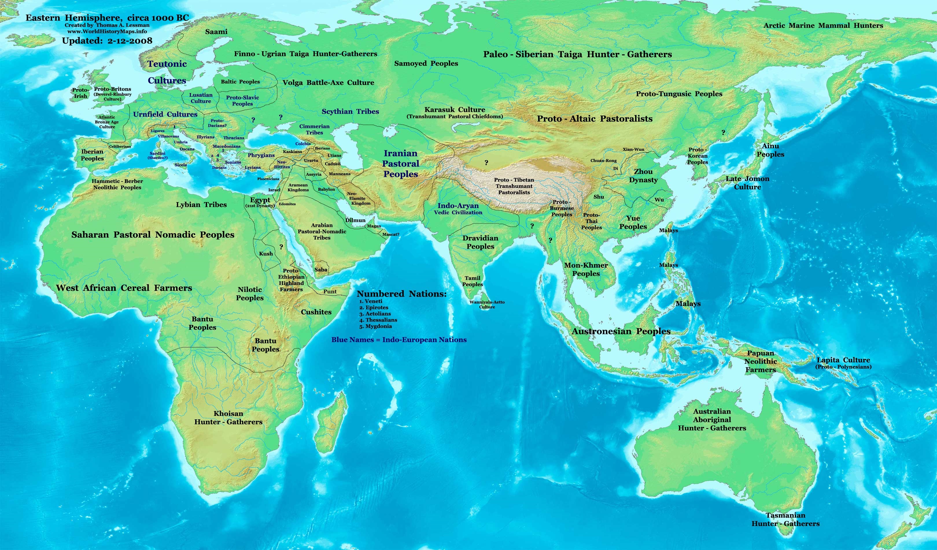
| DeskribapenaEast-Hem 1000bc.jpg | Eastern Hemisphere in 1000 BC. |
| Jatorria | self-made (For reference information, see below) |
| Egilea | Thomas Lessman (Contact!) |
| Beste bertsioak | see East-Hem_1000bc.jpg file history on Wikipedia. |
Lizentzia
- Askea zara:
- partekatzeko – lana kopiatzeko, banatzeko eta bidaltzeko
- birnahasteko – lana moldatzeko
- Ondorengo baldintzen pean:
- eskuduntza – Egiletza behar bezala aitortu behar duzu, lizentzia ikusteko esteka gehitu, eta ea aldaketak egin diren aipatu. Era egokian egin behar duzu hori guztia, baina inola ere ez egileak zure lana edo zure erabilera babesten duela irudikatuz.
- berdin partekatu – Lan honetan oinarrituta edo aldatuta berria eraikitzen baduzu, emaitza lana hau bezalako lizentzia batekin argitaratu behar duzu.
Map Summary
Original Source URL: http://www.thomaslessman.com/History/images/East-Hem_1000bc.jpg.
This map of the Eastern Hemisphere in 1000 BC was created by Thomas Lessman, based on information from the sources listed below. This map is free for educational use (see Permission info above). When using this map, please mention that it is available for free at www.WorldHistoryMaps.info.
Map Source References
- Remember, sources often conflict with each other. This map is only as accurate as the information that is available to me. To report any errors or to help further this work, please click here, or email Thomas Lessman at talessman@yis.us
References for information contained in this map:
1. Some info derive from the map of the World 1000 BCE, created by User:Briangotts..
2. Zhou (China) borders derive partially from the Huhai.net map of China: 11th to 9th centuries BC.
3. Some information derives from DK Atlas of World History, 2000 edition.
4. Other information is based on various Wikipedia articles and google searches dealing with nations depicted in this map.
Other Maps by Thomas Lessman
| Maps of the eastern hemisphere showing history
Bold dates are available on Wikimedia or Wikipedia. | ||
| Primeval | ||
| Ancient
|
·| 600 BC | 550 BC | 527 BC | 500 BC |
400 BC | ·| 1 AD | 50 AD | 100 AD | 200 AD | 300 AD | | |
| Medieval |
·| 500 AD | 565 AD | 600 AD | 700 AD | | |
| Modern |
·| 1500 AD | · * For historical maps of the whole world, | |
| history links talk edit view | ||
| Annotations InfoField | This image is annotated: View the annotations at Commons |


Irudi-oineko testuak
Fitxategi honetan agertzen diren itemak
honako hau irudikatzen du
some value
Fitxategiaren historia
Data/orduan klik egin fitxategiak orduan zuen itxura ikusteko.
| Data/Ordua | Iruditxoa | Neurriak | Erabiltzailea | Iruzkina | |
|---|---|---|---|---|---|
| oraingoa | 13:13, 28 iraila 2023 | | 3.240 × 1.903 (1,43 MB) | Notradeuussrs | added Punt |
| 09:15, 9 maiatza 2008 |  | 3.240 × 1.903 (720 KB) | Talessman | {{Information |Description='''Eastern Hemisphere in 1000 BC'''. |Source=self-made (For reference information, see below) |Author=Thomas Lessman (Contact!) |Date= |Location= |Permission={{self|cc-by-sa-3.0}} |othe |
Irudira dakarten loturak
Ez dago fitxategi hau darabilen orririk.
Fitxategiaren erabilera orokorra
Hurrengo beste wikiek fitxategi hau darabilte:
- ar.wikipedia.org proiektuan duen erabilera
- en.wikipedia.org proiektuan duen erabilera
- Chaldea
- 1st millennium BC
- 2nd millennium BC
- 10th century BC
- 1000s BC (decade)
- Indo-Iranians
- Late Bronze Age collapse
- User:Talessman/Maps
- User talk:Talessman/Maps
- List of political entities in the 10th century BC
- User:Benjamin Trovato/sandbox
- Transjordan (region)
- User:Falcaorib/Ancient East Hemisphere
- fr.wikipedia.org proiektuan duen erabilera
- gl.wikipedia.org proiektuan duen erabilera
- hy.wikipedia.org proiektuan duen erabilera
- hyw.wikipedia.org proiektuan duen erabilera
- ku.wikipedia.org proiektuan duen erabilera
- ro.wikipedia.org proiektuan duen erabilera
- sv.wikipedia.org proiektuan duen erabilera
- tr.wikipedia.org proiektuan duen erabilera
Metadatuak
Fitxategi honek informazio gehigarri dauka, ziurrenik kamera digital edo eskanerrak egiterako momentuan gehitutakoa. Hori dela-eta, jatorrizko fitxategi hori aldatu egin bada, baliteke xehetasun batzuek errealitatearekin bat ez egitea.
| Orientazioa | Arrunta |
|---|