Archivo:North_Dakota_wind_resource_map_50m_800.jpg
De Wikipedia, la enciclopedia encyclopedia
Ver la imagen en su resolución original (1100 × 850 píxeles; tamaño de archivo: 787 kB; tipo MIME: image/jpeg)
|
|
Este es un archivo de Wikimedia Commons, un depósito de contenido libre hospedado por la Fundación Wikimedia. Más abajo se reproduce su página de descripción con la información sobre su origen y licencia. |
Resumen
| DescripciónNorth Dakota wind resource map 50m 800.jpg |
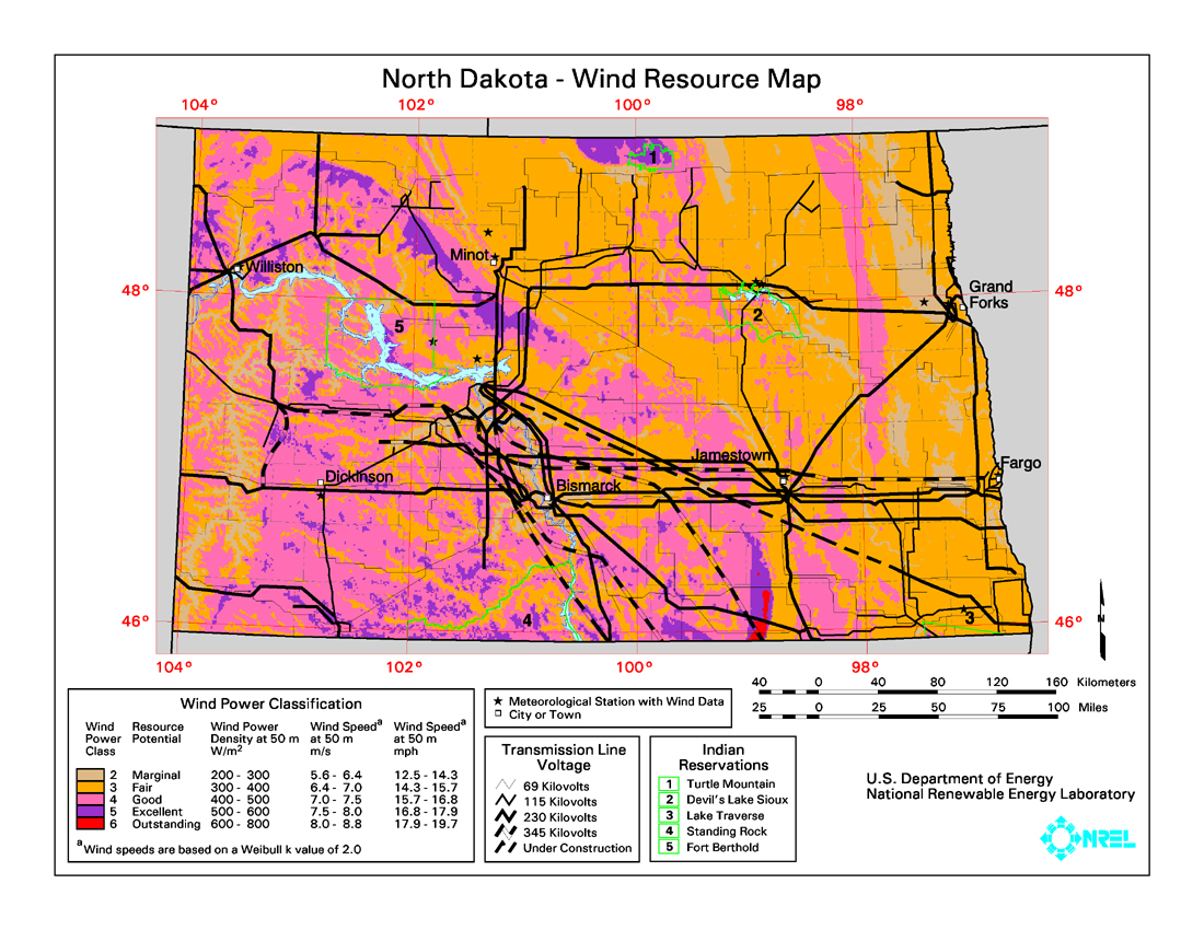
English: Average annual wind power distribution for North Dakota, 50m height above ground, also showing location of existing electrical transmission lines |
| Fecha | not given |
| Fuente | http://www.windpoweringamerica.gov/images/windmaps/nd_50m_800.jpg |
| Autor | United States Department of Energy, National Renewable Energy Laboratory, TrueWind Solutions |
| Permiso (Reutilización de este archivo) |
EERE copyright policy says its works are public domain: http://www1.eere.energy.gov/webpolicies/#copyright |
| Otras versiones | http://www.awstruewind.com/files/ND_pwr50m.pdf - more detailed commercial version |
Licencia
| Public domainPublic domainfalsefalse |
| This image is a work of a United States Department of Energy (or predecessor organization) employee, taken or made as part of that person's official duties. As a work of the U.S. federal government, the image is in the public domain.
Please note that national laboratories operate under varying licences and some are not free. Check the site policies of any national lab before crediting it with this tag. العربية ∙ English ∙ français ∙ 日本語 ∙ македонски ∙ മലയാളം ∙ Nederlands ∙ русский ∙ українська ∙ Tiếng Việt ∙ 简体中文 ∙ 繁體中文 ∙ +/− |

|
Leyendas
Elementos representados en este archivo
representa a
805 923 byte
850 píxel
1100 píxel
image/jpeg
495513aa9e9384879132bb0683fe2956c90392fb
Historial del archivo
Haz clic sobre una fecha y hora para ver el archivo tal como apareció en ese momento.
| Fecha y hora | Miniatura | Dimensiones | Usuario | Comentario | |
|---|---|---|---|---|---|
| actual | 07:55 26 ene 2009 | | 1100 × 850 (787 kB) | Teratornis | == Summary == {{Information |Description={{en|1=Average annual wind power distribution for North Dakota, 50m height above ground, also showing location of existing electrical transmission lines}} |Source=http://www.windpoweringamerica.gov/images/windmaps/ |
Usos del archivo
La siguiente página usa este archivo:
Uso global del archivo
Las wikis siguientes utilizan este archivo:
- Uso en en.wikipedia.org
Metadatos
Este archivo contiene información adicional, probablemente añadida por la cámara digital o el escáner usado para crearlo o digitalizarlo.
Si el archivo ha sido modificado desde su estado original, pueden haberse perdido algunos detalles.
| Orientación | Normal |
|---|---|
| Resolución horizontal | 100 ppp |
| Resolución vertical | 100 ppp |
| Software usado | Adobe Photoshop 7.0 |
| Fecha y hora de modificación del archivo | 17:38 8 jun 2005 |
| Espacio de color | Sin calibrar |