Archivo:Nantucket_NM23-744-635.jpg
De Wikipedia, la enciclopedia encyclopedia
Ver la imagen en su resolución original (4024 × 4024 píxeles; tamaño de archivo: 13,64 MB; tipo MIME: image/jpeg)
|
|
Este es un archivo de Wikimedia Commons, un depósito de contenido libre hospedado por la Fundación Wikimedia. Más abajo se reproduce su página de descripción con la información sobre su origen y licencia. |
Sumario
Resumen
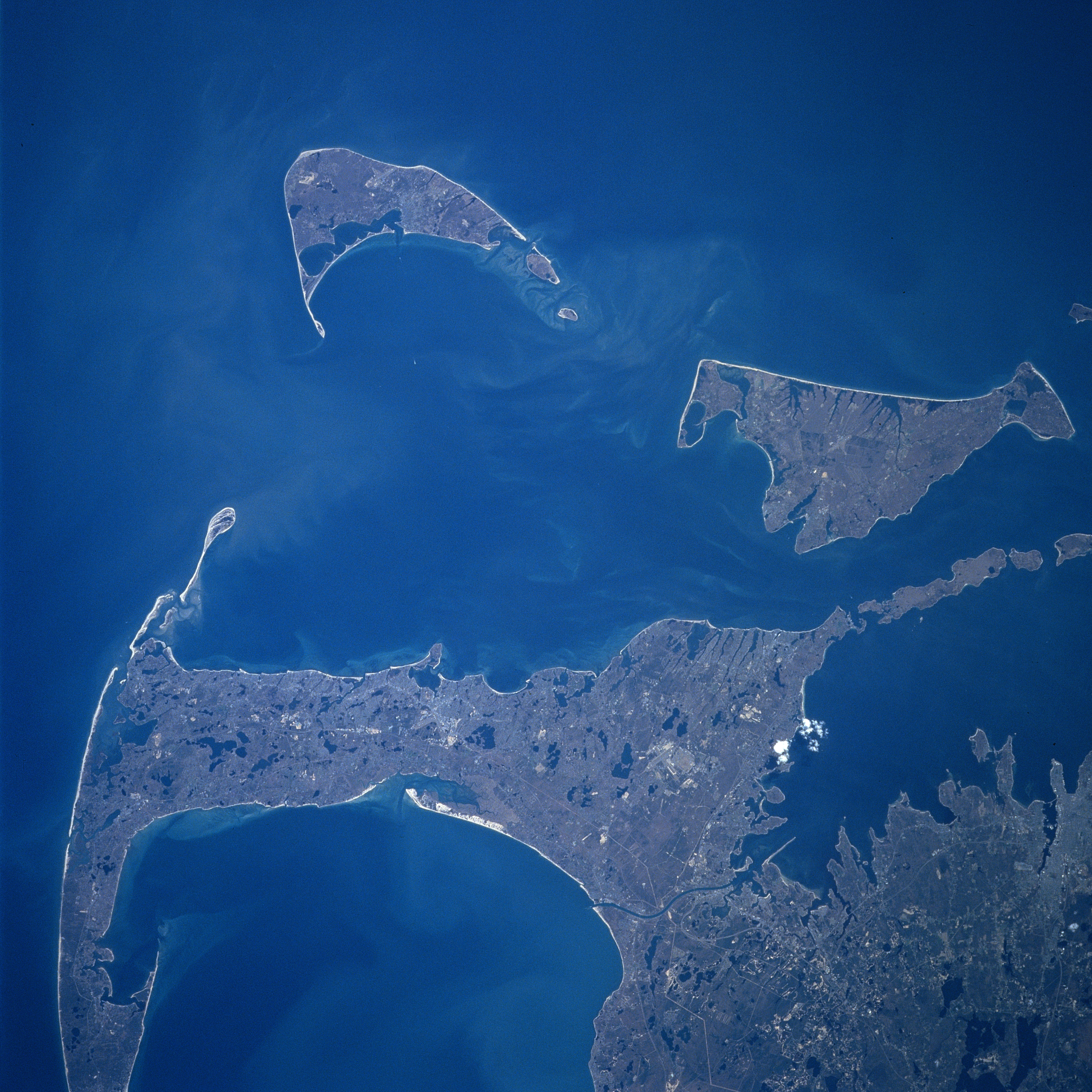
Cape Cod, Nantucket and Marthas Vineyard Islands, Massachusetts Spring 1997
Fonte
Earth.Jonhson Space Center.National Aeronautic and Space Administration.government/Space Shuttle Earth Observations Photography/Earth From Space/low resolution. Nantucket
View from Space Shuttle Atlantis STS84, docking Mir space station, mission NM23-744-635, Launch: April 1997.
Cape Cod, Nantucket and Marthas Vineyard Islands, Massachusetts Spring 1997
Looking generally to the south, Cape Cod and the islands of Nantucket and Marthas Vineyard are visible in this synoptic view. Nantucket Island is located 30 miles (48 km) off the coast of southeast Massachusetts. The island is 14 miles (23 km) long and from 3 to 6 miles (5 to 10 km) wide. Nantucket Island has many sandy beaches and low rolling hills composed of sand and gravel. Marthas Vineyard is the larger of the two islands and is triangular shaped island situated 7 miles (11 km) off the southern coast of Massachusetts. Marthas Vineyard is 23 miles (37 km) wide (east to west) and 9 miles (14 km) long (north to south), and covers 100 sq. miles (259 km2). Both islands are favorite tourist and resort areas. North of Martha's Vineyard (right center), the Elizabeth Islands and Buzzards Bay are visible. Cape Cod Bay is in the lower left portion of the image.
Content Provider
Kamlesh P. Lulla Ph.D. Chief, Earth Sciences Branch
Responsible NASA Official: Ed Wilson
Curator: Jaime Powell
Last Update: 06/17/2002
Licencia
| Public domainPublic domainfalsefalse |
| Este archivo es de dominio público porque fue creado por la NASA. Las políticas sobre copyright de la NASA estipulan que «el material de la NASA no está protegido con copyright a menos que se indique lo contrario». (Políticas sobre copyright de la NASA o Políticas sobre la utilización de imágenes del Jet Propulsion Laboratory). | ||
 |
Advertencias:
|
Leyendas
Elementos representados en este archivo
representa a
image/jpeg
Historial del archivo
Haz clic sobre una fecha y hora para ver el archivo tal como apareció en ese momento.
| Fecha y hora | Miniatura | Dimensiones | Usuario | Comentario | |
|---|---|---|---|---|---|
| actual | 21:24 24 jul 2023 | | 4024 × 4024 (13,64 MB) | Don-vip | |
| 10:15 1 sep 2005 |  | 640 × 640 (39 kB) | Roger469 | == Fonte == Earth.Jonhson Space Center.National Aeronautic and Space Administration.government/Space Shuttle Earth Observations Photography/Earth From Space/low resolution.[ http://earth.jsc.nasa.gov/sseop/efs/lores.pl?PHOTO= NM23-744-635 Nantucket] <br> |
Usos del archivo
La siguiente página usa este archivo:
Uso global del archivo
Las wikis siguientes utilizan este archivo:
- Uso en ceb.wikipedia.org
- Uso en ja.wikipedia.org
- Uso en www.wikidata.org