Archivo:Americas_satellite_map.jpg
De Wikipedia, la enciclopedia encyclopedia
Ver la imagen en su resolución original (2300 × 2900 píxeles; tamaño de archivo: 1,87 MB; tipo MIME: image/jpeg)
|
|
Este es un archivo de Wikimedia Commons, un depósito de contenido libre hospedado por la Fundación Wikimedia. Más abajo se reproduce su página de descripción con la información sobre su origen y licencia. |
Resumen
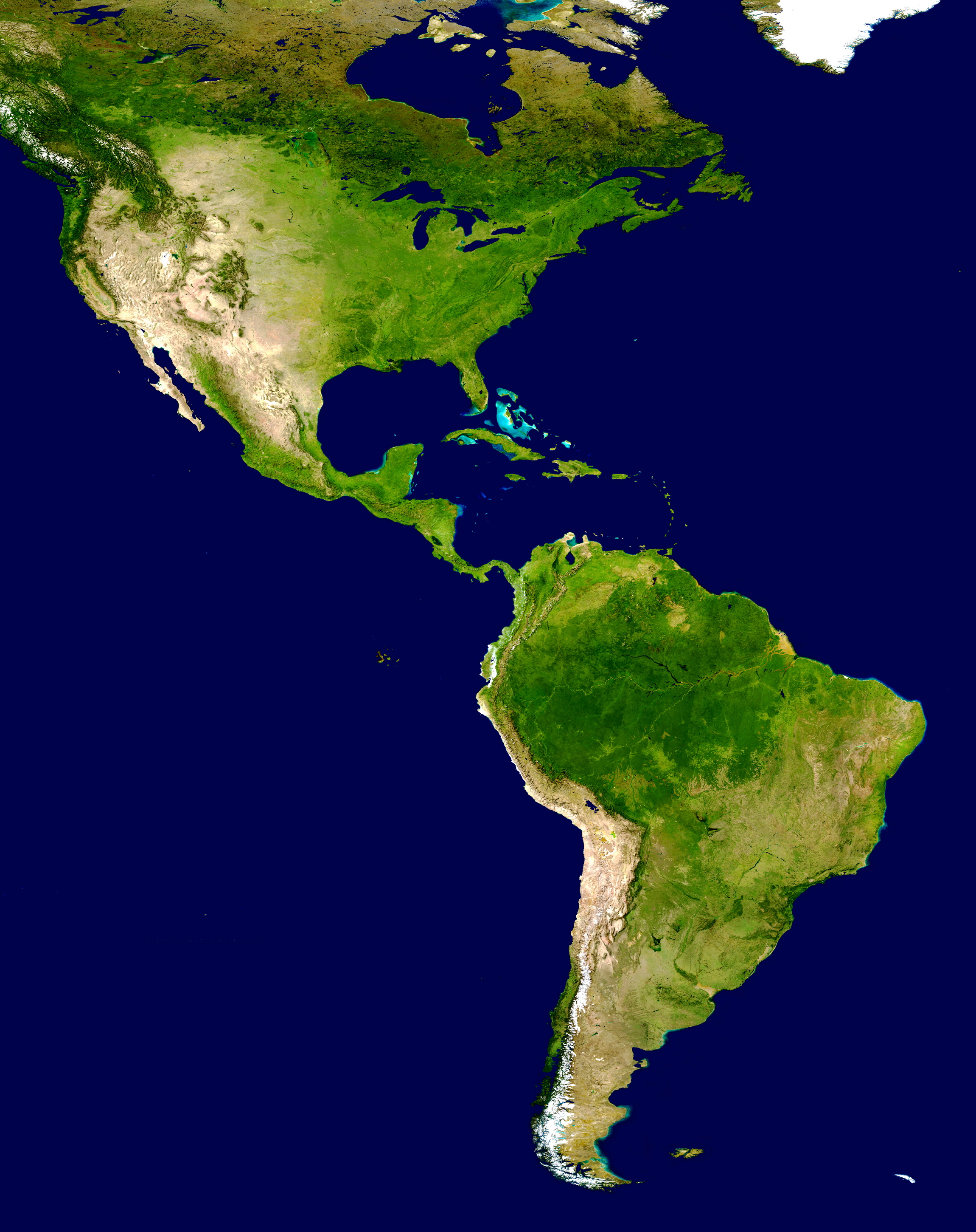
| DescripciónAmericas satellite map.jpg |
NASA's description of the original non-cropped imageː "This spectacular “blue marble” image is the most detailed true-color image of the entire Earth to date. Using a collection of satellite-based observations, scientists and visualizers stitched together months of observations of the land surface, oceans, sea ice, and clouds into a seamless, true-color mosaic of every square kilometer (.386 square mile) of our planet. These images are freely available to educators, scientists, museums, and the public. This record includes preview images and links to full resolution versions up to 21,600 pixels across. Much of the information contained in this image came from a single remote-sensing device-NASA’s Moderate Resolution Imaging Spectroradiometer, or MODIS. Flying over 700 km above the Earth onboard the Terra satellite, MODIS provides an integrated tool for observing a variety of terrestrial, oceanic, and atmospheric features of the Earth. The land and coastal ocean portions of these images are based on surface observations collected from June through September 2001 and combined, or composited, every eight days to compensate for clouds that might block the sensor’s view of the surface on any single day. Two different types of ocean data were used in these images: shallow water true color data, and global ocean color (or chlorophyll) data. Topographic shading is based on the GTOPO 30 elevation dataset compiled by the U.S. Geological Survey’s EROS Data Center. MODIS observations of polar sea ice were combined with observations of Antarctica made by the National Oceanic and Atmospheric Administration’s AVHRR sensor—the Advanced Very High Resolution Radiometer. The cloud image is a composite of two days of imagery collected in visible light wavelengths and a third day of thermal infra-red imagery over the poles. Global city lights, derived from 9 months of observations from the Defense Meteorological Satellite Program, are superimposed on a darkened land surface map." The 8192 x 4096 TIFF NASA global map has been cropped, adjusted in brightness, and converted to JPEG. |
| Fecha | |
| Fuente | http://visibleearth.nasa.gov/view_rec.php?id=2433 |
| Autor | NASA |
| Otras versiones | Obras derivadas de ésta: Distribution of P. peckolti.jpg |
Licencia
| Public domainPublic domainfalsefalse |
| Este archivo es de dominio público porque fue creado por la NASA. Las políticas sobre copyright de la NASA estipulan que «el material de la NASA no está protegido con copyright a menos que se indique lo contrario». (Políticas sobre copyright de la NASA o Políticas sobre la utilización de imágenes del Jet Propulsion Laboratory). | ||
 |
Advertencias:
|
Leyendas
Elementos representados en este archivo
representa a
septiembre 2001
image/jpeg
414401b78c1c95749a0b485b262f063cbfb3be6a
1 958 581 byte
2900 píxel
2300 píxel
Historial del archivo
Haz clic sobre una fecha y hora para ver el archivo tal como apareció en ese momento.
| Fecha y hora | Miniatura | Dimensiones | Usuario | Comentario | |
|---|---|---|---|---|---|
| actual | 17:23 28 jun 2008 | | 2300 × 2900 (1,87 MB) | WolfmanSF | {{Information |Description=This spectacular “blue marble” image is the most detailed true-color image of the entire Earth to date. Using a collection of satellite-based observations, scientists and visualizers stitched together months of observations |
| 19:54 30 dic 2007 |  | 2300 × 2900 (1,93 MB) | WolfmanSF | {{Information |Description=This spectacular “blue marble” image is the most detailed true-color image of the entire Earth to date. Using a collection of satellite-based observations, scientists and visualizers stitched together months of observations |
Usos del archivo
Las siguientes páginas usan este archivo:
- América del Norte
- Colombia
- Comando Sur de Estados Unidos
- Dominica
- Haití
- Policía Nacional de la República Dominicana
- Categoría:Elecciones en América en 1913
- Categoría:Elecciones en América en 1915
- Categoría:Elecciones en América en 1937
- Categoría:Elecciones en América en 1960
- Categoría:Elecciones en América en 1965
- Categoría:Elecciones en América en 1983
- Categoría:Elecciones en América en 1984
- Categoría:Elecciones en América en 1985
- Categoría:Elecciones en América en 1987
- Categoría:Elecciones en América en 1988
- Categoría:Elecciones en América en 1989
- Categoría:Elecciones en América en 1990
- Categoría:Elecciones en América en 1991
- Categoría:Elecciones en América en 1992
- Categoría:Elecciones en América en 1993
- Categoría:Elecciones en América en 1994
- Categoría:Elecciones en América en 1995
- Categoría:Elecciones en América en 1996
- Categoría:Elecciones en América en 1997
- Portal:América
- Portal:Geografía/Titular
- Wikiproyecto:América del Sur/Proyectos hermanos
- Anexo:Imperios americanos
- Anexo:Supercentenarios latinoamericanos
Uso global del archivo
Las wikis siguientes utilizan este archivo:
- Uso en ar.wikipedia.org
- Uso en bn.wikipedia.org
- Uso en ca.wikipedia.org
- Uso en ca.wikiquote.org
- Uso en ckb.wikipedia.org
- Uso en en.wikipedia.org
- Uso en es.wikivoyage.org
- Uso en eu.wikipedia.org
- Uso en fa.wikipedia.org
- Uso en ff.wikipedia.org
- Uso en fi.wikipedia.org
- Uso en fr.wikipedia.org
Ver más uso global de este archivo.
Metadatos
Este archivo contiene información adicional, probablemente añadida por la cámara digital o el escáner usado para crearlo o digitalizarlo.
Si el archivo ha sido modificado desde su estado original, pueden haberse perdido algunos detalles.
| Orientación | Normal |
|---|---|
| Resolución horizontal | 72 ppp |
| Resolución vertical | 72 ppp |
| Software usado | QuickTime 7.5 |
| Fecha y hora de modificación del archivo | 10:02 28 jun 2008 |
| Posicionamientos Y y C | Centrado |
| Versión de Exif | 2.2 |
| Espacio de color | Sin calibrar |
| Comentario de archivo JPEG | AppleMark |