Archivo:Administrative_divisions_of_Germany.svg
De Wikipedia, la enciclopedia encyclopedia

Ver la imagen en su resolución original ((Imagen SVG, nominalmente 1037 × 519 pixels, tamaño de archivo: 929 kB))
|
|
Este es un archivo de Wikimedia Commons, un depósito de contenido libre hospedado por la Fundación Wikimedia. Más abajo se reproduce su página de descripción con la información sobre su origen y licencia. |
Resumen
| DescripciónAdministrative divisions of Germany.svg |
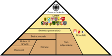
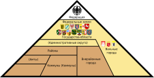
English: Graphic with the administrative division of the Federal Republic of Germany, showing the vertical (Federal) separation of powers across the federal government (White), the states (Yellow), and the municipalities (Brown).
Беларуская: Дыяграма адміністрацыйнага падзелу Федэральнай Рэспублікі Германія, якая адлюстроўвае вертыкальнае (федэральнае) падзяленне ўладаў паміж федэральным урадам (белы), землямі (жоўты) і акругамі (карычневы).
Deutsch: Grafik mit der Verwaltungsgliederung der Bundesrepublik Deutschland. Bundesebene (Weiß), Landesebene (Gelb), Kommunalebene (Braun). Schema des dreistufigen Verwaltungsaufbaus in den Flächenländern. Die allgemeine Verwaltung (1. Stufe) ist braun, die Sonderbehörden (2. und 3. Stufe) sind beige dargestellt.
Italiano: Grafico con la divisione amministrativa della Repubblica Federale di Germania, che mostra la separazione verticale dei poteri nel governo a livello federale (Bianco), degli stati (Giallo) e dei comuni (Marrone). Schema della struttura amministrativa a tre stadi negli stati non urbani. L'amministrazione generale (primo livello) è mostrata in marrone, le autorità speciali (secondo e terzo livello) sono mostrate in giallo.
Español: Gráfico con la división administrativa de la República Federal de Alemania, que muestra la separación vertical de poderes en el gobierno a nivel federal (Blanco), los estados (Amarillo) y los municipios (Marrón). Esquema de la estructura administrativa de tres etapas en los estados no urbanos. La administración general (primer nivel) se muestra en marrón, las autoridades especiales (segundo y tercer nivel) se muestran en amarillo.
Български: Графика на вертикалното административно деление на Федерална република Германия. Федерално ниво (бяло), провинциално ниво (жълто), местно ниво (кафяво). Схема на трите нива на административно устройство в териториалните провинции. Общата администрация (1-то ниво) е изобразено в кафяво, а специалните институции (2-ро и 3-то ниво) в бежаво.
Română: Diagramă cu diviziunea administrativă a Republicii Federale Germania.
Nederlands: Grafiek met de administratieve afdeling van de Bondsrepubliek Duitsland.
Português: Carta com a divisão administrativa da República Federal da Alemanha.
Plattdüütsch: So is de Verwalten in Düütschland vun ünnen na boven upboot.
Українська: Адміністративний устрій Федеративної Республіки Німеччини всіх рівнів
Čeština: Schema administrativního dělení Německa
Русский: Административное устройство Федеративной Республики Германия всех уровней
中文(中国大陆):德国行政区划
العربية: التقسيم الإداري في جمهورية ألمانيا الاتحادية
한국어: 독일 행정구역체계
日本語: ドイツの地方行政
Lëtzebuergesch: Vertikal Verwaltungsstruktur vun Däitschland |
|||
| Fecha | ||||
| Fuente |
Trabajo propio Este archivo deriva de:
|
|||
| Autor | Fred the Oyster (EN), Plaga med (BE), glglgl (original SVG), David Liuzzo (original PNG), C.Löser (content for PNG), Gzhegozh (UK), Roman Poulvas (RU), Poux (FR), JAn Dudík (CS), Soued031 (LB), Trygve W Nodeland (NO), Civvi (IT), R4m.3sp4d4s (ES), Andrew Dalby (LA), Salamander724 (KO), UkainoADX (JA), Nico (DA), Angel Miklashevsky (BG), Aeroid (merged SVG) | |||
| Permiso (Reutilización de este archivo) |
Este archivo se encuentra bajo la licencia Creative Commons Reconocimiento-Compartir bajo la misma licencia 2.0 Alemania.
 |
|||
| Otras versiones |
Imagemaps: To be merged:
|
|||
| SVG desarrollo InfoField | El código fuente de esta imagen SVG es válido. Este mapa fue creado con una desconocida SVG herramienta This map is translated using SVG switch elements: all translations are stored in the same file.
|


.svg)
.svg)
Leyendas
Elementos representados en este archivo
representa a
Algún valor sin elemento de Wikidata
Algún valor sin elemento de Wikidata
6 may 2012
image/svg+xml
fdf0c1b9926b547dbc2d2d520c2e674dc9a6e6e1
1 352 645 byte
519 píxel
1037 píxel
Historial del archivo
Haz clic sobre una fecha y hora para ver el archivo tal como apareció en ese momento.
| Fecha y hora | Miniatura | Dimensiones | Usuario | Comentario | |
|---|---|---|---|---|---|
| actual | 17:50 31 mar 2024 | | 1037 × 519 (929 kB) | Mrmw | cleaned code and prettified switch-block |
| 22:36 5 mar 2024 |  | 1037 × 519 (1,29 MB) | Plaga med | add Belarusian l10n | |
| 16:53 27 may 2022 |  | 1037 × 519 (1,29 MB) | Liglioto | Final, revised translation of administrative terms. | |
| 07:34 27 may 2022 |  | 1037 × 519 (1,29 MB) | Liglioto | Bulgarian translation revised. Administrative terms corrected in accordance with official translations of multilingual EU documents consulted on www.linguee.com | |
| 16:23 25 may 2022 |  | 1037 × 519 (1,29 MB) | Liglioto | Adjusted positions of text fields | |
| 16:05 25 may 2022 |  | 1037 × 519 (1,29 MB) | Liglioto | Translation into Bulgarian | |
| 16:00 25 may 2022 |  | 1037 × 519 (1,29 MB) | Liglioto | Reverted to version as of 17:41, 4 December 2021 (UTC); mismatch of text fields | |
| 15:26 25 may 2022 |  | 1037 × 519 (1,29 MB) | Liglioto | Added translation into Bulgarian language. | |
| 17:41 4 dic 2021 |  | 1037 × 519 (1,29 MB) | Aeroid | SVG 1.1 // Editing SVG source code using c:User:Rillke/SVGedit.js | |
| 17:35 4 dic 2021 |  | 1037 × 519 (1,29 MB) | Aeroid | cleanup warnings // Editing SVG source code using c:User:Rillke/SVGedit.js |
Usos del archivo
Las siguientes páginas usan este archivo:
Uso global del archivo
Las wikis siguientes utilizan este archivo:
- Uso en als.wikipedia.org
- Uso en an.wikipedia.org
- Uso en ar.wikipedia.org
- Uso en ast.wikipedia.org
- Uso en az.wikipedia.org
- Uso en bar.wikipedia.org
- Uso en be.wikipedia.org
- Uso en bg.wikipedia.org
- Uso en bn.wikipedia.org
- Uso en bxr.wikipedia.org
- Uso en cs.wikipedia.org
- Uso en cv.wikipedia.org
- Uso en da.wikipedia.org
- Uso en de.wikipedia.org
- Kreisfreie Stadt
- Gewaltenteilung
- Oberbürgermeister
- Regierungsbezirk
- Stadtstaat
- Kommunalpolitik in Deutschland
- Amt (Kommunalrecht)
- Gemeinde (Deutschland)
- Kommunalrecht (Deutschland)
- Politisches System der Bundesrepublik Deutschland
- Bundesebene (Deutschland)
- Öffentliche Verwaltung
- Föderalismus in Deutschland
- Diskussion:Gemeinde (Deutschland)
- Gemeinde
- Vorkonstitutionelles Recht
- Deutschland
- Benutzer:Gbeckmann
- Verwaltungskooperation in Deutschland
- Verwaltungsgliederung Deutschlands
- Benutzer:Hopfenbart
- Vorlage:Verwaltungsgliederung Deutschlands
Ver más uso global de este archivo.
Metadatos
Este archivo contiene información adicional, probablemente añadida por la cámara digital o el escáner usado para crearlo o digitalizarlo.
Si el archivo ha sido modificado desde su estado original, pueden haberse perdido algunos detalles.
| Anchura | 1037.1 |
|---|---|
| Altura | 518.72 |