Archivo:1814ThompsonMap.jpg
De Wikipedia, la enciclopedia encyclopedia
Ver la imagen en su resolución original (4020 × 2593 píxeles; tamaño de archivo: 3,83 MB; tipo MIME: image/jpeg)
|
|
Este es un archivo de Wikimedia Commons, un depósito de contenido libre hospedado por la Fundación Wikimedia. Más abajo se reproduce su página de descripción con la información sobre su origen y licencia. |
Resumen
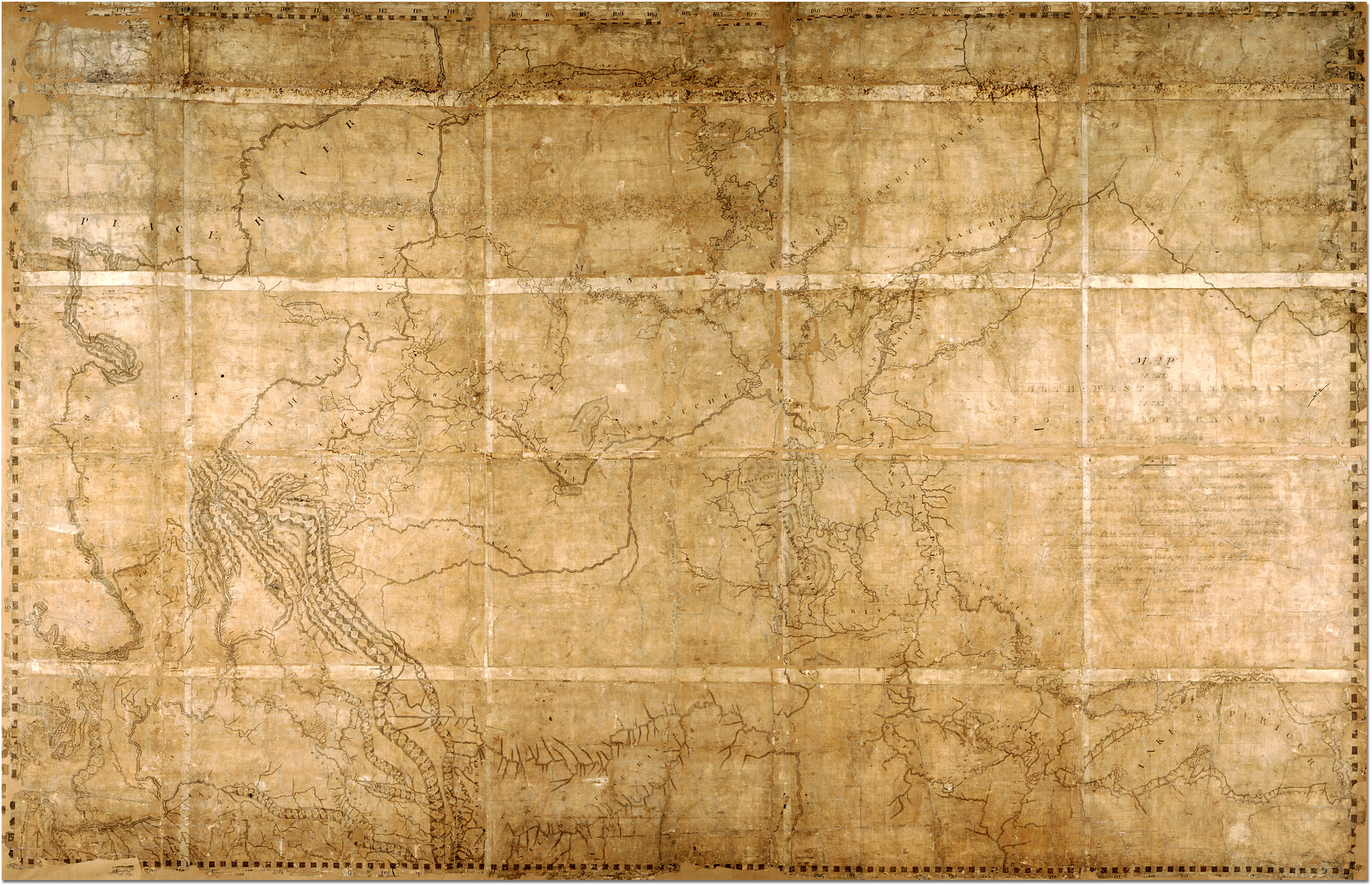
| Descripción1814ThompsonMap.jpg |
English: Map of the North-West Territory of the Province of Canada by David Thompson, 1814 Archives of Ontario, I0012850 Map is in the public domain. See:http://ao.minisisinc.com/scripts/mwimain.dll/144/ARCH_DESC_FACT/FACTSDESC/REFD%2BF%2B443-6?SESSIONSEARCH Full Title: "Map of the North-West Territory of the Province of Canada from actual Survey during the years 1792-1812. This map made for the North West Company in 1813 and 1814 and delivered to the Honorable William McGillivray then agent Embraces the Region lying between 45 and 60 degrees North Latitude and 84 and 124 degrees West Longitude comprising the Survey's and Discoveries of 20 years namely the Discovery and Survey of the Oregon Territory to the Pacific Ocean the Survey of the Athabasca Lake Slave River and Lake from which flows Mackenzie's River to the Arctic Sea by Mr. Philip Turner the Route of Alexander Mackenzie in 1792 down part of Fraser's river together with the Survey of this River to the Pacific Ocean by the late John Stuart of the North-West Company by David Thompson Astronomer and Surveyor." |
| Fecha |
entre 1813 y 1814 date QS:P,+1813-00-00T00:00:00Z/8,P1319,+1813-00-00T00:00:00Z/9,P1326,+1814-00-00T00:00:00Z/9 |
| Fuente | https://aims.archives.gov.on.ca/scripts/mwimain.dll/144/DESCRIPTION_WEB/WEB_DESC_DET?SESSIONSEARCH&exp=sisn%2013129 |
| Autor | David Thompson |
Resumen ==

|
This image is available from the Archives of Ontario under the item reference code F 443, R-C(U), AO 1541 This tag does not indicate the copyright status of the attached work. A normal copyright tag is still required. See Commons:Licensing. English | français | македонски | +/− |
Licencia ==
| Public domainPublic domainfalsefalse |
|
Este material está en dominio público en los demás países donde el derecho de autor se extiende por 70 años (o menos) tras la muerte del autor.
| |
| Esta obra ha sido identificada como libre de las restricciones conocidas en virtud del derecho de autor, incluyendo todos los derechos conexos. | |
https://creativecommons.org/publicdomain/mark/1.0/PDMCreative Commons Public Domain Mark 1.0falsefalse
Leyendas
Elementos representados en este archivo
representa a
image/jpeg
e437c4c58168d5470f9d8c08d40e0625ace0619d
4 016 142 byte
2593 píxel
4020 píxel
Historial del archivo
Haz clic sobre una fecha y hora para ver el archivo tal como apareció en ese momento.
| Fecha y hora | Miniatura | Dimensiones | Usuario | Comentario | |
|---|---|---|---|---|---|
| actual | 21:41 7 feb 2007 | | 4020 × 2593 (3,83 MB) | Ccscott~commonswiki | Map of the North-West Territory of the Province of Canada by David Thompson, 1814 Reference Code: F 443, R-C(U), AO 1541 Archives of Ontario, I0012850 Image URL: http://www.archives.gov.on.ca/english/interloan/big/thompson_mapa.htm Map is in the public d |
Usos del archivo
Las siguientes páginas usan este archivo:
Uso global del archivo
Las wikis siguientes utilizan este archivo:
- Uso en ar.wikipedia.org
- Uso en ca.wikipedia.org
- Uso en de.wikipedia.org
- Uso en en.wikipedia.org
- Uso en it.wikipedia.org
- Uso en ja.wikipedia.org
- Uso en nl.wikipedia.org
- Uso en no.wikipedia.org
- Uso en pt.wikipedia.org
- Uso en ru.wikipedia.org