Dosiero:Spitsbergen_labelled.png
From Wikipedia, the free encyclopedia
Spitsbergen_labelled.png ((451 × 446 rastrumeroj, grandeco de dosiero: 161 KB, MIME-tipo: image/png))
| Jen dosiero de la Wikimedia-Komunejo. La priskribo en ties priskriba paĝo estas montrata suben.
|
Resumo
| PriskriboSpitsbergen labelled.png |
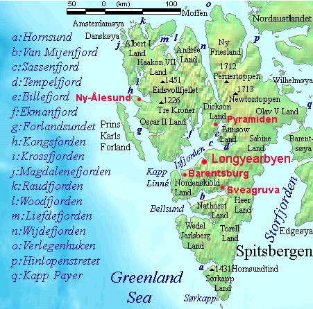
English: Map detailing the marine features of Spitsbergen in the Svalbard archipelago. Settlements and mountains are indicated and labelled. See also Image:Spitsbergen mountains and marine features labelled.png. Locations were labelled mainly based on detailed maps from svalbard-images.com (sample of south Spitsbergen linked), cross-referenced with other map sources where possible. Norwegian Polar Institute figures were used for mountain names and heights, which are given in meters above sea level. |
| Dato | la 25-a de julio 2006 (origina alŝuta dato) |
| Fonto | Nenia maŝinlegebla fonto disponigita. Oni supozas, ke estas propra verko, bazante sur kopirajtaj asertoj. |
| Aŭtoro | Nenia maŝinlegebla fonto disponigita. Oni supozas, ke TheGrappler verkis ĝin, bazante sur kopirajtaj asertoj. |
Permesiloj:
DEMIS World Map Server archive copy at the Wayback Machine generated this map from Public Domain sources. DEMIS does not claim any rights over the resultant image ([1] archive copy at the Wayback Machine). Alterations, including the addition of settlements and captions, were performed on 24 July 2006 by User:TheGrappler, the uploader, who releases all associated rights.
| Public domainPublic domainfalsefalse |
| Mi, la posedanto de la aŭtorrajto por ĉi tiu verko, liberigas ĝin tutmonde kiel publikan havaĵon. En iuj landoj tio povas esti laŭleĝe neebla; en tiu okazo: Mi rajtigas ĉiun ajn uzi ĉi tiun verkon por ajna celo, sen iuj ajn kondiĉoj, krom se tiuj kondiĉoj estas postulataj per leĝo. |
| Public domainPublic domainfalsefalse |
This image is in the public domain because it came from the site https://www.demis.nl/products/web-map-server/examples/ and was released by the copyright holder. Permission is granted to copy, distribute and/or modify this map since it is based on free of copyright images from: www.demis.nl. See also approval email on de.wp and its clarification.
Deutsch | English | македонски | മലയാളം | Nederlands | slovenščina | +/− |
| Public domainPublic domainfalsefalse |
| This work has been released into the public domain by its copyright holder, www.demis.nl. This applies worldwide. En iuj landoj tio povas esti laŭleĝe neebla; en tiu okazo: www.demis.nl donas al iu ajn la rajton uzi ĉi tiun verkon por iu ajn uzo, sen kondiĉoj, krom se tiuj kondiĉoj deviĝas per leĝo. Public domainPublic domainfalsefalse |
Titoloj
Eroj prezentitaj en ĉi tiu dosiero
montras
25 jul. 2006
Dosierhistorio
Alklaku iun daton kaj horon por vidi kiel la dosiero tiam aspektis.
| Dato/Horo | Bildeto | Grandecoj | Uzanto | Komento | |
|---|---|---|---|---|---|
| nun | 09:23, 26 jul. 2006 | | 451 × 446 (161 KB) | TheGrappler | More detail in South |
| 00:58, 25 jul. 2006 |  | 451 × 446 (159 KB) | TheGrappler | Move "Albert I Land" label slightly, to avoid obscuring Magdalenefjorden | |
| 00:46, 25 jul. 2006 |  | 451 × 446 (160 KB) | TheGrappler | == Summary == {{English}} Map detailing the marine features of Spitsbergen in the Svalbard archipelago. Settlements and mountains are indicated and labelled. See also Image:Spitsbergen mountains and marine features labelled.png. Locations were labell |
Dosiera uzado
La jenaj paĝoj ligas al ĉi tiu dosiero:
Suma uzado de la dosiero
La jenaj aliaj vikioj utiligas ĉi tiun dosieron:
- Uzado en af.wikipedia.org
- Uzado en ast.wikipedia.org
- Uzado en az.wikipedia.org
- Uzado en bg.wikipedia.org
- Uzado en ca.wikipedia.org
- Uzado en cv.wikipedia.org
- Uzado en da.wikipedia.org
- Uzado en de.wikipedia.org
- Uzado en el.wikipedia.org
- Uzado en en.wikipedia.org
- Spitsbergen
- Danes Island
- Isfjorden (Svalbard)
- Wijdefjorden
- Van Mijenfjorden
- Olav V Land
- Fairhaven (Svalbard)
- Bellsund
- Magdalenefjorden
- Recherche Fjord
- Forlandsundet
- Engelskbukta
- Amsterdam Island (Spitsbergen)
- Van Muydenbukta
- Van Keulenfjorden
- Krossfjorden
- Billefjorden
- Adventfjorden
- Grønfjorden
- Ekmanfjorden
- Moffen
- Sørkappøya
Vidi plian ĝeneralan uzadon de ĉi tiu dosiero.