Map Graph

Wye, Kent

Human settlement in England

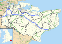
Wye is a village and former civil parish, now in the parish of Wye with Hinxhill, in the Ashford district, in Kent, England, 5 miles (8.0 km) from Ashford and 12 miles (19 km) from Canterbury. It is the main settlement in the parish of Wye with Hinxhill. Hop varieties including Wye Challenger were bred at Wye College and named for the village.

Read article
File:St_Gregory_St_Martin_Wye_1.jpgFile:Kent_UK_location_map.svgFile:123_and_125_Bridge_Street,_Wye,_Kent_-_geograph.org.uk_-_1393600.jpgFile:Church_Street,_Wye_-_geograph.org.uk_-_793552.jpgFile:Sluice_on_Great_Stour_-_geograph.org.uk_-_1154923.jpgFile:Wye_College_-_geograph.org.uk_-_1411252.jpgFile:Stour_Valley_Walk_in_Wye_-_geograph.org.uk_-_1457532.jpgFile:Wye_Crown.jpgFile:The_Green,_Wye_-_geograph.org.uk_-_385541.jpgFile:St_Gregory_and_St_Martin,_Wye,_Kent_-_geograph.org.uk_-_324787.jpgFile:Spring_Grove_Oast,_Brambling,_Harville_Road,_Wye,_Kent_-_geograph.org.uk_-_1076218.jpgFile:The_New_Flying_Horse,_Upper_Bridge_Street,_Wye_-_geograph.org.uk_-_478912.jpgFile:Lady_Joanna_Thornhill_School,_Wye_-_geograph.org.uk_-_3466574.jpgFile:Wye_Bridge-geograph.org.uk-4258990.jpgFile:Wye_watermill_1982.JPGFile:Wye_watermill.jpgFile:1159_-_WYE_WITHERSDANE_HALL_OLD_HOUSE_ACROSS_LAWN_FROM_HOLLANDS_FIELD_AND_CEAS.jpgFile:Wye_Station_from_across_the_level_crossing_-_geograph.org.uk_-_1562542.jpgFile:Kent_Long_Distance_Footpaths.pngFile:North_Downs_Way_and_Stour_Valley_Walk_in_Wye_-_geograph.org.uk_-_1457530.jpg
Top Questions
AI generated

List the top facts about Wye, Kent

Summarize this article

What is the single most intriguing fact about Wye, Kent?

Are there any controversies surrounding Wye, Kent?

More questions