Map Graph
No coordinates found

Geography of Lebanon

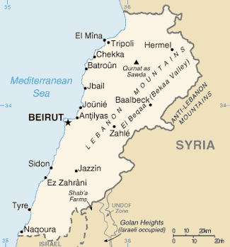
Lebanon is a small country in the Levant region of the Eastern Mediterranean, located at approximately 34˚N, 35˚E. It stretches along the eastern shore of the Mediterranean Sea and its length is almost three times its width. From north to south, the width of its terrain becomes narrower. Lebanon's mountainous terrain, proximity to the sea, and strategic location at a crossroads of the world were decisive factors in shaping its history.

Read article
File:Lebanon_2002_CIA_map.jpgFile:Jayroun,_Lebanon_-_panoramio.jpgFile:White_mule_in_the_Dunnieh_Mountains,_North_Lebanon.jpgFile:Jabal_Moussa_Biosphere_Reserve_03.jpgFile:View_of_the_Kadisha_Valley,_Lebanon.jpgFile:Lebanese_coastline,_Oct_2012.jpgFile:Bteghrine_from_Haret_Ali.JPGFile:Koppen-Geiger_Map_LBN_present.svgFile:Satellite_image_of_Lebanon_in_March_2002.jpgFile:March_2011_Snow_in_Lebanon.jpgFile:Map_of_Lebanon.pngFile:Lebanon_Rivers_Map.jpgFile:Flagship_air_monitoring_station_in_Beirut.jpg
Top Questions
AI generated

List the top facts about Geography of Lebanon

Summarize this article

What is the single most intriguing fact about Geography of Lebanon?

Are there any controversies surrounding Geography of Lebanon?

More questions