Vistula Fens
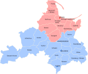
River delta of the VistulaŻuławy Wiślane, in English known as the Vistula Fens, is the alluvial delta area of the river Vistula, in the northern part of Poland. It is a flat and deforested region comprising wetlands and agricultural plains that cover approximately 1,700 squared kilometres, with much of the land being situated below sea level. Poland's lowest point is located at Raczki Elbląskie in the Żuławy region.
Read article
Top Questions
AI generatedMore questions
Nearby Places

Danzig (region)
Former region in Prussia
Brzózki, Pomeranian Voivodeship
Village in Pomeranian Voivodeship, Poland
Lubiszewo Drugie
Village in Pomeranian Voivodeship, Poland
Mirowo, Pomeranian Voivodeship
Village in Pomeranian Voivodeship, Poland
Stawiec, Malbork County
Settlement in Pomeranian Voivodeship, Poland
Lubieszewo Pierwsze
Village in Pomeranian Voivodeship, Poland
Lubieszynek Drugi
Village in Pomeranian Voivodeship, Poland
Stawiec, Nowy Dwór Gdański County
Village in Pomeranian Voivodeship, Poland


